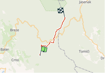
![](/images/other/stat-length.png)
![Tocht Te voet Unknown - Kapelskim planinarskim putom prema moru - Photo](https://media.geolcdn.com/t/1900/400/ext.pjpeg?maxdim=2&url=https%3A%2F%2Fstatic1.geolcdn.com%2Fsiteimages%2Fupload%2Ffiles%2F1545311037marcheuse_200dpi.jpg)
Kapelskim planinarskim putom prema moru
SityTrail - itinéraires balisés pédestres
Tous les sentiers balisés d’Europe GUIDE+
![Lengte](/images/other/stat-length.png)
![Max. hoogte](https://static1.geolcdn.com/siteimages/upload/files/1508320355ic_sort_altitude_max_24dp.png)
![Positief hoogteverschil](https://static1.geolcdn.com/siteimages/upload/files/1508320355ic_sort_den_pos_24dp.png)
![Km-Effort](/images/other/stat-length.png)
![Min. hoogte](https://static1.geolcdn.com/siteimages/upload/files/1508320355ic_sort_altitude_min_24dp.png)
![Negatief hoogteverschil](https://static1.geolcdn.com/siteimages/upload/files/1508320355ic_sort_den_neg_24dp.png)
![Boucle](https://static1.geolcdn.com/siteimages/upload/files/16400158638029165_repeat_loop_refresh_sync_direction_icon.png)
![Te voet](https://static1.geolcdn.com/sitytour/trail-icons/100.png)
4h41
Moeilijkheid : Medium
![Scan deze QR-code om de tocht te openen in de SityTrail-applicatie](https://capi.geolives.com/qq0zvz2zws4bq2lad0pu/sitytour/trails/4346123/qr.png?size=200)
Gratisgps-wandelapplicatie
Over ons
Tocht Te voet van 11,8 km beschikbaar op Onbekend, Primorsko-goranska županija. Deze tocht wordt voorgesteld door SityTrail - itinéraires balisés pédestres.
Beschrijving
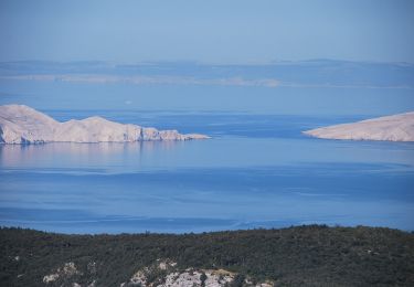
In the area where Velika Kapela approaches the sea, we come across one of the largest forest expanses in Croatia. There are no settlements in the area from Bjelolasica and the sites of Bijele stijene and Samarske stijene to the edge of the regions of Gorski kotar and Primorje, and the entire ...
Website: https://trail.viadinarica.com/tour/hiking/15957187/
Plaatsbepaling
Opmerkingen
Wandeltochten in de omgeving
![Tocht Te voet - Spojni put Kapela - Velebit - Photo](https://media.geolcdn.com/t/375/260/f99b71b0-e87a-46c3-adc6-33e04715f498.jpeg&format=jpg&maxdim=2)
![Te voet Te voet](https://static1.geolcdn.com/sitytour/trail-icons/100.png)
Te voet
![](/images/other/stat-length.png)
![](https://static1.geolcdn.com/siteimages/upload/files/16400158638029165_repeat_loop_refresh_sync_direction_icon.png)