![](/images/other/stat-length.png)
![Tocht Te voet Unknown - Gornje Jelenje - Fužine - Photo](https://media.geolcdn.com/t/1900/400/bc446bdd-3cfe-45c0-94f3-3ba2d4e990b4.jpeg&format=pjpeg&maxdim=2)
Gornje Jelenje - Fužine
SityTrail - itinéraires balisés pédestres
Tous les sentiers balisés d’Europe GUIDE+
![Lengte](/images/other/stat-length.png)
![Max. hoogte](https://static1.geolcdn.com/siteimages/upload/files/1508320355ic_sort_altitude_max_24dp.png)
![Positief hoogteverschil](https://static1.geolcdn.com/siteimages/upload/files/1508320355ic_sort_den_pos_24dp.png)
![Km-Effort](/images/other/stat-length.png)
![Min. hoogte](https://static1.geolcdn.com/siteimages/upload/files/1508320355ic_sort_altitude_min_24dp.png)
![Negatief hoogteverschil](https://static1.geolcdn.com/siteimages/upload/files/1508320355ic_sort_den_neg_24dp.png)
![Boucle](https://static1.geolcdn.com/siteimages/upload/files/16400158638029165_repeat_loop_refresh_sync_direction_icon.png)
![Te voet](https://static1.geolcdn.com/sitytour/trail-icons/100.png)
6h36
Moeilijkheid : Medium
![Scan deze QR-code om de tocht te openen in de SityTrail-applicatie](https://capi.geolives.com/qq0zvz2zws4bq2lad0pu/sitytour/trails/4346121/qr.png?size=200)
Gratisgps-wandelapplicatie
Over ons
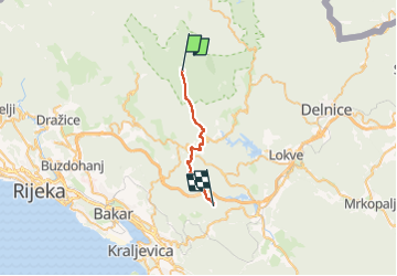
Tocht Te voet van 18,4 km beschikbaar op Onbekend, Primorsko-goranska županija. Deze tocht wordt voorgesteld door SityTrail - itinéraires balisés pédestres.
Beschrijving
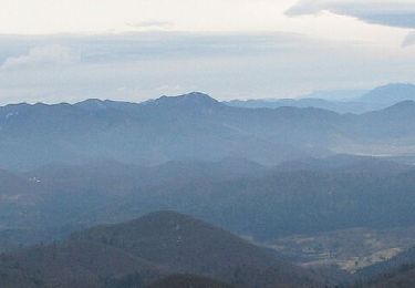
In the area south of the Risnjak National Park, Via Dinarica continues across the area of Tuhobić. This elongated mountain with steep sides follows the littoral edge of the Gorski kotar plateau from Gornje Jelenje towards Fužine for approximately 5 kilometers.
Website: https://trail.viadinarica.com/tour/hiking/15948472/
Plaatsbepaling
Opmerkingen
Wandeltochten in de omgeving
![Tocht Te voet Loška Dolina - Pot prijateljstva Snežnik-Snježnik - Photo](https://media.geolcdn.com/t/375/260/454ce306-fc2c-43e2-8038-3237620763ce.jpeg&format=jpg&maxdim=2)
![Te voet Te voet](https://static1.geolcdn.com/sitytour/trail-icons/100.png)
Te voet
![](/images/other/stat-length.png)
![](https://static1.geolcdn.com/siteimages/upload/files/16400158638029165_repeat_loop_refresh_sync_direction_icon.png)
![Tocht Te voet - Kukuljani - Kastav - Photo](https://media.geolcdn.com/t/375/260/dbbd9bec-d8f7-4124-bf49-f7a77d949ce1.jpeg&format=jpg&maxdim=2)
![Te voet Te voet](https://static1.geolcdn.com/sitytour/trail-icons/100.png)
Te voet
![](/images/other/stat-length.png)
![](https://static1.geolcdn.com/siteimages/upload/files/16400158638029165_repeat_loop_refresh_sync_direction_icon.png)
![Tocht Te voet - Saršoni - Studena - Photo](https://media.geolcdn.com/t/375/260/dbbd9bec-d8f7-4124-bf49-f7a77d949ce1.jpeg&format=jpg&maxdim=2)
![Te voet Te voet](https://static1.geolcdn.com/sitytour/trail-icons/100.png)
Te voet
![](/images/other/stat-length.png)
![](https://static1.geolcdn.com/siteimages/upload/files/16400158638029165_repeat_loop_refresh_sync_direction_icon.png)
![Tocht Te voet - Gornje Jelenje - Vilje - Risnjak - Photo](https://media.geolcdn.com/t/375/260/3a1889fd-b233-412c-8ef2-908620f565dc.jpeg&format=jpg&maxdim=2)
![Te voet Te voet](https://static1.geolcdn.com/sitytour/trail-icons/100.png)
Te voet
![](/images/other/stat-length.png)
![](https://static1.geolcdn.com/siteimages/upload/files/16400158638029165_repeat_loop_refresh_sync_direction_icon.png)
![Tocht Te voet - Ravno Podolje - Medvjeđa vrata - Photo](https://media.geolcdn.com/t/375/260/5f48b32b-f71e-48e9-b8cd-4e462442dbc6.jpeg&format=jpg&maxdim=2)
![Te voet Te voet](https://static1.geolcdn.com/sitytour/trail-icons/100.png)
Te voet
![](/images/other/stat-length.png)
![](https://static1.geolcdn.com/siteimages/upload/files/16400158638029165_repeat_loop_refresh_sync_direction_icon.png)
![Tocht Te voet - Lepenica - Medvjeđa vrata - Risnjak - Photo](https://media.geolcdn.com/t/375/260/3a1889fd-b233-412c-8ef2-908620f565dc.jpeg&format=jpg&maxdim=2)
![Te voet Te voet](https://static1.geolcdn.com/sitytour/trail-icons/100.png)
Te voet
![](/images/other/stat-length.png)
![](https://static1.geolcdn.com/siteimages/upload/files/16400158638029165_repeat_loop_refresh_sync_direction_icon.png)
![Tocht Te voet - Nacionalni park Risnjak - Photo](https://media.geolcdn.com/t/375/260/d7f43ced-7746-4c3c-aa97-9c953327d62b.jpeg&format=jpg&maxdim=2)
![Te voet Te voet](https://static1.geolcdn.com/sitytour/trail-icons/100.png)
Te voet
![](/images/other/stat-length.png)
![](https://static1.geolcdn.com/siteimages/upload/files/16400158638029165_repeat_loop_refresh_sync_direction_icon.png)
![Tocht Te voet - Tršće - Sveta gora - Izvor Kupe - Crni Lug - Photo](https://media.geolcdn.com/t/375/260/60013492-baa6-4369-bcba-b910bef47edc.jpeg&format=jpg&maxdim=2)
![Te voet Te voet](https://static1.geolcdn.com/sitytour/trail-icons/100.png)
Te voet
![](/images/other/stat-length.png)
![](https://static1.geolcdn.com/siteimages/upload/files/16400158638029165_repeat_loop_refresh_sync_direction_icon.png)
![Tocht Te voet - Prezid - Čabar - Tršće - Photo](https://media.geolcdn.com/t/375/260/63396e8a-0219-4975-8a92-2dc12ba77793.jpeg&format=jpg&maxdim=2)
![Te voet Te voet](https://static1.geolcdn.com/sitytour/trail-icons/100.png)
Te voet
![](/images/other/stat-length.png)
![](https://static1.geolcdn.com/siteimages/upload/files/16400158638029165_repeat_loop_refresh_sync_direction_icon.png)