Tocht Te voet Unknown - Tršće - Sveta gora - Izvor Kupe - Crni Lug - Photo

Tršće - Sveta gora - Izvor Kupe - Crni Lug

Tous les sentiers balisés d’Europe GUIDE+

© OpenStreetMap contributors
Lengte
Lengte
15,3 km
Max. hoogte
Max. hoogte
948 m
Positief hoogteverschil
525 m
Km-Effort
Km-Effort  
24 km
Min. hoogte
Min. hoogte
311 m
Negatief hoogteverschil
1012 m
Boucle
Boucle
Neen
Markering
Markering
Datum van aanmaak :
2025-02-07 16:02:45.125
Laatste wijziging :
2025-02-07 16:02:45.125

(0 Bericht)

Te voet
Te voet
5h25
Moeilijkheid : Medium

Scan deze QR-code om de tocht te openen in de SityTrail-applicatie

Gratisgps-wandelapplicatie

Logo SityTrail SityTrail

IGN / Geografische instituten

SityTrail uit de App Store downloaden SityTrail uit Google Play downloaden

Logo SityTrail SityTrail World

De wereld gaat voor u open

SityTrail uit de App Store downloaden SityTrail uit Google Play downloaden SityTrail op Huawei AppGallery downloaden

Over ons

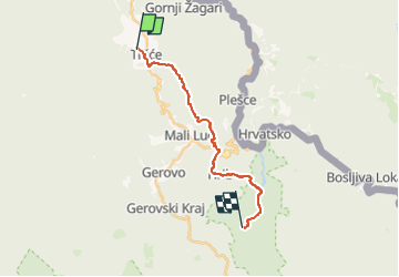
Tocht Te voet van 15,3 km beschikbaar op Onbekend, Primorsko-goranska županija. Deze tocht wordt voorgesteld door SityTrail - itinéraires balisés pédestres.

Beschrijving

In the area from Tršće to Risnjak National Park, Via Dinarica follows the route of Gorski Kotar Hiking Trail. The trail is well kept and maintained. From Tršće, we first need to climb to the village of Kraljev Vrh by road. From there, we then continue by following the hiking trail markings ...

Website: https://trail.viadinarica.com/tour/hiking/15948208/

Hoogteprofiel

Foto's

Plaatsbepaling

Land:
Croatia
Regio :
Onbekend
Departement/Provincie :
Primorsko-goranska županija
Gemeente :
Unknown
Locatie:
Unknown
Vertrek:(UTM)
470662 ; 5046214 (33T) N.

Wandeltochten in de omgeving

Tocht Te voet  - Prezid - Čabar - Tršće - Photo
Te voet
GUIDE+

Te voet

Gemakkelijk
, Onbekend, Primorsko-goranska županija, Croatia
4,9 km | 7,1 km-effort
1h 36min
Neen


Sluiten
Mijn abonnementen