![](/images/other/stat-length.png)
![Tocht Te voet Černolice - NS Putování Černolickem - Photo](https://media.geolcdn.com/t/1900/400/3d6ca1f7-5098-486f-a0ff-96334a205635.jpeg&format=pjpeg&maxdim=2)
NS Putování Černolickem
SityTrail - itinéraires balisés pédestres
Tous les sentiers balisés d’Europe GUIDE+
![Lengte](/images/other/stat-length.png)
Lengte
4,2 km
![Max. hoogte](https://static1.geolcdn.com/siteimages/upload/files/1508320355ic_sort_altitude_max_24dp.png)
Max. hoogte
430 m
![Positief hoogteverschil](https://static1.geolcdn.com/siteimages/upload/files/1508320355ic_sort_den_pos_24dp.png)
Positief hoogteverschil
134 m
![Km-Effort](/images/other/stat-length.png)
Km-Effort
6 km
![Min. hoogte](https://static1.geolcdn.com/siteimages/upload/files/1508320355ic_sort_altitude_min_24dp.png)
Min. hoogte
299 m
![Negatief hoogteverschil](https://static1.geolcdn.com/siteimages/upload/files/1508320355ic_sort_den_neg_24dp.png)
Negatief hoogteverschil
123 m
![Boucle](https://static1.geolcdn.com/siteimages/upload/files/16400158638029165_repeat_loop_refresh_sync_direction_icon.png)
Boucle
Ja
Markering
Datum van aanmaak :
2025-02-07 15:23:57.836
Laatste wijziging :
2025-02-07 15:23:57.836
![Te voet](https://static1.geolcdn.com/sitytour/trail-icons/100.png)
1h21
Moeilijkheid : Gemakkelijk
![Scan deze QR-code om de tocht te openen in de SityTrail-applicatie](https://capi.geolives.com/qq0zvz2zws4bq2lad0pu/sitytour/trails/4346002/qr.png?size=200)
Gratisgps-wandelapplicatie
Over ons
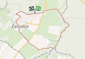
Tocht Te voet van 4,2 km beschikbaar op Centraal-Bohemen, Onbekend, Černolice. Deze tocht wordt voorgesteld door SityTrail - itinéraires balisés pédestres.
Beschrijving
Tocht aangemaakt door cz:KČT.
Plaatsbepaling
Land:
Czech Republic
Regio :
Centraal-Bohemen
Departement/Provincie :
Onbekend
Gemeente :
Černolice
Locatie:
Unknown
Vertrek:(Dec)
Vertrek:(UTM)
450090 ; 5529164 (33U) N.
Opmerkingen
Wandeltochten in de omgeving
![Tocht Te voet Mníšek pod Brdy - NS Mníšek pod Brdy - Photo](https://media.geolcdn.com/t/375/260/2a565180-058b-44a6-b5b6-fdf61dda7657.jpeg&format=jpg&maxdim=2)
![Te voet Te voet](https://static1.geolcdn.com/sitytour/trail-icons/100.png)
NS Mníšek pod Brdy
Te voet
Gemakkelijk
Mníšek pod Brdy,
Centraal-Bohemen,
Onbekend,
Czech Republic
![](/images/other/stat-length.png)
3,6 km | 4,7 km-effort
1h 4min
![](https://static1.geolcdn.com/siteimages/upload/files/16400158638029165_repeat_loop_refresh_sync_direction_icon.png)
Neen
![Tocht Te voet Vonoklasy - [Ž] naučná stezka Okolím Vonoklas - Photo](https://media.geolcdn.com/t/375/260/a46e5b70-316a-4a51-9da1-6a1325bde378.jpeg&format=jpg&maxdim=2)
![Te voet Te voet](https://static1.geolcdn.com/sitytour/trail-icons/100.png)
[Ž] naučná stezka Okolím Vonoklas
Te voet
Gemakkelijk
Vonoklasy,
Centraal-Bohemen,
Onbekend,
Czech Republic
![](/images/other/stat-length.png)
8,1 km | 11,1 km-effort
2h 30min
![](https://static1.geolcdn.com/siteimages/upload/files/16400158638029165_repeat_loop_refresh_sync_direction_icon.png)
Ja
![Tocht Te voet Jíloviště - [Z] Jíloviště - Všenory - Photo](https://media.geolcdn.com/t/375/260/06630537-e029-451b-a301-b274a78a918c.jpeg&format=jpg&maxdim=2)
![Te voet Te voet](https://static1.geolcdn.com/sitytour/trail-icons/100.png)
[Z] Jíloviště - Všenory
Te voet
Gemakkelijk
Jíloviště,
Centraal-Bohemen,
Onbekend,
Czech Republic
![](/images/other/stat-length.png)
4,1 km | 5,5 km-effort
1h 14min
![](https://static1.geolcdn.com/siteimages/upload/files/16400158638029165_repeat_loop_refresh_sync_direction_icon.png)
Neen
![Tocht Te voet Trnová - NS Jíloviště - Cukrák - Photo](https://media.geolcdn.com/t/375/260/b4c50bf3-118e-42f6-aafb-28d2d3bc79a4.jpeg&format=jpg&maxdim=2)
![Te voet Te voet](https://static1.geolcdn.com/sitytour/trail-icons/100.png)
NS Jíloviště - Cukrák
Te voet
Gemakkelijk
Trnová,
Centraal-Bohemen,
Onbekend,
Czech Republic
![](/images/other/stat-length.png)
4,4 km | 6,6 km-effort
1h 30min
![](https://static1.geolcdn.com/siteimages/upload/files/16400158638029165_repeat_loop_refresh_sync_direction_icon.png)
Neen
![Tocht Te voet Řevnice - [Z] Řevnice - Kytín - Photo](https://media.geolcdn.com/t/375/260/c64784dc-9468-4f93-9e9f-fe3f39507829.jpeg&format=jpg&maxdim=2)
![Te voet Te voet](https://static1.geolcdn.com/sitytour/trail-icons/100.png)
[Z] Řevnice - Kytín
Te voet
Gemakkelijk
Řevnice,
Centraal-Bohemen,
Onbekend,
Czech Republic
![](/images/other/stat-length.png)
10,6 km | 15,4 km-effort
3h 30min
![](https://static1.geolcdn.com/siteimages/upload/files/16400158638029165_repeat_loop_refresh_sync_direction_icon.png)
Neen
![Tocht Te voet Jíloviště - [Ž] Jíloviště - Černošice - Photo](https://media.geolcdn.com/t/375/260/658263c1-3fcf-44eb-9c17-2cb3a74b2689.jpeg&format=jpg&maxdim=2)
![Te voet Te voet](https://static1.geolcdn.com/sitytour/trail-icons/100.png)
[Ž] Jíloviště - Černošice
Te voet
Gemakkelijk
Jíloviště,
Centraal-Bohemen,
Onbekend,
Czech Republic
![](/images/other/stat-length.png)
6,3 km | 7,9 km-effort
1h 48min
![](https://static1.geolcdn.com/siteimages/upload/files/16400158638029165_repeat_loop_refresh_sync_direction_icon.png)
Neen
![Tocht Te voet Dobřichovice - [Z] Dobřichovice-Třebotov-Černošice - Photo](https://media.geolcdn.com/t/375/260/658263c1-3fcf-44eb-9c17-2cb3a74b2689.jpeg&format=jpg&maxdim=2)
![Te voet Te voet](https://static1.geolcdn.com/sitytour/trail-icons/100.png)
[Z] Dobřichovice-Třebotov-Černošice
Te voet
Gemakkelijk
Dobřichovice,
Centraal-Bohemen,
Onbekend,
Czech Republic
![](/images/other/stat-length.png)
12,3 km | 16,9 km-effort
3h 50min
![](https://static1.geolcdn.com/siteimages/upload/files/16400158638029165_repeat_loop_refresh_sync_direction_icon.png)
Neen
![Tocht Te voet Čisovice - [Z] Bojov-Davle - Photo](https://media.geolcdn.com/t/375/260/0a1d902c-ad6e-40f3-ac52-7211c51fb088.jpeg&format=jpg&maxdim=2)
![Te voet Te voet](https://static1.geolcdn.com/sitytour/trail-icons/100.png)
[Z] Bojov-Davle
Te voet
Gemakkelijk
Čisovice,
Centraal-Bohemen,
Onbekend,
Czech Republic
![](/images/other/stat-length.png)
5 km | 6,4 km-effort
1h 27min
![](https://static1.geolcdn.com/siteimages/upload/files/16400158638029165_repeat_loop_refresh_sync_direction_icon.png)
Neen