


3,7 km | 5,1 km-effort
![Tocht Te voet Chřibská - [M] Chřibská - Rybniště (žst) - Photo](https://media.geolcdn.com/t/1900/400/ec85bc98-2fdb-4814-b82a-0c53d51cc939.jpeg&format=pjpeg&maxdim=2)

Tous les sentiers balisés d’Europe GUIDE+


Gratisgps-wandelapplicatie
 SityTrail
IGN / Geografische instituten
SityTrail World
De wereld gaat voor u open
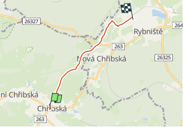
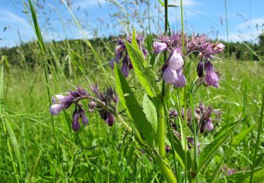
Tocht Te voet van 3,4 km beschikbaar op Noordwest, Ústecký kraj, Chřibská. Deze tocht wordt voorgesteld door SityTrail - itinéraires balisés pédestres.
Tocht aangemaakt door cz:KČT.
![Tocht Te voet Chřibská - [M] Chřibská - Rybniště (žst) - Photo 1](https://media.geolcdn.com/t/2048/auto/73bc80f4-f5c7-4f6f-a62f-6801f0565974.jpeg&format=jpg&maxdim=0 "Tocht Te voet Chřibská - [M] Chřibská - Rybniště (žst) - Photo 1")
![Tocht Te voet Chřibská - [M] Chřibská - Rybniště (žst) - Photo 2](https://media.geolcdn.com/t/2048/auto/c460f5dc-b470-4b8d-bc72-0c42b94893b9.jpeg&format=jpg&maxdim=0 "Tocht Te voet Chřibská - [M] Chřibská - Rybniště (žst) - Photo 2")
![Tocht Te voet Chřibská - [M] Chřibská - Rybniště (žst) - Photo 3](https://media.geolcdn.com/t/2048/auto/dcfb4557-b603-4466-8d1c-c1af3894ed90.jpeg&format=jpg&maxdim=0 "Tocht Te voet Chřibská - [M] Chřibská - Rybniště (žst) - Photo 3")
![Tocht Te voet Chřibská - [M] Chřibská - Rybniště (žst) - Photo 4](https://media.geolcdn.com/t/2048/auto/2625006a-3150-45f0-965b-ddcdd6bf01a9.jpeg&format=jpg&maxdim=0 "Tocht Te voet Chřibská - [M] Chřibská - Rybniště (žst) - Photo 4")
![Tocht Te voet Chřibská - [M] Chřibská - Rybniště (žst) - Photo 5](https://media.geolcdn.com/t/2048/auto/53bdc28b-d52a-4786-8fb6-1096fdf91bbd.jpeg&format=jpg&maxdim=0 "Tocht Te voet Chřibská - [M] Chřibská - Rybniště (žst) - Photo 5")
![Tocht Te voet Chřibská - [M] Chřibská - Rybniště (žst) - Photo 6](https://media.geolcdn.com/t/2048/auto/c09b1245-db07-4014-92de-32a53439deb1.jpeg&format=jpg&maxdim=0 "Tocht Te voet Chřibská - [M] Chřibská - Rybniště (žst) - Photo 6")
![Tocht Te voet Chřibská - [M] Chřibská - Rybniště (žst) - Photo 7](https://media.geolcdn.com/t/2048/auto/7eec0d9a-853e-425e-8bb9-0d8be0cc09ea.jpeg&format=jpg&maxdim=0 "Tocht Te voet Chřibská - [M] Chřibská - Rybniště (žst) - Photo 7")
![Tocht Te voet Chřibská - [M] Chřibská - Rybniště (žst) - Photo 8](https://media.geolcdn.com/t/2048/auto/3cdef84f-42db-4a34-a4f0-5c52ac1b0dbf.jpeg&format=jpg&maxdim=0 "Tocht Te voet Chřibská - [M] Chřibská - Rybniště (žst) - Photo 8")
![Tocht Te voet Chřibská - [M] Chřibská - Rybniště (žst) - Photo 9](https://media.geolcdn.com/t/2048/auto/033976bc-fe90-4a00-a983-88d3a58880a3.jpeg&format=jpg&maxdim=0 "Tocht Te voet Chřibská - [M] Chřibská - Rybniště (žst) - Photo 9")
![Tocht Te voet Chřibská - [M] Chřibská - Rybniště (žst) - Photo 10](https://media.geolcdn.com/t/2048/auto/ec85bc98-2fdb-4814-b82a-0c53d51cc939.jpeg&format=jpg&maxdim=0 "Tocht Te voet Chřibská - [M] Chřibská - Rybniště (žst) - Photo 10")
Te voet
Te voet
![Tocht Te voet Krásná Lípa - [M] Brtnický okruh - Photo](https://media.geolcdn.com/t/375/260/2c25ed32-bc80-4d66-bfb8-31499feb073b.jpeg&format=jpg&maxdim=2)
Te voet
Te voet
Te voet
![Tocht Te voet Jetřichovice - [Z] Dolský mlýn - Pod Borovinou - Photo](https://media.geolcdn.com/t/375/260/cc7734bc-a1cb-44c1-a579-3999a7e367e8.jpeg&format=jpg&maxdim=2)
Te voet
![Tocht Te voet Huntířov - [Z] Oleška - Srbská Kamenice - Photo](https://media.geolcdn.com/t/375/260/b671590f-17dc-4f55-a338-c89d99bb2f15.jpeg&format=jpg&maxdim=2)
Te voet
Te voet
Te voet