![](/images/other/stat-length.png)
![Tocht Te voet Běleč - NS Kolem hradu Šelmberk - Photo](https://media.geolcdn.com/t/1900/400/433e6df1-235e-4119-853d-9b1923407fbb.jpeg&format=pjpeg&maxdim=2)
NS Kolem hradu Šelmberk
SityTrail - itinéraires balisés pédestres
Tous les sentiers balisés d’Europe GUIDE+
![Lengte](/images/other/stat-length.png)
Lengte
3,1 km
![Max. hoogte](https://static1.geolcdn.com/siteimages/upload/files/1508320355ic_sort_altitude_max_24dp.png)
Max. hoogte
497 m
![Positief hoogteverschil](https://static1.geolcdn.com/siteimages/upload/files/1508320355ic_sort_den_pos_24dp.png)
Positief hoogteverschil
88 m
![Km-Effort](/images/other/stat-length.png)
Km-Effort
4,3 km
![Min. hoogte](https://static1.geolcdn.com/siteimages/upload/files/1508320355ic_sort_altitude_min_24dp.png)
Min. hoogte
422 m
![Negatief hoogteverschil](https://static1.geolcdn.com/siteimages/upload/files/1508320355ic_sort_den_neg_24dp.png)
Negatief hoogteverschil
86 m
![Boucle](https://static1.geolcdn.com/siteimages/upload/files/16400158638029165_repeat_loop_refresh_sync_direction_icon.png)
Boucle
Ja
Markering
Datum van aanmaak :
2025-02-07 13:31:44.877
Laatste wijziging :
2025-02-07 13:31:44.877
![Te voet](https://static1.geolcdn.com/sitytour/trail-icons/100.png)
58m
Moeilijkheid : Gemakkelijk
![Scan deze QR-code om de tocht te openen in de SityTrail-applicatie](https://capi.geolives.com/qq0zvz2zws4bq2lad0pu/sitytour/trails/4345698/qr.png?size=200)
Gratisgps-wandelapplicatie
Over ons
Tocht Te voet van 3,1 km beschikbaar op Zuidwest, Zuid-Bohemen, Běleč. Deze tocht wordt voorgesteld door SityTrail - itinéraires balisés pédestres.
Beschrijving
Tocht aangemaakt door cz:KČT.
Plaatsbepaling
Land:
Czech Republic
Regio :
Zuidwest
Departement/Provincie :
Zuid-Bohemen
Gemeente :
Běleč
Locatie:
Unknown
Vertrek:(Dec)
Vertrek:(UTM)
487452 ; 5488347 (33U) N.
Opmerkingen
Wandeltochten in de omgeving
![Tocht Te voet Olbramovice - [Ž] Olbramovice - Maršovice - Photo](https://media.geolcdn.com/t/375/260/fcfa49ac-91dc-4853-bda2-121affd2edcc.jpeg&format=jpg&maxdim=2)
![Te voet Te voet](https://static1.geolcdn.com/sitytour/trail-icons/100.png)
[Ž] Olbramovice - Maršovice
Te voet
Gemakkelijk
Olbramovice,
Centraal-Bohemen,
Onbekend,
Czech Republic
![](/images/other/stat-length.png)
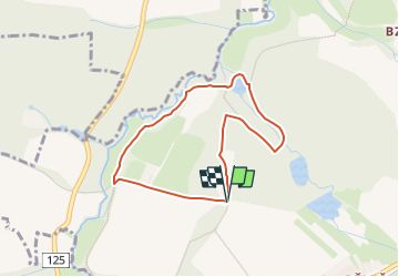
13,3 km | 15,6 km-effort
3h 32min
![](https://static1.geolcdn.com/siteimages/upload/files/16400158638029165_repeat_loop_refresh_sync_direction_icon.png)
Neen
![Tocht Te voet Olbramovice - [Ž] Tomice - Postupice - Photo](https://media.geolcdn.com/t/375/260/af13a085-1fa8-46a2-b383-7b15f6a78e93.jpeg&format=jpg&maxdim=2)
![Te voet Te voet](https://static1.geolcdn.com/sitytour/trail-icons/100.png)
[Ž] Tomice - Postupice
Te voet
Gemakkelijk
Olbramovice,
Centraal-Bohemen,
Onbekend,
Czech Republic
![](/images/other/stat-length.png)
11,9 km | 15,8 km-effort
3h 35min
![](https://static1.geolcdn.com/siteimages/upload/files/16400158638029165_repeat_loop_refresh_sync_direction_icon.png)
Neen
![Tocht Te voet Jankov - [M] Jankov - Šlapánov - Photo](https://media.geolcdn.com/t/375/260/f1e61c24-bcd9-4c3d-8b56-83bf262c1d45.jpeg&format=jpg&maxdim=2)
![Te voet Te voet](https://static1.geolcdn.com/sitytour/trail-icons/100.png)
[M] Jankov - Šlapánov
Te voet
Gemakkelijk
Jankov,
Centraal-Bohemen,
Onbekend,
Czech Republic
![](/images/other/stat-length.png)
8 km | 10,3 km-effort
2h 19min
![](https://static1.geolcdn.com/siteimages/upload/files/16400158638029165_repeat_loop_refresh_sync_direction_icon.png)
Neen
![Tocht Te voet Louňovice pod Blaníkem - Malý Blaník – Podlesí - Photo](https://media.geolcdn.com/t/375/260/934bf68e-9258-4b35-a468-75765872bf6b.jpeg&format=jpg&maxdim=2)
![Te voet Te voet](https://static1.geolcdn.com/sitytour/trail-icons/100.png)
Malý Blaník – Podlesí
Te voet
Gemakkelijk
Louňovice pod Blaníkem,
Centraal-Bohemen,
Onbekend,
Czech Republic
![](/images/other/stat-length.png)
4,4 km | 6,7 km-effort
1h 31min
![](https://static1.geolcdn.com/siteimages/upload/files/16400158638029165_repeat_loop_refresh_sync_direction_icon.png)
Neen
![Tocht Te voet Střezimíř - [Ž] Střezimíř-Vestec - Photo](https://media.geolcdn.com/t/375/260/741f7653-64d2-46f3-ad9c-bd79bc7c5f08.jpeg&format=jpg&maxdim=2)
![Te voet Te voet](https://static1.geolcdn.com/sitytour/trail-icons/100.png)
[Ž] Střezimíř-Vestec
Te voet
Gemakkelijk
Střezimíř,
Centraal-Bohemen,
Onbekend,
Czech Republic
![](/images/other/stat-length.png)
3,2 km | 4 km-effort
54min
![](https://static1.geolcdn.com/siteimages/upload/files/16400158638029165_repeat_loop_refresh_sync_direction_icon.png)
Neen
![Tocht Te voet Sezimovo Ústí - [M] Sezimovo Ústí - Planá nad Lužnicí - Photo](https://media.geolcdn.com/t/375/260/5b6d0c4e-5d11-4cd9-9c2c-b6cbb176e445.jpeg&format=jpg&maxdim=2)
![Te voet Te voet](https://static1.geolcdn.com/sitytour/trail-icons/100.png)
[M] Sezimovo Ústí - Planá nad Lužnicí
Te voet
Gemakkelijk
Sezimovo Ústí,
Zuidwest,
Zuid-Bohemen,
Czech Republic
![](/images/other/stat-length.png)
5,2 km | 6 km-effort
1h 21min
![](https://static1.geolcdn.com/siteimages/upload/files/16400158638029165_repeat_loop_refresh_sync_direction_icon.png)
Neen
![Tocht Te voet Chotoviny - [Ž] U Obrázku - Sudoměřice - Chotoviny - Photo](https://media.geolcdn.com/t/375/260/f7339841-f981-41ea-8ead-dcdc4c14e1ae.jpeg&format=jpg&maxdim=2)
![Te voet Te voet](https://static1.geolcdn.com/sitytour/trail-icons/100.png)
[Ž] U Obrázku - Sudoměřice - Chotoviny
Te voet
Gemakkelijk
Chotoviny,
Zuidwest,
Zuid-Bohemen,
Czech Republic
![](/images/other/stat-length.png)
6,2 km | 8,1 km-effort
1h 50min
![](https://static1.geolcdn.com/siteimages/upload/files/16400158638029165_repeat_loop_refresh_sync_direction_icon.png)
Neen
![Tocht Te voet Votice - [Ž] Votice - Bedřichovice - Photo](https://media.geolcdn.com/t/375/260/2ce5b858-b6e4-44fe-855c-29dd5eeaffeb.jpeg&format=jpg&maxdim=2)
![Te voet Te voet](https://static1.geolcdn.com/sitytour/trail-icons/100.png)
[Ž] Votice - Bedřichovice
Te voet
Medium
Votice,
Centraal-Bohemen,
Onbekend,
Czech Republic
![](/images/other/stat-length.png)
15 km | 20 km-effort
4h 33min
![](https://static1.geolcdn.com/siteimages/upload/files/16400158638029165_repeat_loop_refresh_sync_direction_icon.png)
Neen
![Tocht Te voet Zvěstov - [Ž] Louňovice pod Blaníkem - Roudný - Photo](https://media.geolcdn.com/t/375/260/1571019f-e1b3-4564-be94-1af0efa6ada2.jpeg&format=jpg&maxdim=2)
![Te voet Te voet](https://static1.geolcdn.com/sitytour/trail-icons/100.png)
[Ž] Louňovice pod Blaníkem - Roudný
Te voet
Gemakkelijk
Zvěstov,
Centraal-Bohemen,
Onbekend,
Czech Republic
![](/images/other/stat-length.png)
4,3 km | 5,4 km-effort
1h 13min
![](https://static1.geolcdn.com/siteimages/upload/files/16400158638029165_repeat_loop_refresh_sync_direction_icon.png)
Neen