


4 km | 4,2 km-effort
![Tocht Te voet Malšice - [Z] Dražičky - Matoušovský mlýn - Photo](https://media.geolcdn.com/t/1900/400/898efff3-8919-46f9-9e35-ec28c8db5fd6.jpeg&format=pjpeg&maxdim=2)

Tous les sentiers balisés d’Europe GUIDE+


Gratisgps-wandelapplicatie
 SityTrail
IGN / Geografische instituten
SityTrail World
De wereld gaat voor u open
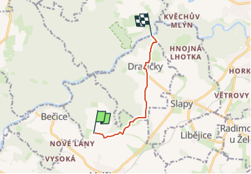
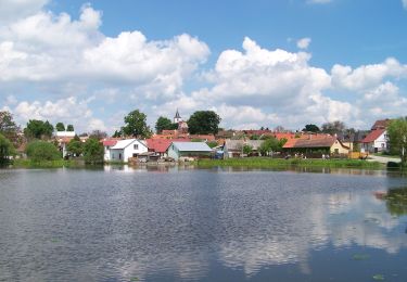
Tocht Te voet van 5,7 km beschikbaar op Zuidwest, Zuid-Bohemen, Malšice. Deze tocht wordt voorgesteld door SityTrail - itinéraires balisés pédestres.
Tocht aangemaakt door cz:KČT.
![Tocht Te voet Malšice - [Z] Dražičky - Matoušovský mlýn - Photo 1](https://media.geolcdn.com/t/2048/auto/e11b4dee-cea9-47e0-9d1a-8f3e7ff3d03a.jpeg&format=jpg&maxdim=0 "Tocht Te voet Malšice - [Z] Dražičky - Matoušovský mlýn - Photo 1")
![Tocht Te voet Malšice - [Z] Dražičky - Matoušovský mlýn - Photo 2](https://media.geolcdn.com/t/2048/auto/34efd93d-5a27-4a27-a733-a109ab577e7c.jpeg&format=jpg&maxdim=0 "Tocht Te voet Malšice - [Z] Dražičky - Matoušovský mlýn - Photo 2")
![Tocht Te voet Malšice - [Z] Dražičky - Matoušovský mlýn - Photo 3](https://media.geolcdn.com/t/2048/auto/ec5ac50d-b119-49c6-bd5f-98f0486369b0.jpeg&format=jpg&maxdim=0 "Tocht Te voet Malšice - [Z] Dražičky - Matoušovský mlýn - Photo 3")
![Tocht Te voet Malšice - [Z] Dražičky - Matoušovský mlýn - Photo 4](https://media.geolcdn.com/t/2048/auto/cc0b4016-ea06-4ca1-8a3f-05f81448e790.jpeg&format=jpg&maxdim=0 "Tocht Te voet Malšice - [Z] Dražičky - Matoušovský mlýn - Photo 4")
![Tocht Te voet Malšice - [Z] Dražičky - Matoušovský mlýn - Photo 5](https://media.geolcdn.com/t/2048/auto/3c673154-a1bc-4998-bce2-93a1518bcda3.jpeg&format=jpg&maxdim=0 "Tocht Te voet Malšice - [Z] Dražičky - Matoušovský mlýn - Photo 5")
![Tocht Te voet Malšice - [Z] Dražičky - Matoušovský mlýn - Photo 6](https://media.geolcdn.com/t/2048/auto/cfc7251e-cb0a-45ec-920f-9645ff6bc5bb.jpeg&format=jpg&maxdim=0 "Tocht Te voet Malšice - [Z] Dražičky - Matoušovský mlýn - Photo 6")
![Tocht Te voet Malšice - [Z] Dražičky - Matoušovský mlýn - Photo 7](https://media.geolcdn.com/t/2048/auto/c89217c1-3aad-4885-9364-1f355e187690.jpeg&format=jpg&maxdim=0 "Tocht Te voet Malšice - [Z] Dražičky - Matoušovský mlýn - Photo 7")
![Tocht Te voet Malšice - [Z] Dražičky - Matoušovský mlýn - Photo 8](https://media.geolcdn.com/t/2048/auto/87f2656f-bb45-4081-9096-0a5fdc996dc7.jpeg&format=jpg&maxdim=0 "Tocht Te voet Malšice - [Z] Dražičky - Matoušovský mlýn - Photo 8")
![Tocht Te voet Malšice - [Z] Dražičky - Matoušovský mlýn - Photo 9](https://media.geolcdn.com/t/2048/auto/23f8014e-427c-4c87-8a41-4c8ac2c96d84.jpeg&format=jpg&maxdim=0 "Tocht Te voet Malšice - [Z] Dražičky - Matoušovský mlýn - Photo 9")
![Tocht Te voet Malšice - [Z] Dražičky - Matoušovský mlýn - Photo 10](https://media.geolcdn.com/t/2048/auto/898efff3-8919-46f9-9e35-ec28c8db5fd6.jpeg&format=jpg&maxdim=0 "Tocht Te voet Malšice - [Z] Dražičky - Matoušovský mlýn - Photo 10")
Te voet
![Tocht Te voet Týn nad Vltavou - [Ž] Nad Překvapením - Semenec (rozhl.) - Photo](https://media.geolcdn.com/t/375/260/5b43c739-7905-4a0c-8a8b-63468991b1a9.jpeg&format=jpg&maxdim=2)
Te voet
Te voet
![Tocht Te voet Milevsko - [Č] Milevsko - Jetětice - Photo](https://media.geolcdn.com/t/375/260/19b73443-10f3-4ee2-b906-2593e9794aea.jpeg&format=jpg&maxdim=2)
Te voet
![Tocht Te voet Milevsko - [Ž] Budák rybník - Karlov - Photo](https://media.geolcdn.com/t/375/260/6a7dbc34-5b93-44a1-bcc9-52d789012a05.jpeg&format=jpg&maxdim=2)
Te voet
Te voet
Te voet
Te voet
Te voet