![](/images/other/stat-length.png)
![Tocht Te voet Hudlice - NS Krušná Hora - Photo](https://media.geolcdn.com/t/1900/400/a711eacb-ba7a-4ee3-9692-5b1671ca98fa.jpeg&format=pjpeg&maxdim=2)
NS Krušná Hora
SityTrail - itinéraires balisés pédestres
Tous les sentiers balisés d’Europe GUIDE+
![Lengte](/images/other/stat-length.png)
Lengte
9,6 km
![Max. hoogte](https://static1.geolcdn.com/siteimages/upload/files/1508320355ic_sort_altitude_max_24dp.png)
Max. hoogte
608 m
![Positief hoogteverschil](https://static1.geolcdn.com/siteimages/upload/files/1508320355ic_sort_den_pos_24dp.png)
Positief hoogteverschil
285 m
![Km-Effort](/images/other/stat-length.png)
Km-Effort
13,1 km
![Min. hoogte](https://static1.geolcdn.com/siteimages/upload/files/1508320355ic_sort_altitude_min_24dp.png)
Min. hoogte
422 m
![Negatief hoogteverschil](https://static1.geolcdn.com/siteimages/upload/files/1508320355ic_sort_den_neg_24dp.png)
Negatief hoogteverschil
191 m
![Boucle](https://static1.geolcdn.com/siteimages/upload/files/16400158638029165_repeat_loop_refresh_sync_direction_icon.png)
Boucle
Neen
Markering
Datum van aanmaak :
2025-02-07 12:29:31.662
Laatste wijziging :
2025-02-07 12:29:31.662
![Te voet](https://static1.geolcdn.com/sitytour/trail-icons/100.png)
2h58
Moeilijkheid : Gemakkelijk
![Scan deze QR-code om de tocht te openen in de SityTrail-applicatie](https://capi.geolives.com/qq0zvz2zws4bq2lad0pu/sitytour/trails/4345577/qr.png?size=200)
Gratisgps-wandelapplicatie
Over ons
Tocht Te voet van 9,6 km beschikbaar op Centraal-Bohemen, Onbekend, Hudlice. Deze tocht wordt voorgesteld door SityTrail - itinéraires balisés pédestres.
Beschrijving
Tocht aangemaakt door cz:KČT.
Website: http://www.hudlice-maminka.cz/?hudlice-maminkacz,18
Plaatsbepaling
Land:
Czech Republic
Regio :
Centraal-Bohemen
Departement/Provincie :
Onbekend
Gemeente :
Hudlice
Locatie:
Unknown
Vertrek:(Dec)
Vertrek:(UTM)
422748 ; 5534220 (33U) N.
Opmerkingen
Wandeltochten in de omgeving
![Tocht Te voet Zdice - [Z] NS Zdice, Lesopark Knihov - Photo](https://media.geolcdn.com/t/375/260/2a65a3f0-7c0c-4a65-a1bd-e76ea288cb07.jpeg&format=jpg&maxdim=2)
![Te voet Te voet](https://static1.geolcdn.com/sitytour/trail-icons/100.png)
[Z] NS Zdice, Lesopark Knihov
Te voet
Gemakkelijk
Zdice,
Centraal-Bohemen,
Onbekend,
Czech Republic
![](/images/other/stat-length.png)
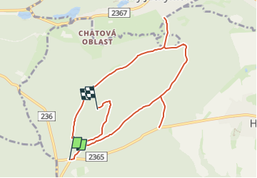
4 km | 5,6 km-effort
1h 16min
![](https://static1.geolcdn.com/siteimages/upload/files/16400158638029165_repeat_loop_refresh_sync_direction_icon.png)
Ja
![Tocht Te voet Zdice - [Ž] U Boudy - Zdice - Photo](https://media.geolcdn.com/t/375/260/a5688116-b31d-4f1b-a93f-e53a022a1471.jpeg&format=jpg&maxdim=2)
![Te voet Te voet](https://static1.geolcdn.com/sitytour/trail-icons/100.png)
[Ž] U Boudy - Zdice
Te voet
Gemakkelijk
Zdice,
Centraal-Bohemen,
Onbekend,
Czech Republic
![](/images/other/stat-length.png)
4 km | 6,6 km-effort
1h 30min
![](https://static1.geolcdn.com/siteimages/upload/files/16400158638029165_repeat_loop_refresh_sync_direction_icon.png)
Neen
![Tocht Te voet Zdice - [Z] Karlova Ves - Na Hřebeni - Photo](https://media.geolcdn.com/t/375/260/84a9eb58-c0e8-4239-982e-643287d19237.jpeg&format=jpg&maxdim=2)
![Te voet Te voet](https://static1.geolcdn.com/sitytour/trail-icons/100.png)
[Z] Karlova Ves - Na Hřebeni
Te voet
Gemakkelijk
Zdice,
Centraal-Bohemen,
Onbekend,
Czech Republic
![](/images/other/stat-length.png)
12,9 km | 17,2 km-effort
3h 55min
![](https://static1.geolcdn.com/siteimages/upload/files/16400158638029165_repeat_loop_refresh_sync_direction_icon.png)
Neen