![](/images/other/stat-length.png)
![Tocht Te voet Unknown - Gornja Vas - Jećmište - Photo](https://media.geolcdn.com/t/1900/400/ext.pjpeg?maxdim=2&url=https%3A%2F%2Fstatic1.geolcdn.com%2Fsiteimages%2Fupload%2Ffiles%2F1545311037marcheuse_200dpi.jpg)
Gornja Vas - Jećmište
SityTrail - itinéraires balisés pédestres
Tous les sentiers balisés d’Europe GUIDE+
![Lengte](/images/other/stat-length.png)
Lengte
4 km
![Max. hoogte](https://static1.geolcdn.com/siteimages/upload/files/1508320355ic_sort_altitude_max_24dp.png)
Max. hoogte
973 m
![Positief hoogteverschil](https://static1.geolcdn.com/siteimages/upload/files/1508320355ic_sort_den_pos_24dp.png)
Positief hoogteverschil
10 m
![Km-Effort](/images/other/stat-length.png)
Km-Effort
5,2 km
![Min. hoogte](https://static1.geolcdn.com/siteimages/upload/files/1508320355ic_sort_altitude_min_24dp.png)
Min. hoogte
653 m
![Negatief hoogteverschil](https://static1.geolcdn.com/siteimages/upload/files/1508320355ic_sort_den_neg_24dp.png)
Negatief hoogteverschil
327 m
![Boucle](https://static1.geolcdn.com/siteimages/upload/files/16400158638029165_repeat_loop_refresh_sync_direction_icon.png)
Boucle
Neen
Markering
Datum van aanmaak :
2025-02-07 10:49:34.762
Laatste wijziging :
2025-02-07 10:49:34.762
![Te voet](https://static1.geolcdn.com/sitytour/trail-icons/100.png)
1h10
Moeilijkheid : Gemakkelijk
![Scan deze QR-code om de tocht te openen in de SityTrail-applicatie](https://capi.geolives.com/qq0zvz2zws4bq2lad0pu/sitytour/trails/4345348/qr.png?size=200)
Gratisgps-wandelapplicatie
Over ons
Tocht Te voet van 4 km beschikbaar op Onbekend, Zagrebačka županija. Deze tocht wordt voorgesteld door SityTrail - itinéraires balisés pédestres.
Beschrijving
Tocht aangemaakt door PD Dubovac, Karlovac.
Kalje trgovina na cesti Gornja Vas-Petričko Selo - Petričko Selo - (X) s putom preko Milakovca za Grič - Grič - Ječmište
Plaatsbepaling
Land:
Croatia
Regio :
Onbekend
Departement/Provincie :
Zagrebačka županija
Gemeente :
Unknown
Locatie:
Unknown
Vertrek:(Dec)
Vertrek:(UTM)
532788 ; 5069757 (33T) N.
Opmerkingen
Wandeltochten in de omgeving
![Tocht Te voet - Vodice - Maličev krč - Photo](https://media.geolcdn.com/t/375/260/4b8d24c8-9453-45e6-933b-732f6705d98c.jpeg&format=jpg&maxdim=2)
![Te voet Te voet](https://static1.geolcdn.com/sitytour/trail-icons/100.png)
Vodice - Maličev krč
Te voet
Gemakkelijk
,
Onbekend,
Zagrebačka županija,
Croatia
![](/images/other/stat-length.png)
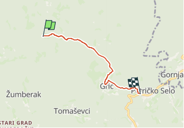
7 km | 11,3 km-effort
2h 34min
![](https://static1.geolcdn.com/siteimages/upload/files/16400158638029165_repeat_loop_refresh_sync_direction_icon.png)
Neen
![Tocht Te voet - Vodice - Ječmište - Photo](https://media.geolcdn.com/t/375/260/4b8d24c8-9453-45e6-933b-732f6705d98c.jpeg&format=jpg&maxdim=2)
![Te voet Te voet](https://static1.geolcdn.com/sitytour/trail-icons/100.png)
Vodice - Ječmište
Te voet
Gemakkelijk
,
Onbekend,
Zagrebačka županija,
Croatia
![](/images/other/stat-length.png)
4,1 km | 6,9 km-effort
1h 34min
![](https://static1.geolcdn.com/siteimages/upload/files/16400158638029165_repeat_loop_refresh_sync_direction_icon.png)
Neen
![Tocht Te voet - Sošice - Boići - Sv. Gera - Photo](https://media.geolcdn.com/t/375/260/4b8d24c8-9453-45e6-933b-732f6705d98c.jpeg&format=jpg&maxdim=2)
![Te voet Te voet](https://static1.geolcdn.com/sitytour/trail-icons/100.png)
Sošice - Boići - Sv. Gera
Te voet
Gemakkelijk
,
Onbekend,
Zagrebačka županija,
Croatia
![](/images/other/stat-length.png)
6,5 km | 12,7 km-effort
2h 53min
![](https://static1.geolcdn.com/siteimages/upload/files/16400158638029165_repeat_loop_refresh_sync_direction_icon.png)
Neen
![Tocht Te voet - Slap Sopot - Pliješ - Photo](https://media.geolcdn.com/t/375/260/4b8d24c8-9453-45e6-933b-732f6705d98c.jpeg&format=jpg&maxdim=2)
![Te voet Te voet](https://static1.geolcdn.com/sitytour/trail-icons/100.png)
Slap Sopot - Pliješ
Te voet
Gemakkelijk
,
Onbekend,
Zagrebačka županija,
Croatia
![](/images/other/stat-length.png)
3,5 km | 5,8 km-effort
1h 19min
![](https://static1.geolcdn.com/siteimages/upload/files/16400158638029165_repeat_loop_refresh_sync_direction_icon.png)
Neen
![Tocht Te voet - Bernardići - Slap Sopot - Photo](https://media.geolcdn.com/t/375/260/4b8d24c8-9453-45e6-933b-732f6705d98c.jpeg&format=jpg&maxdim=2)
![Te voet Te voet](https://static1.geolcdn.com/sitytour/trail-icons/100.png)
Bernardići - Slap Sopot
Te voet
Gemakkelijk
,
Onbekend,
Zagrebačka županija,
Croatia
![](/images/other/stat-length.png)
7,5 km | 11,2 km-effort
2h 33min
![](https://static1.geolcdn.com/siteimages/upload/files/16400158638029165_repeat_loop_refresh_sync_direction_icon.png)
Neen
![Tocht Te voet - Sošice - Sekulići - Photo](https://media.geolcdn.com/t/375/260/ext.jpg?maxdim=2&url=https%3A%2F%2Fstatic1.geolcdn.com%2Fsiteimages%2Fupload%2Ffiles%2F1545311037marcheuse_200dpi.jpg)
![Te voet Te voet](https://static1.geolcdn.com/sitytour/trail-icons/100.png)
Sošice - Sekulići
Te voet
Gemakkelijk
,
Onbekend,
Zagrebačka županija,
Croatia
![](/images/other/stat-length.png)
7,5 km | 11,5 km-effort
2h 36min
![](https://static1.geolcdn.com/siteimages/upload/files/16400158638029165_repeat_loop_refresh_sync_direction_icon.png)
Neen
![Tocht Te voet - Bernardići - Kalje - Photo](https://media.geolcdn.com/t/375/260/ext.jpg?maxdim=2&url=https%3A%2F%2Fstatic1.geolcdn.com%2Fsiteimages%2Fupload%2Ffiles%2F1545311037marcheuse_200dpi.jpg)
![Te voet Te voet](https://static1.geolcdn.com/sitytour/trail-icons/100.png)
Bernardići - Kalje
Te voet
Gemakkelijk
,
Onbekend,
Zagrebačka županija,
Croatia
![](/images/other/stat-length.png)
5,2 km | 7,8 km-effort
1h 46min
![](https://static1.geolcdn.com/siteimages/upload/files/16400158638029165_repeat_loop_refresh_sync_direction_icon.png)
Neen