![](/images/other/stat-length.png)
![Tocht Te voet Bozkov - NS Údolím Vošmendy - Photo](https://media.geolcdn.com/t/1900/400/b95f7973-14a9-4ebe-8f71-115789124244.jpeg&format=pjpeg&maxdim=2)
NS Údolím Vošmendy
SityTrail - itinéraires balisés pédestres
Tous les sentiers balisés d’Europe GUIDE+
![Lengte](/images/other/stat-length.png)
Lengte
4,3 km
![Max. hoogte](https://static1.geolcdn.com/siteimages/upload/files/1508320355ic_sort_altitude_max_24dp.png)
Max. hoogte
515 m
![Positief hoogteverschil](https://static1.geolcdn.com/siteimages/upload/files/1508320355ic_sort_den_pos_24dp.png)
Positief hoogteverschil
101 m
![Km-Effort](/images/other/stat-length.png)
Km-Effort
5,7 km
![Min. hoogte](https://static1.geolcdn.com/siteimages/upload/files/1508320355ic_sort_altitude_min_24dp.png)
Min. hoogte
437 m
![Negatief hoogteverschil](https://static1.geolcdn.com/siteimages/upload/files/1508320355ic_sort_den_neg_24dp.png)
Negatief hoogteverschil
99 m
![Boucle](https://static1.geolcdn.com/siteimages/upload/files/16400158638029165_repeat_loop_refresh_sync_direction_icon.png)
Boucle
Neen
Markering
Datum van aanmaak :
2025-02-07 10:32:15.586
Laatste wijziging :
2025-02-07 10:32:15.586
![Te voet](https://static1.geolcdn.com/sitytour/trail-icons/100.png)
1h17
Moeilijkheid : Gemakkelijk
![Scan deze QR-code om de tocht te openen in de SityTrail-applicatie](https://capi.geolives.com/qq0zvz2zws4bq2lad0pu/sitytour/trails/4345294/qr.png?size=200)
Gratisgps-wandelapplicatie
Over ons
Tocht Te voet van 4,3 km beschikbaar op Noordoost, Liberecký kraj, Bozkov. Deze tocht wordt voorgesteld door SityTrail - itinéraires balisés pédestres.
Beschrijving
Tocht aangemaakt door cz:KČT.
Plaatsbepaling
Land:
Czech Republic
Regio :
Noordoost
Departement/Provincie :
Liberecký kraj
Gemeente :
Bozkov
Locatie:
Unknown
Vertrek:(Dec)
Vertrek:(UTM)
524084 ; 5610136 (33U) N.
Opmerkingen
Wandeltochten in de omgeving
![Tocht Te voet Semily - [Ž] Semily - Sejkorská kaple - Bitouchov - Photo](https://media.geolcdn.com/t/375/260/ad273ffb-8712-4976-94a1-7a2514a4e8d8.jpeg&format=jpg&maxdim=2)
![Te voet Te voet](https://static1.geolcdn.com/sitytour/trail-icons/100.png)
[Ž] Semily - Sejkorská kaple - Bitouchov
Te voet
Gemakkelijk
Semily,
Noordoost,
Liberecký kraj,
Czech Republic
![](/images/other/stat-length.png)
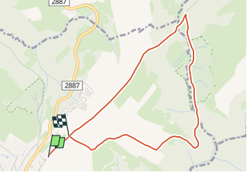
8,1 km | 11 km-effort
2h 29min
![](https://static1.geolcdn.com/siteimages/upload/files/16400158638029165_repeat_loop_refresh_sync_direction_icon.png)
Neen
![Tocht Te voet Semily - [M] Semily - Nouzov - Photo](https://media.geolcdn.com/t/375/260/ad273ffb-8712-4976-94a1-7a2514a4e8d8.jpeg&format=jpg&maxdim=2)
![Te voet Te voet](https://static1.geolcdn.com/sitytour/trail-icons/100.png)
[M] Semily - Nouzov
Te voet
Gemakkelijk
Semily,
Noordoost,
Liberecký kraj,
Czech Republic
![](/images/other/stat-length.png)
5,9 km | 8,6 km-effort
1h 56min
![](https://static1.geolcdn.com/siteimages/upload/files/16400158638029165_repeat_loop_refresh_sync_direction_icon.png)
Neen
![Tocht Te voet Zlatá Olešnice - [Ž] Semily - Navarov - Photo](https://media.geolcdn.com/t/375/260/5523b8f3-209a-4272-a9d5-33fce53a0bdf.jpeg&format=jpg&maxdim=2)
![Te voet Te voet](https://static1.geolcdn.com/sitytour/trail-icons/100.png)
[Ž] Semily - Navarov
Te voet
Gemakkelijk
Zlatá Olešnice,
Noordoost,
Liberecký kraj,
Czech Republic
![](/images/other/stat-length.png)
11,4 km | 15,7 km-effort
3h 34min
![](https://static1.geolcdn.com/siteimages/upload/files/16400158638029165_repeat_loop_refresh_sync_direction_icon.png)
Neen
![Tocht Te voet Zlatá Olešnice - [Z] Vysoké nad Jizerou - Navarov - Photo](https://media.geolcdn.com/t/375/260/bb77414f-83f5-400f-80e3-784a7ebc3b43.jpeg&format=jpg&maxdim=2)
![Te voet Te voet](https://static1.geolcdn.com/sitytour/trail-icons/100.png)
[Z] Vysoké nad Jizerou - Navarov
Te voet
Gemakkelijk
Zlatá Olešnice,
Noordoost,
Liberecký kraj,
Czech Republic
![](/images/other/stat-length.png)
7,2 km | 10,8 km-effort
2h 26min
![](https://static1.geolcdn.com/siteimages/upload/files/16400158638029165_repeat_loop_refresh_sync_direction_icon.png)
Neen
![Tocht Te voet Chuchelna - [Ž] Semily - U Krkavčí skály - Photo](https://media.geolcdn.com/t/375/260/a7e8cadb-e577-4017-bd0b-837334638646.jpeg&format=jpg&maxdim=2)
![Te voet Te voet](https://static1.geolcdn.com/sitytour/trail-icons/100.png)
[Ž] Semily - U Krkavčí skály
Te voet
Gemakkelijk
Chuchelna,
Noordoost,
Liberecký kraj,
Czech Republic
![](/images/other/stat-length.png)
3,5 km | 4 km-effort
54min
![](https://static1.geolcdn.com/siteimages/upload/files/16400158638029165_repeat_loop_refresh_sync_direction_icon.png)
Neen
![Tocht Te voet Roztoky u Semil - [Ž] Poniklá - Roztoky u Semil - Photo](https://media.geolcdn.com/t/375/260/84ad4702-43b8-450d-902b-9f2518462633.jpeg&format=jpg&maxdim=2)
![Te voet Te voet](https://static1.geolcdn.com/sitytour/trail-icons/100.png)
[Ž] Poniklá - Roztoky u Semil
Te voet
Gemakkelijk
Roztoky u Semil,
Noordoost,
Liberecký kraj,
Czech Republic
![](/images/other/stat-length.png)
10,4 km | 14,6 km-effort
3h 19min
![](https://static1.geolcdn.com/siteimages/upload/files/16400158638029165_repeat_loop_refresh_sync_direction_icon.png)
Neen
![Tocht Te voet Vysoké nad Jizerou - [Ž] Vysocký okruh - Photo](https://media.geolcdn.com/t/375/260/24e2f286-3c11-49f7-b19e-01f6a5b461ca.jpeg&format=jpg&maxdim=2)
![Te voet Te voet](https://static1.geolcdn.com/sitytour/trail-icons/100.png)
[Ž] Vysocký okruh
Te voet
Gemakkelijk
Vysoké nad Jizerou,
Noordoost,
Liberecký kraj,
Czech Republic
![](/images/other/stat-length.png)
10,4 km | 14,1 km-effort
3h 12min
![](https://static1.geolcdn.com/siteimages/upload/files/16400158638029165_repeat_loop_refresh_sync_direction_icon.png)
Ja
![Tocht Te voet Semily - NS Údolím Jizery - Riegrova stezka - Photo](https://media.geolcdn.com/t/375/260/f28457de-1dd4-4d17-adda-244d66d45df5.jpeg&format=jpg&maxdim=2)
![Te voet Te voet](https://static1.geolcdn.com/sitytour/trail-icons/100.png)
NS Údolím Jizery - Riegrova stezka
Te voet
Gemakkelijk
Semily,
Noordoost,
Liberecký kraj,
Czech Republic
![](/images/other/stat-length.png)
3,7 km | 5,2 km-effort
1h 10min
![](https://static1.geolcdn.com/siteimages/upload/files/16400158638029165_repeat_loop_refresh_sync_direction_icon.png)
Neen
![Tocht Te voet Semily - [Z] Jilemnice - Vrchlabí - Photo](https://media.geolcdn.com/t/375/260/ext.jpg?maxdim=2&url=https%3A%2F%2Fstatic1.geolcdn.com%2Fsiteimages%2Fupload%2Ffiles%2F1545311037marcheuse_200dpi.jpg)
![Te voet Te voet](https://static1.geolcdn.com/sitytour/trail-icons/100.png)
[Z] Jilemnice - Vrchlabí
Te voet
Moeilijk
Semily,
Noordoost,
Liberecký kraj,
Czech Republic
![](/images/other/stat-length.png)
25 km | 34 km-effort
7h 45min
![](https://static1.geolcdn.com/siteimages/upload/files/16400158638029165_repeat_loop_refresh_sync_direction_icon.png)
Neen