


3,1 km | 4,2 km-effort
![Tocht Te voet Chuchelna - [Ž] Semily - U Krkavčí skály - Photo](https://media.geolcdn.com/t/1900/400/a7e8cadb-e577-4017-bd0b-837334638646.jpeg&format=pjpeg&maxdim=2)

Tous les sentiers balisés d’Europe GUIDE+


Gratisgps-wandelapplicatie
 SityTrail
IGN / Geografische instituten
SityTrail World
De wereld gaat voor u open
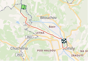
Tocht Te voet van 3,5 km beschikbaar op Noordoost, Liberecký kraj, Chuchelna. Deze tocht wordt voorgesteld door SityTrail - itinéraires balisés pédestres.
Tocht aangemaakt door cz:KČT.
![Tocht Te voet Chuchelna - [Ž] Semily - U Krkavčí skály - Photo 1](https://media.geolcdn.com/t/2048/auto/b7d2e66b-262e-490f-a076-30fc6859e868.jpeg&format=jpg&maxdim=0 "Tocht Te voet Chuchelna - [Ž] Semily - U Krkavčí skály - Photo 1")
![Tocht Te voet Chuchelna - [Ž] Semily - U Krkavčí skály - Photo 2](https://media.geolcdn.com/t/2048/auto/66fd691d-64f0-4566-9cd5-56ec34699942.jpeg&format=jpg&maxdim=0 "Tocht Te voet Chuchelna - [Ž] Semily - U Krkavčí skály - Photo 2")
![Tocht Te voet Chuchelna - [Ž] Semily - U Krkavčí skály - Photo 3](https://media.geolcdn.com/t/2048/auto/110ef1f1-dad7-471f-a71c-4411e02b2e91.jpeg&format=jpg&maxdim=0 "Tocht Te voet Chuchelna - [Ž] Semily - U Krkavčí skály - Photo 3")
![Tocht Te voet Chuchelna - [Ž] Semily - U Krkavčí skály - Photo 4](https://media.geolcdn.com/t/2048/auto/8839127d-d2fa-4e96-b7a6-c506b1b589a2.jpeg&format=jpg&maxdim=0 "Tocht Te voet Chuchelna - [Ž] Semily - U Krkavčí skály - Photo 4")
![Tocht Te voet Chuchelna - [Ž] Semily - U Krkavčí skály - Photo 5](https://media.geolcdn.com/t/2048/auto/ef80c3f9-f63d-42f9-acd0-7c4f04952d34.jpeg&format=jpg&maxdim=0 "Tocht Te voet Chuchelna - [Ž] Semily - U Krkavčí skály - Photo 5")
![Tocht Te voet Chuchelna - [Ž] Semily - U Krkavčí skály - Photo 6](https://media.geolcdn.com/t/2048/auto/57592fd9-a4a6-488b-a21d-790f732b26c2.jpeg&format=jpg&maxdim=0 "Tocht Te voet Chuchelna - [Ž] Semily - U Krkavčí skály - Photo 6")
![Tocht Te voet Chuchelna - [Ž] Semily - U Krkavčí skály - Photo 7](https://media.geolcdn.com/t/2048/auto/c6f94b48-3a0f-47e8-81be-0ac4a1a21ee6.jpeg&format=jpg&maxdim=0 "Tocht Te voet Chuchelna - [Ž] Semily - U Krkavčí skály - Photo 7")
![Tocht Te voet Chuchelna - [Ž] Semily - U Krkavčí skály - Photo 8](https://media.geolcdn.com/t/2048/auto/83359f2f-0cc2-4ff4-b77c-14bd840b2cc5.jpeg&format=jpg&maxdim=0 "Tocht Te voet Chuchelna - [Ž] Semily - U Krkavčí skály - Photo 8")
![Tocht Te voet Chuchelna - [Ž] Semily - U Krkavčí skály - Photo 9](https://media.geolcdn.com/t/2048/auto/d6c00656-56a2-4fec-9906-861ba6b89ece.jpeg&format=jpg&maxdim=0 "Tocht Te voet Chuchelna - [Ž] Semily - U Krkavčí skály - Photo 9")
![Tocht Te voet Chuchelna - [Ž] Semily - U Krkavčí skály - Photo 10](https://media.geolcdn.com/t/2048/auto/a7e8cadb-e577-4017-bd0b-837334638646.jpeg&format=jpg&maxdim=0 "Tocht Te voet Chuchelna - [Ž] Semily - U Krkavčí skály - Photo 10")
![Tocht Te voet Chuchelna - [Ž] Tatobity (vodojem) - Kozákov - Photo](https://media.geolcdn.com/t/375/260/60a9145e-607c-4ea0-a933-69a7b1a00525.jpeg&format=jpg&maxdim=2)
Te voet
Te voet
![Tocht Te voet Semily - [Ž] Semily - Sejkorská kaple - Bitouchov - Photo](https://media.geolcdn.com/t/375/260/ad273ffb-8712-4976-94a1-7a2514a4e8d8.jpeg&format=jpg&maxdim=2)
Te voet
Te voet
Te voet
![Tocht Te voet Roztoky u Semil - [Ž] Poniklá - Roztoky u Semil - Photo](https://media.geolcdn.com/t/375/260/84ad4702-43b8-450d-902b-9f2518462633.jpeg&format=jpg&maxdim=2)
Te voet
![Tocht Te voet Železný Brod - [Ž] Železný Brod - Haratina - okruh - Photo](https://media.geolcdn.com/t/375/260/8202f669-ebe5-4de0-ba9e-f735bb27a1ff.jpeg&format=jpg&maxdim=2)
Te voet
![Tocht Te voet Železný Brod - [Z] Berany - Hrubá Horka - Photo](https://media.geolcdn.com/t/375/260/85b5fcbf-013c-4152-8474-e3ec21cfb00d.jpeg&format=jpg&maxdim=2)
Te voet
![Tocht Te voet Železný Brod - [M] Železný Brod - Bozkov - Photo](https://media.geolcdn.com/t/375/260/adb30047-d63e-4dac-9668-d1ce55b1c46f.jpeg&format=jpg&maxdim=2)
Te voet