


4,3 km | 5,7 km-effort
![Tocht Te voet Roztoky u Semil - [Ž] Poniklá - Roztoky u Semil - Photo](https://media.geolcdn.com/t/1900/400/84ad4702-43b8-450d-902b-9f2518462633.jpeg&format=pjpeg&maxdim=2)

Tous les sentiers balisés d’Europe GUIDE+


Gratisgps-wandelapplicatie
 SityTrail
IGN / Geografische instituten
SityTrail World
De wereld gaat voor u open
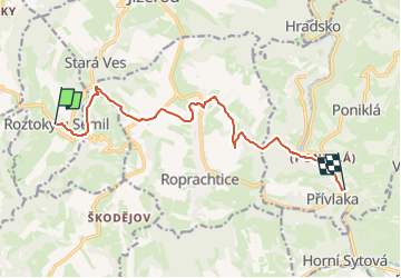
Tocht Te voet van 10,4 km beschikbaar op Noordoost, Liberecký kraj, Roztoky u Semil. Deze tocht wordt voorgesteld door SityTrail - itinéraires balisés pédestres.
Tocht aangemaakt door cz:KČT.
![Tocht Te voet Roztoky u Semil - [Ž] Poniklá - Roztoky u Semil - Photo 1](https://media.geolcdn.com/t/2048/auto/88f572d5-f5ce-40b4-aea8-19ed8a1a2a61.jpeg&format=jpg&maxdim=0 "Tocht Te voet Roztoky u Semil - [Ž] Poniklá - Roztoky u Semil - Photo 1")
![Tocht Te voet Roztoky u Semil - [Ž] Poniklá - Roztoky u Semil - Photo 2](https://media.geolcdn.com/t/2048/auto/fe283852-cbbd-4d3e-af8a-509c400f6f7f.jpeg&format=jpg&maxdim=0 "Tocht Te voet Roztoky u Semil - [Ž] Poniklá - Roztoky u Semil - Photo 2")
![Tocht Te voet Roztoky u Semil - [Ž] Poniklá - Roztoky u Semil - Photo 3](https://media.geolcdn.com/t/2048/auto/fe82a4c8-0bc5-41e2-9bc8-d5ec9b65f1b1.jpeg&format=jpg&maxdim=0 "Tocht Te voet Roztoky u Semil - [Ž] Poniklá - Roztoky u Semil - Photo 3")
![Tocht Te voet Roztoky u Semil - [Ž] Poniklá - Roztoky u Semil - Photo 4](https://media.geolcdn.com/t/2048/auto/a2fd803c-1958-45d3-90ac-51e5e6a92bfe.jpeg&format=jpg&maxdim=0 "Tocht Te voet Roztoky u Semil - [Ž] Poniklá - Roztoky u Semil - Photo 4")
![Tocht Te voet Roztoky u Semil - [Ž] Poniklá - Roztoky u Semil - Photo 5](https://media.geolcdn.com/t/2048/auto/af437c7f-5254-4e49-bc00-34829ebbbf74.jpeg&format=jpg&maxdim=0 "Tocht Te voet Roztoky u Semil - [Ž] Poniklá - Roztoky u Semil - Photo 5")
![Tocht Te voet Roztoky u Semil - [Ž] Poniklá - Roztoky u Semil - Photo 6](https://media.geolcdn.com/t/2048/auto/c6f05cf0-b43f-43fc-a37f-07790a7927bc.jpeg&format=jpg&maxdim=0 "Tocht Te voet Roztoky u Semil - [Ž] Poniklá - Roztoky u Semil - Photo 6")
![Tocht Te voet Roztoky u Semil - [Ž] Poniklá - Roztoky u Semil - Photo 7](https://media.geolcdn.com/t/2048/auto/9296d136-4964-422a-9cdc-8410f66506d6.jpeg&format=jpg&maxdim=0 "Tocht Te voet Roztoky u Semil - [Ž] Poniklá - Roztoky u Semil - Photo 7")
![Tocht Te voet Roztoky u Semil - [Ž] Poniklá - Roztoky u Semil - Photo 8](https://media.geolcdn.com/t/2048/auto/0ae25bdd-6b39-4fcb-a9bd-f31272277aed.jpeg&format=jpg&maxdim=0 "Tocht Te voet Roztoky u Semil - [Ž] Poniklá - Roztoky u Semil - Photo 8")
![Tocht Te voet Roztoky u Semil - [Ž] Poniklá - Roztoky u Semil - Photo 9](https://media.geolcdn.com/t/2048/auto/f3ef7404-acf7-4b3f-b885-ba5b675fed56.jpeg&format=jpg&maxdim=0 "Tocht Te voet Roztoky u Semil - [Ž] Poniklá - Roztoky u Semil - Photo 9")
![Tocht Te voet Roztoky u Semil - [Ž] Poniklá - Roztoky u Semil - Photo 10](https://media.geolcdn.com/t/2048/auto/84ad4702-43b8-450d-902b-9f2518462633.jpeg&format=jpg&maxdim=0 "Tocht Te voet Roztoky u Semil - [Ž] Poniklá - Roztoky u Semil - Photo 10")
Te voet
![Tocht Te voet Zlatá Olešnice - [Ž] Semily - Navarov - Photo](https://media.geolcdn.com/t/375/260/5523b8f3-209a-4272-a9d5-33fce53a0bdf.jpeg&format=jpg&maxdim=2)
Te voet
![Tocht Te voet Zlatá Olešnice - [Z] Vysoké nad Jizerou - Navarov - Photo](https://media.geolcdn.com/t/375/260/bb77414f-83f5-400f-80e3-784a7ebc3b43.jpeg&format=jpg&maxdim=2)
Te voet
![Tocht Te voet Chuchelna - [Ž] Semily - U Krkavčí skály - Photo](https://media.geolcdn.com/t/375/260/a7e8cadb-e577-4017-bd0b-837334638646.jpeg&format=jpg&maxdim=2)
Te voet
![Tocht Te voet Vysoké nad Jizerou - [Ž] Vysocký okruh - Photo](https://media.geolcdn.com/t/375/260/24e2f286-3c11-49f7-b19e-01f6a5b461ca.jpeg&format=jpg&maxdim=2)
Te voet
Te voet
![Tocht Te voet Jablonec nad Jizerou - [Ž] Jablonec n. Jiz. - Hvězda - Photo](https://media.geolcdn.com/t/375/260/fe4e1de7-5ae3-412c-a3b9-857e0baa941f.jpeg&format=jpg&maxdim=2)
Te voet