


15,2 km | 19,4 km-effort
![Tocht Te voet Krásný Dvůr - [Č] 0378 Červený okruh - Photo](https://media.geolcdn.com/t/1900/400/a2237453-12a7-4014-acf3-8544ee4986a4.jpeg&format=pjpeg&maxdim=2)

Tous les sentiers balisés d’Europe GUIDE+


Gratisgps-wandelapplicatie
 SityTrail
IGN / Geografische instituten
SityTrail World
De wereld gaat voor u open
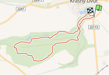
Tocht Te voet van 4,6 km beschikbaar op Noordwest, Ústecký kraj, Krásný Dvůr. Deze tocht wordt voorgesteld door SityTrail - itinéraires balisés pédestres.
Tocht aangemaakt door cz:KČT.
![Tocht Te voet Krásný Dvůr - [Č] 0378 Červený okruh - Photo 1](https://media.geolcdn.com/t/2048/auto/7579931a-8b18-442e-8a91-8da509451eef.jpeg&format=jpg&maxdim=0 "Tocht Te voet Krásný Dvůr - [Č] 0378 Červený okruh - Photo 1")
![Tocht Te voet Krásný Dvůr - [Č] 0378 Červený okruh - Photo 2](https://media.geolcdn.com/t/2048/auto/2a99d8af-2fd0-4287-b73a-b4840235a45e.jpeg&format=jpg&maxdim=0 "Tocht Te voet Krásný Dvůr - [Č] 0378 Červený okruh - Photo 2")
![Tocht Te voet Krásný Dvůr - [Č] 0378 Červený okruh - Photo 3](https://media.geolcdn.com/t/2048/auto/2edebb81-5f62-4b22-a260-7ab5cd5387fa.jpeg&format=jpg&maxdim=0 "Tocht Te voet Krásný Dvůr - [Č] 0378 Červený okruh - Photo 3")
![Tocht Te voet Krásný Dvůr - [Č] 0378 Červený okruh - Photo 4](https://media.geolcdn.com/t/2048/auto/9c346a15-85f9-4720-9cd8-cb958e1d8d58.jpeg&format=jpg&maxdim=0 "Tocht Te voet Krásný Dvůr - [Č] 0378 Červený okruh - Photo 4")
![Tocht Te voet Krásný Dvůr - [Č] 0378 Červený okruh - Photo 5](https://media.geolcdn.com/t/2048/auto/4ad55c99-988a-4c43-a2c8-19a6393a7ba9.jpeg&format=jpg&maxdim=0 "Tocht Te voet Krásný Dvůr - [Č] 0378 Červený okruh - Photo 5")
![Tocht Te voet Krásný Dvůr - [Č] 0378 Červený okruh - Photo 6](https://media.geolcdn.com/t/2048/auto/54d4829f-777c-4ace-9abe-d97a664d25f7.jpeg&format=jpg&maxdim=0 "Tocht Te voet Krásný Dvůr - [Č] 0378 Červený okruh - Photo 6")
![Tocht Te voet Krásný Dvůr - [Č] 0378 Červený okruh - Photo 7](https://media.geolcdn.com/t/2048/auto/1f943d82-848e-4f39-adc4-426d89bd8f32.jpeg&format=jpg&maxdim=0 "Tocht Te voet Krásný Dvůr - [Č] 0378 Červený okruh - Photo 7")
![Tocht Te voet Krásný Dvůr - [Č] 0378 Červený okruh - Photo 8](https://media.geolcdn.com/t/2048/auto/c90a4526-69cf-48b6-9ac2-ce2a06334b2a.jpeg&format=jpg&maxdim=0 "Tocht Te voet Krásný Dvůr - [Č] 0378 Červený okruh - Photo 8")
![Tocht Te voet Krásný Dvůr - [Č] 0378 Červený okruh - Photo 9](https://media.geolcdn.com/t/2048/auto/286f0afc-9604-400b-9f84-b966c2dd2126.jpeg&format=jpg&maxdim=0 "Tocht Te voet Krásný Dvůr - [Č] 0378 Červený okruh - Photo 9")
![Tocht Te voet Krásný Dvůr - [Č] 0378 Červený okruh - Photo 10](https://media.geolcdn.com/t/2048/auto/a2237453-12a7-4014-acf3-8544ee4986a4.jpeg&format=jpg&maxdim=0 "Tocht Te voet Krásný Dvůr - [Č] 0378 Červený okruh - Photo 10")
![Tocht Te voet Kryry - [M] Nepomyšl - Kryry - Photo](https://media.geolcdn.com/t/375/260/a2408f13-d402-4160-be99-95020e040a2f.jpeg&format=jpg&maxdim=2)
Te voet
Te voet
Te voet
Te voet
Te voet
Te voet
Te voet

Te voet