


5,2 km | 6,1 km-effort
![Tocht Te voet Řehlovice - [Ž] 6903 Bořislav žst. - Bílka - Photo](https://media.geolcdn.com/t/1900/400/20fad6c0-6847-4731-ac6e-3053bcff3f73.jpeg&format=pjpeg&maxdim=2)

Tous les sentiers balisés d’Europe GUIDE+


Gratisgps-wandelapplicatie
 SityTrail
IGN / Geografische instituten
SityTrail World
De wereld gaat voor u open
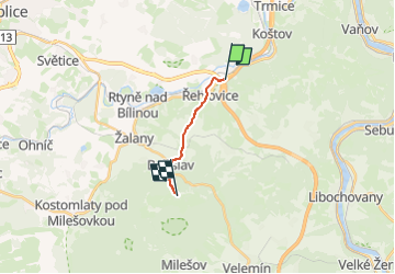
Tocht Te voet van 6,8 km beschikbaar op Noordwest, Ústecký kraj, Řehlovice. Deze tocht wordt voorgesteld door SityTrail - itinéraires balisés pédestres.
Tocht aangemaakt door cz:KČT.
![Tocht Te voet Řehlovice - [Ž] 6903 Bořislav žst. - Bílka - Photo 1](https://media.geolcdn.com/t/2048/auto/4d375400-4269-466e-9cb4-c15e75ec964d.jpeg&format=jpg&maxdim=0 "Tocht Te voet Řehlovice - [Ž] 6903 Bořislav žst. - Bílka - Photo 1")
![Tocht Te voet Řehlovice - [Ž] 6903 Bořislav žst. - Bílka - Photo 2](https://media.geolcdn.com/t/2048/auto/64172fef-bc1d-4405-82c1-76166de1ec52.jpeg&format=jpg&maxdim=0 "Tocht Te voet Řehlovice - [Ž] 6903 Bořislav žst. - Bílka - Photo 2")
![Tocht Te voet Řehlovice - [Ž] 6903 Bořislav žst. - Bílka - Photo 3](https://media.geolcdn.com/t/2048/auto/1201b577-97a6-4c55-a61a-3734ba53b837.jpeg&format=jpg&maxdim=0 "Tocht Te voet Řehlovice - [Ž] 6903 Bořislav žst. - Bílka - Photo 3")
![Tocht Te voet Řehlovice - [Ž] 6903 Bořislav žst. - Bílka - Photo 4](https://media.geolcdn.com/t/2048/auto/187593a6-d71c-4245-890c-2457dc7c3b4e.jpeg&format=jpg&maxdim=0 "Tocht Te voet Řehlovice - [Ž] 6903 Bořislav žst. - Bílka - Photo 4")
![Tocht Te voet Řehlovice - [Ž] 6903 Bořislav žst. - Bílka - Photo 5](https://media.geolcdn.com/t/2048/auto/fd757034-0534-4836-8f33-cfbc9f6ec17f.jpeg&format=jpg&maxdim=0 "Tocht Te voet Řehlovice - [Ž] 6903 Bořislav žst. - Bílka - Photo 5")
![Tocht Te voet Řehlovice - [Ž] 6903 Bořislav žst. - Bílka - Photo 6](https://media.geolcdn.com/t/2048/auto/b28363cc-66c0-4d8d-b8ee-4f68b340892a.jpeg&format=jpg&maxdim=0 "Tocht Te voet Řehlovice - [Ž] 6903 Bořislav žst. - Bílka - Photo 6")
![Tocht Te voet Řehlovice - [Ž] 6903 Bořislav žst. - Bílka - Photo 7](https://media.geolcdn.com/t/2048/auto/c8e39112-ff48-4685-845b-a6867b652a5e.jpeg&format=jpg&maxdim=0 "Tocht Te voet Řehlovice - [Ž] 6903 Bořislav žst. - Bílka - Photo 7")
![Tocht Te voet Řehlovice - [Ž] 6903 Bořislav žst. - Bílka - Photo 8](https://media.geolcdn.com/t/2048/auto/2c0cf36c-0a02-41a4-b3fe-c2f09f5fa7d9.jpeg&format=jpg&maxdim=0 "Tocht Te voet Řehlovice - [Ž] 6903 Bořislav žst. - Bílka - Photo 8")
![Tocht Te voet Řehlovice - [Ž] 6903 Bořislav žst. - Bílka - Photo 9](https://media.geolcdn.com/t/2048/auto/20fad6c0-6847-4731-ac6e-3053bcff3f73.jpeg&format=jpg&maxdim=0 "Tocht Te voet Řehlovice - [Ž] 6903 Bořislav žst. - Bílka - Photo 9")
![Tocht Te voet Řehlovice - [Ž] 6903 Bořislav žst. - Bílka - Photo 10](https://media.geolcdn.com/t/2048/auto/871500c8-08f8-4bd8-afb2-a7c1ffca28bf.jpeg&format=jpg&maxdim=0 "Tocht Te voet Řehlovice - [Ž] 6903 Bořislav žst. - Bílka - Photo 10")
![Tocht Te voet Řehlovice - [Č] Stadice - Trmice - Photo](https://media.geolcdn.com/t/375/260/8fa696a3-787f-46bb-a957-760407562257.jpeg&format=jpg&maxdim=2)
Te voet

Fiets