


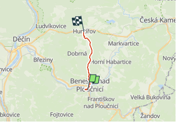

4,1 km | 7,4 km-effort
![Tocht Te voet Benešov nad Ploučnicí - [Ž] Benešov nad Ploučnicí - Huntířov - Photo](https://media.geolcdn.com/t/1900/400/bbcc4ada-53a6-4f1a-8a2a-532b77b1123c.jpeg&format=pjpeg&maxdim=2)

Tous les sentiers balisés d’Europe GUIDE+


Gratisgps-wandelapplicatie
 SityTrail
IGN / Geografische instituten
SityTrail World
De wereld gaat voor u open
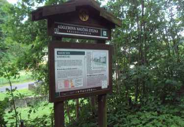
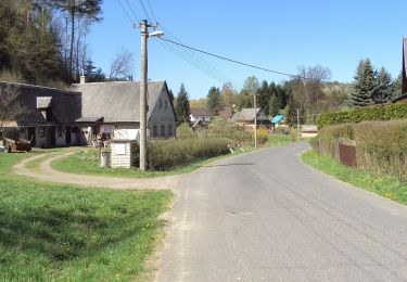
Tocht Te voet van 7,3 km beschikbaar op Noordwest, Ústecký kraj, Benešov nad Ploučnicí. Deze tocht wordt voorgesteld door SityTrail - itinéraires balisés pédestres.
Tocht aangemaakt door cz:KČT.
![Tocht Te voet Benešov nad Ploučnicí - [Ž] Benešov nad Ploučnicí - Huntířov - Photo 1](https://media.geolcdn.com/t/2048/auto/0b8b5081-2fd7-40f8-a0b6-f8814d579b21.jpeg&format=jpg&maxdim=0 "Tocht Te voet Benešov nad Ploučnicí - [Ž] Benešov nad Ploučnicí - Huntířov - Photo 1")
![Tocht Te voet Benešov nad Ploučnicí - [Ž] Benešov nad Ploučnicí - Huntířov - Photo 2](https://media.geolcdn.com/t/2048/auto/bacfd78f-c4f1-4c20-8f01-7aafbeecb7b7.jpeg&format=jpg&maxdim=0 "Tocht Te voet Benešov nad Ploučnicí - [Ž] Benešov nad Ploučnicí - Huntířov - Photo 2")
![Tocht Te voet Benešov nad Ploučnicí - [Ž] Benešov nad Ploučnicí - Huntířov - Photo 3](https://media.geolcdn.com/t/2048/auto/a87212e4-e366-427e-ba8d-ece34b186b5d.jpeg&format=jpg&maxdim=0 "Tocht Te voet Benešov nad Ploučnicí - [Ž] Benešov nad Ploučnicí - Huntířov - Photo 3")
![Tocht Te voet Benešov nad Ploučnicí - [Ž] Benešov nad Ploučnicí - Huntířov - Photo 4](https://media.geolcdn.com/t/2048/auto/48f34c19-eee0-49c9-9b95-e95856f2339e.jpeg&format=jpg&maxdim=0 "Tocht Te voet Benešov nad Ploučnicí - [Ž] Benešov nad Ploučnicí - Huntířov - Photo 4")
![Tocht Te voet Benešov nad Ploučnicí - [Ž] Benešov nad Ploučnicí - Huntířov - Photo 5](https://media.geolcdn.com/t/2048/auto/6be8e032-803d-4083-94f4-d91c6cc4d14c.jpeg&format=jpg&maxdim=0 "Tocht Te voet Benešov nad Ploučnicí - [Ž] Benešov nad Ploučnicí - Huntířov - Photo 5")
![Tocht Te voet Benešov nad Ploučnicí - [Ž] Benešov nad Ploučnicí - Huntířov - Photo 6](https://media.geolcdn.com/t/2048/auto/a80d60cb-bb30-40f6-b880-0f3b641241dd.jpeg&format=jpg&maxdim=0 "Tocht Te voet Benešov nad Ploučnicí - [Ž] Benešov nad Ploučnicí - Huntířov - Photo 6")
![Tocht Te voet Benešov nad Ploučnicí - [Ž] Benešov nad Ploučnicí - Huntířov - Photo 7](https://media.geolcdn.com/t/2048/auto/5c42610c-c72b-4109-b6cf-466aa803e3d8.jpeg&format=jpg&maxdim=0 "Tocht Te voet Benešov nad Ploučnicí - [Ž] Benešov nad Ploučnicí - Huntířov - Photo 7")
![Tocht Te voet Benešov nad Ploučnicí - [Ž] Benešov nad Ploučnicí - Huntířov - Photo 8](https://media.geolcdn.com/t/2048/auto/d2c4b9e5-0de2-4773-a61a-763a4eecd106.jpeg&format=jpg&maxdim=0 "Tocht Te voet Benešov nad Ploučnicí - [Ž] Benešov nad Ploučnicí - Huntířov - Photo 8")
![Tocht Te voet Benešov nad Ploučnicí - [Ž] Benešov nad Ploučnicí - Huntířov - Photo 9](https://media.geolcdn.com/t/2048/auto/bbcc4ada-53a6-4f1a-8a2a-532b77b1123c.jpeg&format=jpg&maxdim=0 "Tocht Te voet Benešov nad Ploučnicí - [Ž] Benešov nad Ploučnicí - Huntířov - Photo 9")
![Tocht Te voet Benešov nad Ploučnicí - [Ž] Benešov nad Ploučnicí - Huntířov - Photo 10](https://media.geolcdn.com/t/2048/auto/514fb4a1-cfc2-4a78-b741-63efae597f02.jpeg&format=jpg&maxdim=0 "Tocht Te voet Benešov nad Ploučnicí - [Ž] Benešov nad Ploučnicí - Huntířov - Photo 10")
![Tocht Te voet Liběšice - [Ž] Liběšice - Sedlo (pod vrcholem) - Photo](https://media.geolcdn.com/t/375/260/e30fd15b-188b-44c1-93c2-4da6babe0937.jpeg&format=jpg&maxdim=2)
Te voet
![Tocht Te voet Děčín - [Ž] Velký Chlum - Boletice - Photo](https://media.geolcdn.com/t/375/260/e650f8d5-bd33-4b67-89ff-3aa6fb80a23c.jpeg&format=jpg&maxdim=2)
Te voet
Te voet
Te voet
Te voet
![Tocht Te voet Ústí nad Labem - [Ž] Krásné Březno - Žežice - Photo](https://media.geolcdn.com/t/375/260/14428a0d-50b2-4aef-8261-c434690870cf.jpeg&format=jpg&maxdim=2)
Te voet
Te voet
Te voet
![Tocht Te voet Jílové - [Ž] Jílové, žst - Malé Chvojno - Photo](https://media.geolcdn.com/t/375/260/abefacd2-27f5-4326-b810-e47dac594a88.jpeg&format=jpg&maxdim=2)
Te voet