


8,1 km | 11 km-effort
![Tocht Te voet Železný Brod - [M] Železný Brod - Bozkov - Photo](https://media.geolcdn.com/t/1900/400/adb30047-d63e-4dac-9668-d1ce55b1c46f.jpeg&format=pjpeg&maxdim=2)

Tous les sentiers balisés d’Europe GUIDE+


Gratisgps-wandelapplicatie
 SityTrail
IGN / Geografische instituten
SityTrail World
De wereld gaat voor u open
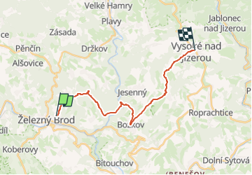
Tocht Te voet van 17,1 km beschikbaar op Noordoost, Liberecký kraj, Železný Brod. Deze tocht wordt voorgesteld door SityTrail - itinéraires balisés pédestres.
Tocht aangemaakt door cz:KČT.
![Tocht Te voet Železný Brod - [M] Železný Brod - Bozkov - Photo 1](https://media.geolcdn.com/t/2048/auto/a1cc8e9a-fb87-4723-8fc9-4e3eb78c3025.jpeg&format=jpg&maxdim=0 "Tocht Te voet Železný Brod - [M] Železný Brod - Bozkov - Photo 1")
![Tocht Te voet Železný Brod - [M] Železný Brod - Bozkov - Photo 2](https://media.geolcdn.com/t/2048/auto/6d189275-3346-4f11-853b-1e6aef5fe1fe.jpeg&format=jpg&maxdim=0 "Tocht Te voet Železný Brod - [M] Železný Brod - Bozkov - Photo 2")
![Tocht Te voet Železný Brod - [M] Železný Brod - Bozkov - Photo 3](https://media.geolcdn.com/t/2048/auto/23614619-de68-4433-b4a0-75f7d1e9039d.jpeg&format=jpg&maxdim=0 "Tocht Te voet Železný Brod - [M] Železný Brod - Bozkov - Photo 3")
![Tocht Te voet Železný Brod - [M] Železný Brod - Bozkov - Photo 4](https://media.geolcdn.com/t/2048/auto/25a00ac7-75fb-4888-8a60-eb57bafb52be.jpeg&format=jpg&maxdim=0 "Tocht Te voet Železný Brod - [M] Železný Brod - Bozkov - Photo 4")
![Tocht Te voet Železný Brod - [M] Železný Brod - Bozkov - Photo 5](https://media.geolcdn.com/t/2048/auto/56462708-cae2-46dd-af5b-4265f63e865f.jpeg&format=jpg&maxdim=0 "Tocht Te voet Železný Brod - [M] Železný Brod - Bozkov - Photo 5")
![Tocht Te voet Železný Brod - [M] Železný Brod - Bozkov - Photo 6](https://media.geolcdn.com/t/2048/auto/c2329e09-b008-4ea9-987e-347c76c144ee.jpeg&format=jpg&maxdim=0 "Tocht Te voet Železný Brod - [M] Železný Brod - Bozkov - Photo 6")
![Tocht Te voet Železný Brod - [M] Železný Brod - Bozkov - Photo 7](https://media.geolcdn.com/t/2048/auto/f3ef7404-acf7-4b3f-b885-ba5b675fed56.jpeg&format=jpg&maxdim=0 "Tocht Te voet Železný Brod - [M] Železný Brod - Bozkov - Photo 7")
![Tocht Te voet Železný Brod - [M] Železný Brod - Bozkov - Photo 8](https://media.geolcdn.com/t/2048/auto/296f2ac9-523e-48de-968a-d767d20b3704.jpeg&format=jpg&maxdim=0 "Tocht Te voet Železný Brod - [M] Železný Brod - Bozkov - Photo 8")
![Tocht Te voet Železný Brod - [M] Železný Brod - Bozkov - Photo 9](https://media.geolcdn.com/t/2048/auto/79ed1f14-58d9-4b02-843a-7329ed04a39c.jpeg&format=jpg&maxdim=0 "Tocht Te voet Železný Brod - [M] Železný Brod - Bozkov - Photo 9")
![Tocht Te voet Železný Brod - [M] Železný Brod - Bozkov - Photo 10](https://media.geolcdn.com/t/2048/auto/adb30047-d63e-4dac-9668-d1ce55b1c46f.jpeg&format=jpg&maxdim=0 "Tocht Te voet Železný Brod - [M] Železný Brod - Bozkov - Photo 10")
![Tocht Te voet Semily - [Ž] Semily - Sejkorská kaple - Bitouchov - Photo](https://media.geolcdn.com/t/375/260/ad273ffb-8712-4976-94a1-7a2514a4e8d8.jpeg&format=jpg&maxdim=2)
Te voet
![Tocht Te voet Zlatá Olešnice - [Ž] Semily - Navarov - Photo](https://media.geolcdn.com/t/375/260/5523b8f3-209a-4272-a9d5-33fce53a0bdf.jpeg&format=jpg&maxdim=2)
Te voet
![Tocht Te voet Zlatá Olešnice - [Z] Vysoké nad Jizerou - Navarov - Photo](https://media.geolcdn.com/t/375/260/bb77414f-83f5-400f-80e3-784a7ebc3b43.jpeg&format=jpg&maxdim=2)
Te voet
![Tocht Te voet Chuchelna - [Ž] Semily - U Krkavčí skály - Photo](https://media.geolcdn.com/t/375/260/a7e8cadb-e577-4017-bd0b-837334638646.jpeg&format=jpg&maxdim=2)
Te voet
![Tocht Te voet Železný Brod - [Ž] Železný Brod - Haratina - okruh - Photo](https://media.geolcdn.com/t/375/260/8202f669-ebe5-4de0-ba9e-f735bb27a1ff.jpeg&format=jpg&maxdim=2)
Te voet
![Tocht Te voet Železný Brod - [Z] Berany - Hrubá Horka - Photo](https://media.geolcdn.com/t/375/260/85b5fcbf-013c-4152-8474-e3ec21cfb00d.jpeg&format=jpg&maxdim=2)
Te voet
Te voet
Te voet
![Tocht Te voet Semily - [Z] Jilemnice - Vrchlabí - Photo](https://media.geolcdn.com/t/375/260/ext.jpg?maxdim=2&url=https%3A%2F%2Fstatic1.geolcdn.com%2Fsiteimages%2Fupload%2Ffiles%2F1545311037marcheuse_200dpi.jpg)
Te voet