


5,3 km | 5,9 km-effort
![Tocht Te voet Libovice - [Ž] Slaný - U Jána - Photo](https://media.geolcdn.com/t/1900/400/4c92c36a-58cf-41ef-9089-835f8abdcec7.jpeg&format=pjpeg&maxdim=2)

Tous les sentiers balisés d’Europe GUIDE+


Gratisgps-wandelapplicatie
 SityTrail
IGN / Geografische instituten
SityTrail World
De wereld gaat voor u open
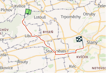
Tocht Te voet van 7,7 km beschikbaar op Centraal-Bohemen, Onbekend, Libovice. Deze tocht wordt voorgesteld door SityTrail - itinéraires balisés pédestres.
Tocht aangemaakt door cz:KČT.
![Tocht Te voet Libovice - [Ž] Slaný - U Jána - Photo 1](https://media.geolcdn.com/t/2048/auto/89776475-0bce-459f-815c-9b9b95e13004.jpeg&format=jpg&maxdim=0 "Tocht Te voet Libovice - [Ž] Slaný - U Jána - Photo 1")
![Tocht Te voet Libovice - [Ž] Slaný - U Jána - Photo 2](https://media.geolcdn.com/t/2048/auto/43656660-0979-4d82-baf7-eb9fd69caf51.jpeg&format=jpg&maxdim=0 "Tocht Te voet Libovice - [Ž] Slaný - U Jána - Photo 2")
![Tocht Te voet Libovice - [Ž] Slaný - U Jána - Photo 3](https://media.geolcdn.com/t/2048/auto/7e432810-e68c-4c9f-9c55-40a3dd8e8c11.jpeg&format=jpg&maxdim=0 "Tocht Te voet Libovice - [Ž] Slaný - U Jána - Photo 3")
![Tocht Te voet Libovice - [Ž] Slaný - U Jána - Photo 4](https://media.geolcdn.com/t/2048/auto/1cdadd68-1e97-40fd-b818-3a833d6bb939.jpeg&format=jpg&maxdim=0 "Tocht Te voet Libovice - [Ž] Slaný - U Jána - Photo 4")
![Tocht Te voet Libovice - [Ž] Slaný - U Jána - Photo 5](https://media.geolcdn.com/t/2048/auto/69eb6bd4-eee4-48a6-8fe4-535566c8f1fd.jpeg&format=jpg&maxdim=0 "Tocht Te voet Libovice - [Ž] Slaný - U Jána - Photo 5")
![Tocht Te voet Libovice - [Ž] Slaný - U Jána - Photo 6](https://media.geolcdn.com/t/2048/auto/dcd61189-7de9-4c87-84ef-0e17f69462b4.jpeg&format=jpg&maxdim=0 "Tocht Te voet Libovice - [Ž] Slaný - U Jána - Photo 6")
![Tocht Te voet Libovice - [Ž] Slaný - U Jána - Photo 7](https://media.geolcdn.com/t/2048/auto/fa327308-46d9-4c12-8db3-75410e65fe98.jpeg&format=jpg&maxdim=0 "Tocht Te voet Libovice - [Ž] Slaný - U Jána - Photo 7")
![Tocht Te voet Libovice - [Ž] Slaný - U Jána - Photo 8](https://media.geolcdn.com/t/2048/auto/7c55f3a6-b8b6-4a97-86e8-8a8e472f50e7.jpeg&format=jpg&maxdim=0 "Tocht Te voet Libovice - [Ž] Slaný - U Jána - Photo 8")
![Tocht Te voet Libovice - [Ž] Slaný - U Jána - Photo 9](https://media.geolcdn.com/t/2048/auto/9ffad348-826e-46a1-adff-0865709c0e8a.jpeg&format=jpg&maxdim=0 "Tocht Te voet Libovice - [Ž] Slaný - U Jána - Photo 9")
![Tocht Te voet Libovice - [Ž] Slaný - U Jána - Photo 10](https://media.geolcdn.com/t/2048/auto/4c92c36a-58cf-41ef-9089-835f8abdcec7.jpeg&format=jpg&maxdim=0 "Tocht Te voet Libovice - [Ž] Slaný - U Jána - Photo 10")
![Tocht Te voet Evaň - [Z] Poplze - Horka - Photo](https://media.geolcdn.com/t/375/260/58b6020a-01a4-4926-b083-ab4b33d6a3be.jpeg&format=jpg&maxdim=2)
Te voet
Te voet
Te voet
![Tocht Te voet Nové Strašecí - [Ž] Nové Strašecí - Punčocha, rybník - Photo](https://media.geolcdn.com/t/375/260/44bfaf8e-a472-4cd5-9fd6-cf12bbe0e639.jpeg&format=jpg&maxdim=2)
Te voet
Te voet
![Tocht Te voet Číčovice - [Ž] Malé Číčovice - Zákolany - Photo](https://media.geolcdn.com/t/375/260/27611625-39fc-4b9e-a6da-b31d609d094c.jpeg&format=jpg&maxdim=2)
Te voet
![Tocht Te voet Milý - [Ž] Mšec - Milý - Photo](https://media.geolcdn.com/t/375/260/dca1caca-11bd-48f5-a342-341234bf00ce.jpeg&format=jpg&maxdim=2)
Te voet
![Tocht Te voet Rakovník - [Ž] Měststský okruh IVV - Photo](https://media.geolcdn.com/t/375/260/eff4da05-f915-4356-8fee-71a257493d98.jpeg&format=jpg&maxdim=2)
Te voet
![Tocht Te voet Roudnice nad Labem - [Č] Roudnické památky - Photo](https://media.geolcdn.com/t/375/260/b68a6812-c77d-4a62-841a-9dda703f6982.jpeg&format=jpg&maxdim=2)
Te voet