


3,5 km | 5,7 km-effort
![Tocht Te voet Kněžnice - [M] Cidlina - Tábor - Photo](https://media.geolcdn.com/t/1900/400/0a816a3e-7973-444e-9da4-379e768f3f8c.jpeg&format=pjpeg&maxdim=2)

Tous les sentiers balisés d’Europe GUIDE+


Gratisgps-wandelapplicatie
 SityTrail
IGN / Geografische instituten
SityTrail World
De wereld gaat voor u open
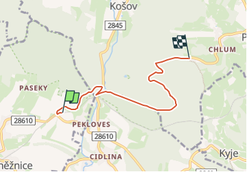
Tocht Te voet van 4,8 km beschikbaar op Noordoost, Královéhradecký kraj, Kněžnice. Deze tocht wordt voorgesteld door SityTrail - itinéraires balisés pédestres.
Tocht aangemaakt door cz:KČT.
![Tocht Te voet Kněžnice - [M] Cidlina - Tábor - Photo 1](https://media.geolcdn.com/t/2048/auto/3e4a217d-6d0f-4689-98e4-222720430e41.jpeg&format=jpg&maxdim=0 "Tocht Te voet Kněžnice - [M] Cidlina - Tábor - Photo 1")
![Tocht Te voet Kněžnice - [M] Cidlina - Tábor - Photo 2](https://media.geolcdn.com/t/2048/auto/1aeb45b2-d7ea-455d-9e0e-78f9628493c8.jpeg&format=jpg&maxdim=0 "Tocht Te voet Kněžnice - [M] Cidlina - Tábor - Photo 2")
![Tocht Te voet Kněžnice - [M] Cidlina - Tábor - Photo 3](https://media.geolcdn.com/t/2048/auto/b283eac7-7eba-4e26-8f21-eface491295d.jpeg&format=jpg&maxdim=0 "Tocht Te voet Kněžnice - [M] Cidlina - Tábor - Photo 3")
![Tocht Te voet Kněžnice - [M] Cidlina - Tábor - Photo 4](https://media.geolcdn.com/t/2048/auto/ba0a4d72-8563-4a55-9b3f-46af7ef64b25.jpeg&format=jpg&maxdim=0 "Tocht Te voet Kněžnice - [M] Cidlina - Tábor - Photo 4")
![Tocht Te voet Kněžnice - [M] Cidlina - Tábor - Photo 5](https://media.geolcdn.com/t/2048/auto/a70c0998-ab79-4e06-ada0-efe50269c13b.jpeg&format=jpg&maxdim=0 "Tocht Te voet Kněžnice - [M] Cidlina - Tábor - Photo 5")
![Tocht Te voet Kněžnice - [M] Cidlina - Tábor - Photo 6](https://media.geolcdn.com/t/2048/auto/37fdfc8b-5ece-4ca0-a6db-29c1b74d3b6c.jpeg&format=jpg&maxdim=0 "Tocht Te voet Kněžnice - [M] Cidlina - Tábor - Photo 6")
![Tocht Te voet Kněžnice - [M] Cidlina - Tábor - Photo 7](https://media.geolcdn.com/t/2048/auto/ecb056b3-745e-4e18-a524-6f91ac85cb89.jpeg&format=jpg&maxdim=0 "Tocht Te voet Kněžnice - [M] Cidlina - Tábor - Photo 7")
![Tocht Te voet Kněžnice - [M] Cidlina - Tábor - Photo 8](https://media.geolcdn.com/t/2048/auto/52abc381-6734-411d-9c6b-b372dd42823f.jpeg&format=jpg&maxdim=0 "Tocht Te voet Kněžnice - [M] Cidlina - Tábor - Photo 8")
![Tocht Te voet Kněžnice - [M] Cidlina - Tábor - Photo 9](https://media.geolcdn.com/t/2048/auto/0a816a3e-7973-444e-9da4-379e768f3f8c.jpeg&format=jpg&maxdim=0 "Tocht Te voet Kněžnice - [M] Cidlina - Tábor - Photo 9")
![Tocht Te voet Kněžnice - [M] Cidlina - Tábor - Photo 10](https://media.geolcdn.com/t/2048/auto/bc0d6c84-967c-4946-a3b6-2ffe4f24c5e7.jpeg&format=jpg&maxdim=0 "Tocht Te voet Kněžnice - [M] Cidlina - Tábor - Photo 10")
![Tocht Te voet Železnice - [Z] - Photo](https://media.geolcdn.com/t/375/260/10e44aab-2d61-4de4-bee9-7cd4d8199e14.jpeg&format=jpg&maxdim=2)
Te voet
![Tocht Te voet Železnice - [M] Klepanda - Železnice - Photo](https://media.geolcdn.com/t/375/260/832322d6-77e9-49e6-bca3-0a99f605ca60.jpeg&format=jpg&maxdim=2)
Te voet
![Tocht Te voet Lomnice nad Popelkou - [Ž] Lomnice nad Popelkou - Kyje - Photo](https://media.geolcdn.com/t/375/260/09cb1820-a01f-4e2d-a6b0-20f89a9594cb.jpeg&format=jpg&maxdim=2)
Te voet
Te voet
![Tocht Te voet Brada-Rybníček - [Z] Bradačka - Železnice - Photo](https://media.geolcdn.com/t/375/260/37505409-b0d1-440d-bf83-6e0ecd2445fd.jpeg&format=jpg&maxdim=2)
Te voet
![Tocht Te voet Lomnice nad Popelkou - [Z] Lomnice nad Popelkou - Libuň - Photo](https://media.geolcdn.com/t/375/260/0e90f3cf-52a4-48ba-b9fe-9ffc7ef48a5d.jpeg&format=jpg&maxdim=2)
Te voet
![Tocht Te voet Lomnice nad Popelkou - [Ž] Lomnice nad Popelkou - Skuhrov - Photo](https://media.geolcdn.com/t/375/260/a2049e7b-5873-4baa-88ea-15bbc073b045.jpeg&format=jpg&maxdim=2)
Te voet