![](/images/other/stat-length.png)
![Tocht Te voet Luká - CZ-NS Špraněk - Photo](https://media.geolcdn.com/t/1900/400/2830c35b-8daa-4e2e-8571-8eb1928c831f.jpeg&format=pjpeg&maxdim=2)
CZ-NS Špraněk
SityTrail - itinéraires balisés pédestres
Tous les sentiers balisés d’Europe GUIDE+
![Lengte](/images/other/stat-length.png)
Lengte
3,4 km
![Max. hoogte](https://static1.geolcdn.com/siteimages/upload/files/1508320355ic_sort_altitude_max_24dp.png)
Max. hoogte
504 m
![Positief hoogteverschil](https://static1.geolcdn.com/siteimages/upload/files/1508320355ic_sort_den_pos_24dp.png)
Positief hoogteverschil
121 m
![Km-Effort](/images/other/stat-length.png)
Km-Effort
5 km
![Min. hoogte](https://static1.geolcdn.com/siteimages/upload/files/1508320355ic_sort_altitude_min_24dp.png)
Min. hoogte
409 m
![Negatief hoogteverschil](https://static1.geolcdn.com/siteimages/upload/files/1508320355ic_sort_den_neg_24dp.png)
Negatief hoogteverschil
119 m
![Boucle](https://static1.geolcdn.com/siteimages/upload/files/16400158638029165_repeat_loop_refresh_sync_direction_icon.png)
Boucle
Ja
Markering
Datum van aanmaak :
2025-02-07 04:05:08.444
Laatste wijziging :
2025-02-07 04:05:08.444
![Te voet](https://static1.geolcdn.com/sitytour/trail-icons/100.png)
1h08
Moeilijkheid : Gemakkelijk
![Scan deze QR-code om de tocht te openen in de SityTrail-applicatie](https://capi.geolives.com/qq0zvz2zws4bq2lad0pu/sitytour/trails/4344568/qr.png?size=200)
Gratisgps-wandelapplicatie
Over ons
Tocht Te voet van 3,4 km beschikbaar op Centraal-Moravië, Olomoucký kraj, Luká. Deze tocht wordt voorgesteld door SityTrail - itinéraires balisés pédestres.
Beschrijving
Tocht aangemaakt door cz:KČT.
NS Špraněk
Plaatsbepaling
Land:
Czech Republic
Regio :
Centraal-Moravië
Departement/Provincie :
Olomoucký kraj
Gemeente :
Luká
Locatie:
Unknown
Vertrek:(Dec)
Vertrek:(UTM)
638105 ; 5503752 (33U) N.
Opmerkingen
Wandeltochten in de omgeving
![Tocht Te voet Senice na Hané - NS Elišky z Kunštátu - Photo](https://media.geolcdn.com/t/375/260/4d1449a7-b2b6-4cb4-aaeb-ec2a9aea6a88.jpeg&format=jpg&maxdim=2)
![Te voet Te voet](https://static1.geolcdn.com/sitytour/trail-icons/100.png)
NS Elišky z Kunštátu
Te voet
Gemakkelijk
Senice na Hané,
Centraal-Moravië,
Olomoucký kraj,
Czech Republic
![](/images/other/stat-length.png)
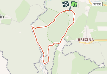
10,4 km | 12,4 km-effort
2h 48min
![](https://static1.geolcdn.com/siteimages/upload/files/16400158638029165_repeat_loop_refresh_sync_direction_icon.png)
Neen
![Tocht Te voet Velké Opatovice - NS Velké Opatovice a okolí - Photo](https://media.geolcdn.com/t/375/260/a55e7f62-0be2-4b16-9696-9bcbbb42a559.jpeg&format=jpg&maxdim=2)
![Te voet Te voet](https://static1.geolcdn.com/sitytour/trail-icons/100.png)
NS Velké Opatovice a okolí
Te voet
Gemakkelijk
Velké Opatovice,
Zuidoost,
Zuid-Moravië,
Czech Republic
![](/images/other/stat-length.png)
3,9 km | 5,3 km-effort
1h 12min
![](https://static1.geolcdn.com/siteimages/upload/files/16400158638029165_repeat_loop_refresh_sync_direction_icon.png)
Ja
![Tocht Te voet Konice - [Z] Runářov - Konice - Photo](https://media.geolcdn.com/t/375/260/90af7c62-097b-4fe0-b74f-f80499e5b5f8.jpeg&format=jpg&maxdim=2)
![Te voet Te voet](https://static1.geolcdn.com/sitytour/trail-icons/100.png)
[Z] Runářov - Konice
Te voet
Gemakkelijk
Konice,
Centraal-Moravië,
Olomoucký kraj,
Czech Republic
![](/images/other/stat-length.png)
4,3 km | 5,5 km-effort
1h 14min
![](https://static1.geolcdn.com/siteimages/upload/files/16400158638029165_repeat_loop_refresh_sync_direction_icon.png)
Neen
![Tocht Te voet Jevíčko - Muřinohova literární stezka - Photo](https://media.geolcdn.com/t/375/260/79e06201-790c-4819-8c49-34b6d1203107.jpeg&format=jpg&maxdim=2)
![Te voet Te voet](https://static1.geolcdn.com/sitytour/trail-icons/100.png)
Muřinohova literární stezka
Te voet
Gemakkelijk
Jevíčko,
Noordoost,
Pardubický kraj,
Czech Republic
![](/images/other/stat-length.png)
6 km | 7,4 km-effort
1h 40min
![](https://static1.geolcdn.com/siteimages/upload/files/16400158638029165_repeat_loop_refresh_sync_direction_icon.png)
Neen
![Tocht Te voet Litovel - NS Luhy Litovelskeho Pomoravi - Photo](https://media.geolcdn.com/t/375/260/eccbd319-b352-4f52-9d78-c29cff007dbc.jpeg&format=jpg&maxdim=2)
![Te voet Te voet](https://static1.geolcdn.com/sitytour/trail-icons/100.png)
NS Luhy Litovelskeho Pomoravi
Te voet
Gemakkelijk
Litovel,
Centraal-Moravië,
Olomoucký kraj,
Czech Republic
![](/images/other/stat-length.png)
11,2 km | 12,3 km-effort
2h 47min
![](https://static1.geolcdn.com/siteimages/upload/files/16400158638029165_repeat_loop_refresh_sync_direction_icon.png)
Neen
![Tocht Te voet Jevíčko - NS Bělásek - Photo](https://media.geolcdn.com/t/375/260/20782794-dd75-40bf-89d8-cdf3e7107a40.jpeg&format=jpg&maxdim=2)
![Te voet Te voet](https://static1.geolcdn.com/sitytour/trail-icons/100.png)
NS Bělásek
Te voet
Gemakkelijk
Jevíčko,
Noordoost,
Pardubický kraj,
Czech Republic
![](/images/other/stat-length.png)
6 km | 7,6 km-effort
1h 43min
![](https://static1.geolcdn.com/siteimages/upload/files/16400158638029165_repeat_loop_refresh_sync_direction_icon.png)
Neen
![Tocht Te voet Bílá Lhota - Naučná stezka romantický areál Nové Zámky - Photo](https://media.geolcdn.com/t/375/260/d01eff3c-f48b-45ae-a581-ad7c849ab48d.jpeg&format=jpg&maxdim=2)
![Te voet Te voet](https://static1.geolcdn.com/sitytour/trail-icons/100.png)
Naučná stezka romantický areál Nové Zámky
Te voet
Gemakkelijk
Bílá Lhota,
Centraal-Moravië,
Olomoucký kraj,
Czech Republic
![](/images/other/stat-length.png)
8,5 km | 9,8 km-effort
2h 13min
![](https://static1.geolcdn.com/siteimages/upload/files/16400158638029165_repeat_loop_refresh_sync_direction_icon.png)
Neen
![Tocht Te voet Mladeč - Naučná stezka Třesín - Photo](https://media.geolcdn.com/t/375/260/ae7c8627-022e-4eba-a7f1-d3dbcdd25dd9.jpeg&format=jpg&maxdim=2)
![Te voet Te voet](https://static1.geolcdn.com/sitytour/trail-icons/100.png)
Naučná stezka Třesín
Te voet
Gemakkelijk
Mladeč,
Centraal-Moravië,
Olomoucký kraj,
Czech Republic
![](/images/other/stat-length.png)
4,9 km | 7,1 km-effort
1h 36min
![](https://static1.geolcdn.com/siteimages/upload/files/16400158638029165_repeat_loop_refresh_sync_direction_icon.png)
Ja
![Tocht Te voet Kladky - NS Kladecko - Photo](https://media.geolcdn.com/t/375/260/c7afc8b1-8676-4c46-9898-5a8b6a489c15.jpeg&format=jpg&maxdim=2)
![Te voet Te voet](https://static1.geolcdn.com/sitytour/trail-icons/100.png)
NS Kladecko
Te voet
Gemakkelijk
Kladky,
Centraal-Moravië,
Olomoucký kraj,
Czech Republic
![](/images/other/stat-length.png)
7,1 km | 9,7 km-effort
2h 12min
![](https://static1.geolcdn.com/siteimages/upload/files/16400158638029165_repeat_loop_refresh_sync_direction_icon.png)
Neen