


5,5 km | 8,4 km-effort
![Tocht Te voet Hrob - [Z] 3933 Hrob (nám.,bus) - Vilejšov (zaniklá obec) - Photo](https://media.geolcdn.com/t/1900/400/71381ea2-8c89-4db6-b60b-4f9d6c6f09c6.jpeg&format=pjpeg&maxdim=2)

Tous les sentiers balisés d’Europe GUIDE+


Gratisgps-wandelapplicatie
 SityTrail
IGN / Geografische instituten
SityTrail World
De wereld gaat voor u open
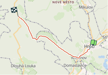
Tocht Te voet van 7,9 km beschikbaar op Noordwest, Ústecký kraj, Hrob. Deze tocht wordt voorgesteld door SityTrail - itinéraires balisés pédestres.
Tocht aangemaakt door cz:KČT.
zelená: Hrob - Vilejšov
![Tocht Te voet Hrob - [Z] 3933 Hrob (nám.,bus) - Vilejšov (zaniklá obec) - Photo 1](https://media.geolcdn.com/t/2048/auto/2b8a1f15-8285-437e-9c4b-ca681ce4b545.jpeg&format=jpg&maxdim=0 "Tocht Te voet Hrob - [Z] 3933 Hrob (nám.,bus) - Vilejšov (zaniklá obec) - Photo 1")
![Tocht Te voet Hrob - [Z] 3933 Hrob (nám.,bus) - Vilejšov (zaniklá obec) - Photo 2](https://media.geolcdn.com/t/2048/auto/469e5c0d-f0d3-422c-b662-b2ed08e723b7.jpeg&format=jpg&maxdim=0 "Tocht Te voet Hrob - [Z] 3933 Hrob (nám.,bus) - Vilejšov (zaniklá obec) - Photo 2")
![Tocht Te voet Hrob - [Z] 3933 Hrob (nám.,bus) - Vilejšov (zaniklá obec) - Photo 3](https://media.geolcdn.com/t/2048/auto/4aca95ef-5ac8-4a06-98c5-1514d9ba9368.jpeg&format=jpg&maxdim=0 "Tocht Te voet Hrob - [Z] 3933 Hrob (nám.,bus) - Vilejšov (zaniklá obec) - Photo 3")
![Tocht Te voet Hrob - [Z] 3933 Hrob (nám.,bus) - Vilejšov (zaniklá obec) - Photo 4](https://media.geolcdn.com/t/2048/auto/3198aa3c-3d78-4185-92fe-e92c81101f64.jpeg&format=jpg&maxdim=0 "Tocht Te voet Hrob - [Z] 3933 Hrob (nám.,bus) - Vilejšov (zaniklá obec) - Photo 4")
![Tocht Te voet Hrob - [Z] 3933 Hrob (nám.,bus) - Vilejšov (zaniklá obec) - Photo 5](https://media.geolcdn.com/t/2048/auto/9cde89b1-43c1-4241-9ac3-f77a8f152dd5.jpeg&format=jpg&maxdim=0 "Tocht Te voet Hrob - [Z] 3933 Hrob (nám.,bus) - Vilejšov (zaniklá obec) - Photo 5")
![Tocht Te voet Hrob - [Z] 3933 Hrob (nám.,bus) - Vilejšov (zaniklá obec) - Photo 6](https://media.geolcdn.com/t/2048/auto/4e9cc4b6-fe1c-40b2-9d01-2a1e632f4d33.jpeg&format=jpg&maxdim=0 "Tocht Te voet Hrob - [Z] 3933 Hrob (nám.,bus) - Vilejšov (zaniklá obec) - Photo 6")
![Tocht Te voet Hrob - [Z] 3933 Hrob (nám.,bus) - Vilejšov (zaniklá obec) - Photo 7](https://media.geolcdn.com/t/2048/auto/e0339b4d-66c7-4f3b-bafb-4a7ab732cbff.jpeg&format=jpg&maxdim=0 "Tocht Te voet Hrob - [Z] 3933 Hrob (nám.,bus) - Vilejšov (zaniklá obec) - Photo 7")
![Tocht Te voet Hrob - [Z] 3933 Hrob (nám.,bus) - Vilejšov (zaniklá obec) - Photo 8](https://media.geolcdn.com/t/2048/auto/21c24564-2811-4a0e-8b48-c9777296f565.jpeg&format=jpg&maxdim=0 "Tocht Te voet Hrob - [Z] 3933 Hrob (nám.,bus) - Vilejšov (zaniklá obec) - Photo 8")
![Tocht Te voet Hrob - [Z] 3933 Hrob (nám.,bus) - Vilejšov (zaniklá obec) - Photo 9](https://media.geolcdn.com/t/2048/auto/9ad77ed0-2cde-434b-bc9f-352a8580979e.jpeg&format=jpg&maxdim=0 "Tocht Te voet Hrob - [Z] 3933 Hrob (nám.,bus) - Vilejšov (zaniklá obec) - Photo 9")
![Tocht Te voet Hrob - [Z] 3933 Hrob (nám.,bus) - Vilejšov (zaniklá obec) - Photo 10](https://media.geolcdn.com/t/2048/auto/71381ea2-8c89-4db6-b60b-4f9d6c6f09c6.jpeg&format=jpg&maxdim=0 "Tocht Te voet Hrob - [Z] 3933 Hrob (nám.,bus) - Vilejšov (zaniklá obec) - Photo 10")
![Tocht Te voet Dubí - [M] Okruh kolem Francouzského kamene - Photo](https://media.geolcdn.com/t/375/260/394e4c19-d604-4c61-b996-a104413a844a.jpeg&format=jpg&maxdim=2)
Te voet
![Tocht Te voet Dubí - [černá] Dubský Mikulovský okruh - Photo](https://media.geolcdn.com/t/375/260/51f015ee-3102-4ce3-8fc3-e9598c9230ee.jpeg&format=jpg&maxdim=2)
Te voet
![Tocht Te voet Duchcov - [Ž] Liptická stezka - Photo](https://media.geolcdn.com/t/375/260/3892228e-d555-4ad4-b46a-4b4f2dfb6e4d.jpeg&format=jpg&maxdim=2)
Te voet
![Tocht Te voet Dubí - [O] Dubský západní okruh - Photo](https://media.geolcdn.com/t/375/260/4053a66a-61a3-4728-9c78-0f564a854477.jpeg&format=jpg&maxdim=2)
Te voet
![Tocht Te voet Dubí - [Č] Dubský dolní lázeňský okruh - Photo](https://media.geolcdn.com/t/375/260/578f8f1d-780c-426d-828d-7daead75abe9.jpeg&format=jpg&maxdim=2)
Te voet
![Tocht Te voet Dubí - [M] Dubský východní okruh - Photo](https://media.geolcdn.com/t/375/260/ea1a17e4-fa35-46cf-a917-1369a19b3e74.jpeg&format=jpg&maxdim=2)
Te voet
![Tocht Te voet Hrob - [Ž] 6928 Hrob nám. - Loučná bus - Photo](https://media.geolcdn.com/t/375/260/fcba0402-741d-4b23-9e6c-e1aafb179882.jpeg&format=jpg&maxdim=2)
Te voet