


8,6 km | 11,3 km-effort
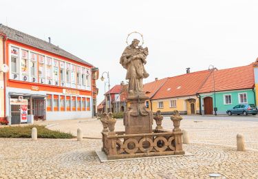
![Tocht Te voet Bošice - [M] Hradčany - Lčovice - Photo](https://media.geolcdn.com/t/1900/400/acafe685-58d6-47a5-b6df-5eebf9f111a1.jpeg&format=pjpeg&maxdim=2)

Tous les sentiers balisés d’Europe GUIDE+


Gratisgps-wandelapplicatie
 SityTrail
IGN / Geografische instituten
SityTrail World
De wereld gaat voor u open
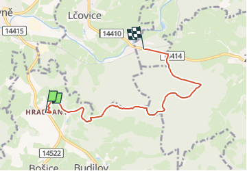
Tocht Te voet van 5,6 km beschikbaar op Zuidwest, Zuid-Bohemen, Bošice. Deze tocht wordt voorgesteld door SityTrail - itinéraires balisés pédestres.
Tocht aangemaakt door cz:KČT.
![Tocht Te voet Bošice - [M] Hradčany - Lčovice - Photo 1](https://media.geolcdn.com/t/2048/auto/e107ab2c-c952-4851-b9cb-474f6fcbd4dc.jpeg&format=jpg&maxdim=0 "Tocht Te voet Bošice - [M] Hradčany - Lčovice - Photo 1")
![Tocht Te voet Bošice - [M] Hradčany - Lčovice - Photo 2](https://media.geolcdn.com/t/2048/auto/e2b2e5d8-ad5b-41ae-b8d3-cb1db708cf5a.jpeg&format=jpg&maxdim=0 "Tocht Te voet Bošice - [M] Hradčany - Lčovice - Photo 2")
![Tocht Te voet Bošice - [M] Hradčany - Lčovice - Photo 3](https://media.geolcdn.com/t/2048/auto/57c1401b-6f81-4476-b741-29a44ee2cda6.jpeg&format=jpg&maxdim=0 "Tocht Te voet Bošice - [M] Hradčany - Lčovice - Photo 3")
![Tocht Te voet Bošice - [M] Hradčany - Lčovice - Photo 4](https://media.geolcdn.com/t/2048/auto/a6f58ce9-07e0-48dd-99cd-4bac7e584de4.jpeg&format=jpg&maxdim=0 "Tocht Te voet Bošice - [M] Hradčany - Lčovice - Photo 4")
![Tocht Te voet Bošice - [M] Hradčany - Lčovice - Photo 5](https://media.geolcdn.com/t/2048/auto/891fbd6e-3109-487a-bb1e-54eb59b74ae5.jpeg&format=jpg&maxdim=0 "Tocht Te voet Bošice - [M] Hradčany - Lčovice - Photo 5")
![Tocht Te voet Bošice - [M] Hradčany - Lčovice - Photo 6](https://media.geolcdn.com/t/2048/auto/f3189086-93ca-42f5-958f-6848993c7289.jpeg&format=jpg&maxdim=0 "Tocht Te voet Bošice - [M] Hradčany - Lčovice - Photo 6")
![Tocht Te voet Bošice - [M] Hradčany - Lčovice - Photo 7](https://media.geolcdn.com/t/2048/auto/930c8253-4837-4582-ad31-6ba58ef82b99.jpeg&format=jpg&maxdim=0 "Tocht Te voet Bošice - [M] Hradčany - Lčovice - Photo 7")
![Tocht Te voet Bošice - [M] Hradčany - Lčovice - Photo 8](https://media.geolcdn.com/t/2048/auto/faf7402a-dd3d-40a5-8bbe-5ca78f46c90a.jpeg&format=jpg&maxdim=0 "Tocht Te voet Bošice - [M] Hradčany - Lčovice - Photo 8")
![Tocht Te voet Bošice - [M] Hradčany - Lčovice - Photo 9](https://media.geolcdn.com/t/2048/auto/6b877b24-0f7b-4ad2-a3d8-4ef84ab20737.jpeg&format=jpg&maxdim=0 "Tocht Te voet Bošice - [M] Hradčany - Lčovice - Photo 9")
![Tocht Te voet Bošice - [M] Hradčany - Lčovice - Photo 10](https://media.geolcdn.com/t/2048/auto/acafe685-58d6-47a5-b6df-5eebf9f111a1.jpeg&format=jpg&maxdim=0 "Tocht Te voet Bošice - [M] Hradčany - Lčovice - Photo 10")
Te voet