


3,2 km | 5,2 km-effort
![Tocht Te voet Hodkovice nad Mohelkou - [Ž] Hodkovice nad Mohelkou - Vrchovina - Photo](https://media.geolcdn.com/t/1900/400/c8a4d6e6-c436-4c58-854e-1aa3f07f7648.jpeg&format=pjpeg&maxdim=2)

Tous les sentiers balisés d’Europe GUIDE+


Gratisgps-wandelapplicatie
 SityTrail
IGN / Geografische instituten
SityTrail World
De wereld gaat voor u open
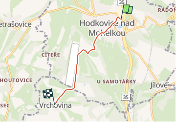
Tocht Te voet van 3,3 km beschikbaar op Noordoost, Liberecký kraj, Hodkovice nad Mohelkou. Deze tocht wordt voorgesteld door SityTrail - itinéraires balisés pédestres.
Tocht aangemaakt door cz:KČT.
yellow bar
![Tocht Te voet Hodkovice nad Mohelkou - [Ž] Hodkovice nad Mohelkou - Vrchovina - Photo 1](https://media.geolcdn.com/t/2048/auto/f011e46e-1bb3-4599-9165-5343141dd934.jpeg&format=jpg&maxdim=0 "Tocht Te voet Hodkovice nad Mohelkou - [Ž] Hodkovice nad Mohelkou - Vrchovina - Photo 1")
![Tocht Te voet Hodkovice nad Mohelkou - [Ž] Hodkovice nad Mohelkou - Vrchovina - Photo 2](https://media.geolcdn.com/t/2048/auto/22066eb6-09f7-4d18-812f-fb13ac25e89d.jpeg&format=jpg&maxdim=0 "Tocht Te voet Hodkovice nad Mohelkou - [Ž] Hodkovice nad Mohelkou - Vrchovina - Photo 2")
![Tocht Te voet Hodkovice nad Mohelkou - [Ž] Hodkovice nad Mohelkou - Vrchovina - Photo 3](https://media.geolcdn.com/t/2048/auto/827c0948-55fe-46ea-9eeb-33d53fea1298.jpeg&format=jpg&maxdim=0 "Tocht Te voet Hodkovice nad Mohelkou - [Ž] Hodkovice nad Mohelkou - Vrchovina - Photo 3")
![Tocht Te voet Hodkovice nad Mohelkou - [Ž] Hodkovice nad Mohelkou - Vrchovina - Photo 4](https://media.geolcdn.com/t/2048/auto/b247c2c4-99ce-4414-abf6-990a4f36cf7d.jpeg&format=jpg&maxdim=0 "Tocht Te voet Hodkovice nad Mohelkou - [Ž] Hodkovice nad Mohelkou - Vrchovina - Photo 4")
![Tocht Te voet Hodkovice nad Mohelkou - [Ž] Hodkovice nad Mohelkou - Vrchovina - Photo 5](https://media.geolcdn.com/t/2048/auto/dc68066d-423d-47a4-aaa2-368a783cd1d7.jpeg&format=jpg&maxdim=0 "Tocht Te voet Hodkovice nad Mohelkou - [Ž] Hodkovice nad Mohelkou - Vrchovina - Photo 5")
![Tocht Te voet Hodkovice nad Mohelkou - [Ž] Hodkovice nad Mohelkou - Vrchovina - Photo 6](https://media.geolcdn.com/t/2048/auto/06e3b5f9-e067-4e54-a083-88ed3431ca47.jpeg&format=jpg&maxdim=0 "Tocht Te voet Hodkovice nad Mohelkou - [Ž] Hodkovice nad Mohelkou - Vrchovina - Photo 6")
![Tocht Te voet Hodkovice nad Mohelkou - [Ž] Hodkovice nad Mohelkou - Vrchovina - Photo 7](https://media.geolcdn.com/t/2048/auto/57d5e3e0-8e09-4f14-91ab-bb148ea16631.jpeg&format=jpg&maxdim=0 "Tocht Te voet Hodkovice nad Mohelkou - [Ž] Hodkovice nad Mohelkou - Vrchovina - Photo 7")
![Tocht Te voet Hodkovice nad Mohelkou - [Ž] Hodkovice nad Mohelkou - Vrchovina - Photo 8](https://media.geolcdn.com/t/2048/auto/56c97f57-976a-4bb7-95e5-fe272d5f5afe.jpeg&format=jpg&maxdim=0 "Tocht Te voet Hodkovice nad Mohelkou - [Ž] Hodkovice nad Mohelkou - Vrchovina - Photo 8")
![Tocht Te voet Hodkovice nad Mohelkou - [Ž] Hodkovice nad Mohelkou - Vrchovina - Photo 9](https://media.geolcdn.com/t/2048/auto/e9fe3949-bb83-4252-a6e8-3d81ca72ed5c.jpeg&format=jpg&maxdim=0 "Tocht Te voet Hodkovice nad Mohelkou - [Ž] Hodkovice nad Mohelkou - Vrchovina - Photo 9")
![Tocht Te voet Hodkovice nad Mohelkou - [Ž] Hodkovice nad Mohelkou - Vrchovina - Photo 10](https://media.geolcdn.com/t/2048/auto/c8a4d6e6-c436-4c58-854e-1aa3f07f7648.jpeg&format=jpg&maxdim=0 "Tocht Te voet Hodkovice nad Mohelkou - [Ž] Hodkovice nad Mohelkou - Vrchovina - Photo 10")
![Tocht Te voet Rychnov u Jablonce nad Nisou - [Ž] Rychnov u Jablonce n. N. - Dobrá Voda - Photo](https://media.geolcdn.com/t/375/260/6d19918f-d3e9-4534-a7af-5e0a5166a0c2.jpeg&format=jpg&maxdim=2)
Te voet
![Tocht Te voet Dlouhý Most - [Z] Rašovské sedlo;Kohoutivice - Photo](https://media.geolcdn.com/t/375/260/7ed4b2bc-fca7-447f-aff9-a1e465f66f36.jpeg&format=jpg&maxdim=2)
Te voet
![Tocht Te voet Pulečný - [Z] Jablonec n. N. - Pulečný - Photo](https://media.geolcdn.com/t/375/260/b17bcafe-ad71-4f5a-9387-b5078f702632.jpeg&format=jpg&maxdim=2)
Te voet
Te voet
Te voet