![](/images/other/stat-length.png)
![Tocht Te voet Krásná Lípa - Köglerova naučná stezka - Photo](https://media.geolcdn.com/t/1900/400/0bae7923-6232-4122-8360-5a548ccef1f1.jpeg&format=pjpeg&maxdim=2)
Köglerova naučná stezka
SityTrail - itinéraires balisés pédestres
Tous les sentiers balisés d’Europe GUIDE+
![Lengte](/images/other/stat-length.png)
Lengte
22 km
![Max. hoogte](https://static1.geolcdn.com/siteimages/upload/files/1508320355ic_sort_altitude_max_24dp.png)
Max. hoogte
582 m
![Positief hoogteverschil](https://static1.geolcdn.com/siteimages/upload/files/1508320355ic_sort_den_pos_24dp.png)
Positief hoogteverschil
633 m
![Km-Effort](/images/other/stat-length.png)
Km-Effort
31 km
![Min. hoogte](https://static1.geolcdn.com/siteimages/upload/files/1508320355ic_sort_altitude_min_24dp.png)
Min. hoogte
362 m
![Negatief hoogteverschil](https://static1.geolcdn.com/siteimages/upload/files/1508320355ic_sort_den_neg_24dp.png)
Negatief hoogteverschil
630 m
![Boucle](https://static1.geolcdn.com/siteimages/upload/files/16400158638029165_repeat_loop_refresh_sync_direction_icon.png)
Boucle
Ja
Markering
Datum van aanmaak :
2025-02-06 23:19:08.924
Laatste wijziging :
2025-02-06 23:19:08.924
![Te voet](https://static1.geolcdn.com/sitytour/trail-icons/100.png)
6h56
Moeilijkheid : Medium
![Scan deze QR-code om de tocht te openen in de SityTrail-applicatie](https://capi.geolives.com/qq0zvz2zws4bq2lad0pu/sitytour/trails/4344250/qr.png?size=200)
Gratisgps-wandelapplicatie
Over ons
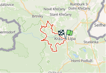
Tocht Te voet van 22 km beschikbaar op Noordwest, Ústecký kraj, Krásná Lípa. Deze tocht wordt voorgesteld door SityTrail - itinéraires balisés pédestres.
Beschrijving
Tocht aangemaakt door cz:KČT.
Plaatsbepaling
Land:
Czech Republic
Regio :
Noordwest
Departement/Provincie :
Ústecký kraj
Gemeente :
Krásná Lípa
Locatie:
Unknown
Vertrek:(Dec)
Vertrek:(UTM)
465379 ; 5640323 (33U) N.
Opmerkingen
Wandeltochten in de omgeving
![Tocht Te voet Sebnitz - Rundweg Gelber Punkt - Photo](https://media.geolcdn.com/t/375/260/de03e73a-1e26-4a74-bd13-e46beb5905b6.jpeg&format=jpg&maxdim=2)
![Te voet Te voet](https://static1.geolcdn.com/sitytour/trail-icons/100.png)
Rundweg Gelber Punkt
Te voet
Gemakkelijk
Sebnitz,
Saksen,
Sächsische Schweiz-Osterzgebirge,
Germany
![](/images/other/stat-length.png)
4,2 km | 6,3 km-effort
1h 25min
![](https://static1.geolcdn.com/siteimages/upload/files/16400158638029165_repeat_loop_refresh_sync_direction_icon.png)
Ja
![Tocht Te voet Jablonné v Podještědí - NS Putování skřítka Javorníčka za Hochwaldským mužíčkem - Photo](https://media.geolcdn.com/t/375/260/2bd62ac0-c5b4-4e2a-8083-531b799d881c.jpeg&format=jpg&maxdim=2)
![Te voet Te voet](https://static1.geolcdn.com/sitytour/trail-icons/100.png)
NS Putování skřítka Javorníčka za Hochwaldským mužíčkem
Te voet
Gemakkelijk
Jablonné v Podještědí,
Noordoost,
Liberecký kraj,
Czech Republic
![](/images/other/stat-length.png)
5 km | 6 km-effort
1h 21min
![](https://static1.geolcdn.com/siteimages/upload/files/16400158638029165_repeat_loop_refresh_sync_direction_icon.png)
Neen
![Tocht Te voet Benešov nad Ploučnicí - [Ž] Benešov nad Ploučnicí - Huntířov - Photo](https://media.geolcdn.com/t/375/260/bbcc4ada-53a6-4f1a-8a2a-532b77b1123c.jpeg&format=jpg&maxdim=2)
![Te voet Te voet](https://static1.geolcdn.com/sitytour/trail-icons/100.png)
[Ž] Benešov nad Ploučnicí - Huntířov
Te voet
Gemakkelijk
Benešov nad Ploučnicí,
Noordwest,
Ústecký kraj,
Czech Republic
![](/images/other/stat-length.png)
7,3 km | 11,2 km-effort
2h 33min
![](https://static1.geolcdn.com/siteimages/upload/files/16400158638029165_repeat_loop_refresh_sync_direction_icon.png)
Neen
![Tocht Te voet Oybin - Hartau-Forsthaus Lückendorf - Photo](https://media.geolcdn.com/t/375/260/967585d3-12d0-4868-97ea-3911345dfbb9.jpeg&format=jpg&maxdim=2)
![Te voet Te voet](https://static1.geolcdn.com/sitytour/trail-icons/100.png)
Hartau-Forsthaus Lückendorf
Te voet
Gemakkelijk
Oybin,
Saksen,
Görlitz,
Germany
![](/images/other/stat-length.png)
7,3 km | 8,4 km-effort
1h 53min
![](https://static1.geolcdn.com/siteimages/upload/files/16400158638029165_repeat_loop_refresh_sync_direction_icon.png)
Neen
![Tocht Te voet Růžová - NS Růžová - Photo](https://media.geolcdn.com/t/375/260/bc6ba9c8-0a17-4add-a538-399085b7e597.jpeg&format=jpg&maxdim=2)
![Te voet Te voet](https://static1.geolcdn.com/sitytour/trail-icons/100.png)
NS Růžová
Te voet
Gemakkelijk
Růžová,
Noordwest,
Ústecký kraj,
Czech Republic
![](/images/other/stat-length.png)
10,5 km | 14,3 km-effort
3h 15min
![](https://static1.geolcdn.com/siteimages/upload/files/16400158638029165_repeat_loop_refresh_sync_direction_icon.png)
Ja
![Tocht Te voet Hřensko - NS Okolím Hřenska - Photo](https://media.geolcdn.com/t/375/260/c6fe0c60-b9e0-421f-8c2f-b3a242ef59d4.jpeg&format=jpg&maxdim=2)
![Te voet Te voet](https://static1.geolcdn.com/sitytour/trail-icons/100.png)
NS Okolím Hřenska
Te voet
Medium
Hřensko,
Noordwest,
Ústecký kraj,
Czech Republic
![](/images/other/stat-length.png)
14,3 km | 22 km-effort
4h 54min
![](https://static1.geolcdn.com/siteimages/upload/files/16400158638029165_repeat_loop_refresh_sync_direction_icon.png)
Ja
![Tocht Te voet Sebnitz - Hinterhermsdorfer Rundweg - Photo](https://media.geolcdn.com/t/375/260/1a8e8230-aa16-4757-be71-8e0ebbd9d9d6.jpeg&format=jpg&maxdim=2)
![Te voet Te voet](https://static1.geolcdn.com/sitytour/trail-icons/100.png)
Hinterhermsdorfer Rundweg
Te voet
Gemakkelijk
Sebnitz,
Saksen,
Sächsische Schweiz-Osterzgebirge,
Germany
![](/images/other/stat-length.png)
10,6 km | 14,3 km-effort
3h 14min
![](https://static1.geolcdn.com/siteimages/upload/files/16400158638029165_repeat_loop_refresh_sync_direction_icon.png)
Ja
![Tocht Te voet Seifhennersdorf - LG-Gelber Strich - Zittau-Seifhennersdorf - Photo](https://media.geolcdn.com/t/375/260/16589c7c-c152-433d-909d-1eca6ed681c2.jpeg&format=jpg&maxdim=2)
![Te voet Te voet](https://static1.geolcdn.com/sitytour/trail-icons/100.png)
LG-Gelber Strich - Zittau-Seifhennersdorf
Te voet
Gemakkelijk
Seifhennersdorf,
Saksen,
Görlitz,
Germany
![](/images/other/stat-length.png)
8,9 km | 11,6 km-effort
2h 38min
![](https://static1.geolcdn.com/siteimages/upload/files/16400158638029165_repeat_loop_refresh_sync_direction_icon.png)
Neen
![Tocht Te voet Oybin - LG-Gelber Punkt - Photo](https://media.geolcdn.com/t/375/260/e020b87b-e555-479a-b5b4-0b494c08279a.jpeg&format=jpg&maxdim=2)
![Te voet Te voet](https://static1.geolcdn.com/sitytour/trail-icons/100.png)
LG-Gelber Punkt
Te voet
Gemakkelijk
Oybin,
Saksen,
Görlitz,
Germany
![](/images/other/stat-length.png)
4,7 km | 6,1 km-effort
1h 23min
![](https://static1.geolcdn.com/siteimages/upload/files/16400158638029165_repeat_loop_refresh_sync_direction_icon.png)
Ja