


8,9 km | 9,8 km-effort
![Tocht Te voet Litoměřice - [Ž] Litoměřice - Žalhostice - Photo](https://media.geolcdn.com/t/1900/400/8bc79a50-05ba-402a-b3dd-c0eb686c9585.jpeg&format=pjpeg&maxdim=2)

Tous les sentiers balisés d’Europe GUIDE+


Gratisgps-wandelapplicatie
 SityTrail
IGN / Geografische instituten
SityTrail World
De wereld gaat voor u open
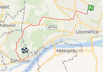
Tocht Te voet van 5,4 km beschikbaar op Noordwest, Ústecký kraj, Litoměřice. Deze tocht wordt voorgesteld door SityTrail - itinéraires balisés pédestres.
Tocht aangemaakt door cz:KČT.
![Tocht Te voet Litoměřice - [Ž] Litoměřice - Žalhostice - Photo 1](https://media.geolcdn.com/t/2048/auto/dd6696ba-bce1-4747-a8f9-8df1ada04407.jpeg&format=jpg&maxdim=0 "Tocht Te voet Litoměřice - [Ž] Litoměřice - Žalhostice - Photo 1")
![Tocht Te voet Litoměřice - [Ž] Litoměřice - Žalhostice - Photo 2](https://media.geolcdn.com/t/2048/auto/76f148c2-5979-4cd8-a2e6-0623ac01c8ff.jpeg&format=jpg&maxdim=0 "Tocht Te voet Litoměřice - [Ž] Litoměřice - Žalhostice - Photo 2")
![Tocht Te voet Litoměřice - [Ž] Litoměřice - Žalhostice - Photo 3](https://media.geolcdn.com/t/2048/auto/a4ed675b-a741-4b6f-a361-2e745a0b14db.jpeg&format=jpg&maxdim=0 "Tocht Te voet Litoměřice - [Ž] Litoměřice - Žalhostice - Photo 3")
![Tocht Te voet Litoměřice - [Ž] Litoměřice - Žalhostice - Photo 4](https://media.geolcdn.com/t/2048/auto/efc1ab41-b54f-4156-a8dc-995596729ccf.jpeg&format=jpg&maxdim=0 "Tocht Te voet Litoměřice - [Ž] Litoměřice - Žalhostice - Photo 4")
![Tocht Te voet Litoměřice - [Ž] Litoměřice - Žalhostice - Photo 5](https://media.geolcdn.com/t/2048/auto/8217b71b-616a-4b80-adcf-bdca744d673f.jpeg&format=jpg&maxdim=0 "Tocht Te voet Litoměřice - [Ž] Litoměřice - Žalhostice - Photo 5")
![Tocht Te voet Litoměřice - [Ž] Litoměřice - Žalhostice - Photo 6](https://media.geolcdn.com/t/2048/auto/d4ae88c9-29ab-433f-8156-7be3a5fadac8.jpeg&format=jpg&maxdim=0 "Tocht Te voet Litoměřice - [Ž] Litoměřice - Žalhostice - Photo 6")
![Tocht Te voet Litoměřice - [Ž] Litoměřice - Žalhostice - Photo 7](https://media.geolcdn.com/t/2048/auto/e5e378c4-7410-4800-9ecd-8c68c4d029b4.jpeg&format=jpg&maxdim=0 "Tocht Te voet Litoměřice - [Ž] Litoměřice - Žalhostice - Photo 7")
![Tocht Te voet Litoměřice - [Ž] Litoměřice - Žalhostice - Photo 8](https://media.geolcdn.com/t/2048/auto/70cece07-423b-4b24-abe0-fbc7bdfc515b.jpeg&format=jpg&maxdim=0 "Tocht Te voet Litoměřice - [Ž] Litoměřice - Žalhostice - Photo 8")
![Tocht Te voet Litoměřice - [Ž] Litoměřice - Žalhostice - Photo 9](https://media.geolcdn.com/t/2048/auto/da837c66-8b7d-4633-95f8-a557ea223bd0.jpeg&format=jpg&maxdim=0 "Tocht Te voet Litoměřice - [Ž] Litoměřice - Žalhostice - Photo 9")
![Tocht Te voet Litoměřice - [Ž] Litoměřice - Žalhostice - Photo 10](https://media.geolcdn.com/t/2048/auto/8bc79a50-05ba-402a-b3dd-c0eb686c9585.jpeg&format=jpg&maxdim=0 "Tocht Te voet Litoměřice - [Ž] Litoměřice - Žalhostice - Photo 10")
![Tocht Te voet Litoměřice - [Z] Sebuzín - Litoměřice - Photo](https://media.geolcdn.com/t/375/260/d13b5b00-8ae2-4a20-b537-a715ffb460bd.jpeg&format=jpg&maxdim=2)
Te voet