


5,1 km | 7,1 km-effort
![Tocht Te voet Nebílovy - [Z] Štěnovice - Nebílovy - Photo](https://media.geolcdn.com/t/1900/400/78153f03-0394-41af-a8cb-63376f17de15.jpeg&format=pjpeg&maxdim=2)

Tous les sentiers balisés d’Europe GUIDE+


Gratisgps-wandelapplicatie
 SityTrail
IGN / Geografische instituten
SityTrail World
De wereld gaat voor u open
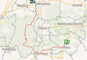
Tocht Te voet van 10,3 km beschikbaar op Zuidwest, Regio Pilsen, Nebílovy. Deze tocht wordt voorgesteld door SityTrail - itinéraires balisés pédestres.
Tocht aangemaakt door cz:KČT.
![Tocht Te voet Nebílovy - [Z] Štěnovice - Nebílovy - Photo 1](https://media.geolcdn.com/t/2048/auto/b2f308c1-eb11-4c48-b999-76bdf38e75b4.jpeg&format=jpg&maxdim=0 "Tocht Te voet Nebílovy - [Z] Štěnovice - Nebílovy - Photo 1")
![Tocht Te voet Nebílovy - [Z] Štěnovice - Nebílovy - Photo 2](https://media.geolcdn.com/t/2048/auto/5ab9c453-99af-48b6-84c4-85739c48be6b.jpeg&format=jpg&maxdim=0 "Tocht Te voet Nebílovy - [Z] Štěnovice - Nebílovy - Photo 2")
![Tocht Te voet Nebílovy - [Z] Štěnovice - Nebílovy - Photo 3](https://media.geolcdn.com/t/2048/auto/a4d47dc5-a7ea-435f-8b6b-e39b9cf32996.jpeg&format=jpg&maxdim=0 "Tocht Te voet Nebílovy - [Z] Štěnovice - Nebílovy - Photo 3")
![Tocht Te voet Nebílovy - [Z] Štěnovice - Nebílovy - Photo 4](https://media.geolcdn.com/t/2048/auto/31dda4c5-e7b3-4fd1-86dd-f18a61df62d3.jpeg&format=jpg&maxdim=0 "Tocht Te voet Nebílovy - [Z] Štěnovice - Nebílovy - Photo 4")
![Tocht Te voet Nebílovy - [Z] Štěnovice - Nebílovy - Photo 5](https://media.geolcdn.com/t/2048/auto/d32d5a99-b5ed-4d74-93b8-58ae8865356b.jpeg&format=jpg&maxdim=0 "Tocht Te voet Nebílovy - [Z] Štěnovice - Nebílovy - Photo 5")
![Tocht Te voet Nebílovy - [Z] Štěnovice - Nebílovy - Photo 6](https://media.geolcdn.com/t/2048/auto/ea1494f7-4240-44c2-bc53-7a30cc19923d.jpeg&format=jpg&maxdim=0 "Tocht Te voet Nebílovy - [Z] Štěnovice - Nebílovy - Photo 6")
![Tocht Te voet Nebílovy - [Z] Štěnovice - Nebílovy - Photo 7](https://media.geolcdn.com/t/2048/auto/7ff01482-ba15-46bc-bec5-cd942ae37c23.jpeg&format=jpg&maxdim=0 "Tocht Te voet Nebílovy - [Z] Štěnovice - Nebílovy - Photo 7")
![Tocht Te voet Nebílovy - [Z] Štěnovice - Nebílovy - Photo 8](https://media.geolcdn.com/t/2048/auto/da0263b8-fec0-465b-a99b-dab043080744.jpeg&format=jpg&maxdim=0 "Tocht Te voet Nebílovy - [Z] Štěnovice - Nebílovy - Photo 8")
![Tocht Te voet Nebílovy - [Z] Štěnovice - Nebílovy - Photo 9](https://media.geolcdn.com/t/2048/auto/78153f03-0394-41af-a8cb-63376f17de15.jpeg&format=jpg&maxdim=0 "Tocht Te voet Nebílovy - [Z] Štěnovice - Nebílovy - Photo 9")
![Tocht Te voet Nebílovy - [Z] Štěnovice - Nebílovy - Photo 10](https://media.geolcdn.com/t/2048/auto/de4d1170-bb56-4617-919c-da8e2b015a4c.jpeg&format=jpg&maxdim=0 "Tocht Te voet Nebílovy - [Z] Štěnovice - Nebílovy - Photo 10")
Te voet