


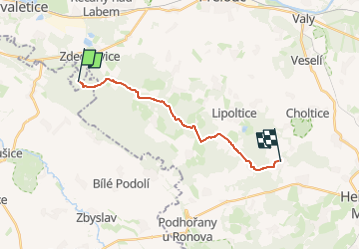

11,3 km | 13,3 km-effort
![Tocht Te voet Zdechovice - [Ž] Morašice - Svojšice - Photo](https://media.geolcdn.com/t/1900/400/f143d729-598a-40d2-b273-3cfaab803058.jpeg&format=pjpeg&maxdim=2)

Tous les sentiers balisés d’Europe GUIDE+


Gratisgps-wandelapplicatie
 SityTrail
IGN / Geografische instituten
SityTrail World
De wereld gaat voor u open
Tocht Te voet van 13,3 km beschikbaar op Noordoost, Pardubický kraj, Zdechovice. Deze tocht wordt voorgesteld door SityTrail - itinéraires balisés pédestres.
Tocht aangemaakt door cz:KČT.
![Tocht Te voet Zdechovice - [Ž] Morašice - Svojšice - Photo 1](https://media.geolcdn.com/t/2048/auto/d239a497-35cd-4b2c-8d3d-489f3c34b697.jpeg&format=jpg&maxdim=0 "Tocht Te voet Zdechovice - [Ž] Morašice - Svojšice - Photo 1")
![Tocht Te voet Zdechovice - [Ž] Morašice - Svojšice - Photo 2](https://media.geolcdn.com/t/2048/auto/a375287d-99c0-402d-a95d-88505648925b.jpeg&format=jpg&maxdim=0 "Tocht Te voet Zdechovice - [Ž] Morašice - Svojšice - Photo 2")
![Tocht Te voet Zdechovice - [Ž] Morašice - Svojšice - Photo 3](https://media.geolcdn.com/t/2048/auto/b1baf91f-ffee-4412-8fbd-34185050b497.jpeg&format=jpg&maxdim=0 "Tocht Te voet Zdechovice - [Ž] Morašice - Svojšice - Photo 3")
![Tocht Te voet Zdechovice - [Ž] Morašice - Svojšice - Photo 4](https://media.geolcdn.com/t/2048/auto/0711fcc0-56cc-4962-8007-d4aacce087b4.jpeg&format=jpg&maxdim=0 "Tocht Te voet Zdechovice - [Ž] Morašice - Svojšice - Photo 4")
![Tocht Te voet Zdechovice - [Ž] Morašice - Svojšice - Photo 5](https://media.geolcdn.com/t/2048/auto/af1b658d-ffaf-49bd-a4a4-84ef3878c94c.jpeg&format=jpg&maxdim=0 "Tocht Te voet Zdechovice - [Ž] Morašice - Svojšice - Photo 5")
![Tocht Te voet Zdechovice - [Ž] Morašice - Svojšice - Photo 6](https://media.geolcdn.com/t/2048/auto/983639a3-3e9e-4357-b341-37780d7f48da.jpeg&format=jpg&maxdim=0 "Tocht Te voet Zdechovice - [Ž] Morašice - Svojšice - Photo 6")
![Tocht Te voet Zdechovice - [Ž] Morašice - Svojšice - Photo 7](https://media.geolcdn.com/t/2048/auto/1dd38636-bced-42b9-ae48-9ae1aecc63dc.jpeg&format=jpg&maxdim=0 "Tocht Te voet Zdechovice - [Ž] Morašice - Svojšice - Photo 7")
![Tocht Te voet Zdechovice - [Ž] Morašice - Svojšice - Photo 8](https://media.geolcdn.com/t/2048/auto/7efae48f-f0d5-4d28-a248-fc331676f2be.jpeg&format=jpg&maxdim=0 "Tocht Te voet Zdechovice - [Ž] Morašice - Svojšice - Photo 8")
![Tocht Te voet Zdechovice - [Ž] Morašice - Svojšice - Photo 9](https://media.geolcdn.com/t/2048/auto/dbd24521-9496-49e1-b111-7118b9787a51.jpeg&format=jpg&maxdim=0 "Tocht Te voet Zdechovice - [Ž] Morašice - Svojšice - Photo 9")
![Tocht Te voet Zdechovice - [Ž] Morašice - Svojšice - Photo 10](https://media.geolcdn.com/t/2048/auto/f143d729-598a-40d2-b273-3cfaab803058.jpeg&format=jpg&maxdim=0 "Tocht Te voet Zdechovice - [Ž] Morašice - Svojšice - Photo 10")
![Tocht Te voet Čáslav - [Z] Čáslav - Pod Tisou skálou - Photo](https://media.geolcdn.com/t/375/260/946bc21c-d4b8-4dc3-b551-c6568a399953.jpeg&format=jpg&maxdim=2)
Te voet
![Tocht Te voet Kolín - [Ž] Kolín - Klavary - Photo](https://media.geolcdn.com/t/375/260/85d5b99c-f882-423a-882c-3f524910e026.jpeg&format=jpg&maxdim=2)
Te voet
![Tocht Te voet Kolín - [Ž] Kolín - Záboří nad Labem - Photo](https://media.geolcdn.com/t/375/260/c0f493d3-ec7c-413b-84d0-7134f36f4e1f.jpeg&format=jpg&maxdim=2)
Te voet
![Tocht Te voet Vápenný Podol - [Z] Vápenný Podol - Lovětínská rokle - Photo](https://media.geolcdn.com/t/375/260/ed4a2dcc-90b9-41d4-a6f1-952f7b0de326.jpeg&format=jpg&maxdim=2)
Te voet
![Tocht Te voet Chlístovice - [M] Kutná Hora - Sion - Photo](https://media.geolcdn.com/t/375/260/f7bd726a-99e7-4337-aabf-16f555628678.jpeg&format=jpg&maxdim=2)
Te voet
Te voet
![Tocht Te voet Běstvina - [Z] Běstvina - Seč - Photo](https://media.geolcdn.com/t/375/260/1fe36d45-751d-4c3f-8910-968f469449fc.jpeg&format=jpg&maxdim=2)
Te voet
![Tocht Te voet Valy - [Č] Heřmanův Městec - Lepějovice - Photo](https://media.geolcdn.com/t/375/260/54f32eee-5fd1-4854-b492-42524c595dd4.jpeg&format=jpg&maxdim=2)
Te voet
![Tocht Te voet Kladruby nad Labem - [Č] Kladruby - Přelouč - Photo](https://media.geolcdn.com/t/375/260/f96fe7b0-7312-4d06-9975-7d9efd906da9.jpeg&format=jpg&maxdim=2)
Te voet