![](/images/other/stat-length.png)
![Tocht Te voet Frýdlant - Městský okruh - červená - Photo](https://media.geolcdn.com/t/1900/400/889a30fc-540e-4f71-877d-300dc1a1149e.jpeg&format=pjpeg&maxdim=2)
Městský okruh - červená
SityTrail - itinéraires balisés pédestres
Tous les sentiers balisés d’Europe GUIDE+
![Lengte](/images/other/stat-length.png)
Lengte
7,3 km
![Max. hoogte](https://static1.geolcdn.com/siteimages/upload/files/1508320355ic_sort_altitude_max_24dp.png)
Max. hoogte
404 m
![Positief hoogteverschil](https://static1.geolcdn.com/siteimages/upload/files/1508320355ic_sort_den_pos_24dp.png)
Positief hoogteverschil
166 m
![Km-Effort](/images/other/stat-length.png)
Km-Effort
9,6 km
![Min. hoogte](https://static1.geolcdn.com/siteimages/upload/files/1508320355ic_sort_altitude_min_24dp.png)
Min. hoogte
290 m
![Negatief hoogteverschil](https://static1.geolcdn.com/siteimages/upload/files/1508320355ic_sort_den_neg_24dp.png)
Negatief hoogteverschil
165 m
![Boucle](https://static1.geolcdn.com/siteimages/upload/files/16400158638029165_repeat_loop_refresh_sync_direction_icon.png)
Boucle
Ja
Markering
Datum van aanmaak :
2025-02-06 21:34:42.158
Laatste wijziging :
2025-02-06 21:34:42.158
![Te voet](https://static1.geolcdn.com/sitytour/trail-icons/100.png)
2h10
Moeilijkheid : Gemakkelijk
![Scan deze QR-code om de tocht te openen in de SityTrail-applicatie](https://capi.geolives.com/qq0zvz2zws4bq2lad0pu/sitytour/trails/4344121/qr.png?size=200)
Gratisgps-wandelapplicatie
Over ons
Tocht Te voet van 7,3 km beschikbaar op Noordoost, Liberecký kraj, Frýdlant. Deze tocht wordt voorgesteld door SityTrail - itinéraires balisés pédestres.
Beschrijving
Tocht aangemaakt door cz:KČT.
Plaatsbepaling
Land:
Czech Republic
Regio :
Noordoost
Departement/Provincie :
Liberecký kraj
Gemeente :
Frýdlant
Locatie:
Unknown
Vertrek:(Dec)
Vertrek:(UTM)
506112 ; 5640462 (33U) N.
Opmerkingen
Wandeltochten in de omgeving
![Tocht Te voet Chrastava - [Ž] Chrastava - Bedřichovský les - Photo](https://media.geolcdn.com/t/375/260/592d5d26-6f35-4f32-b996-51a61a06f566.jpeg&format=jpg&maxdim=2)
![Te voet Te voet](https://static1.geolcdn.com/sitytour/trail-icons/100.png)
[Ž] Chrastava - Bedřichovský les
Te voet
Gemakkelijk
Chrastava,
Noordoost,
Liberecký kraj,
Czech Republic
![](/images/other/stat-length.png)
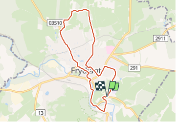
8,5 km | 12,5 km-effort
2h 50min
![](https://static1.geolcdn.com/siteimages/upload/files/16400158638029165_repeat_loop_refresh_sync_direction_icon.png)
Neen
![Tocht Te voet Rynoltice - [Z] Rynoltice -Jitrava - Photo](https://media.geolcdn.com/t/375/260/6d77d54b-5bfe-486d-be52-f4a62639b639.jpeg&format=jpg&maxdim=2)
![Te voet Te voet](https://static1.geolcdn.com/sitytour/trail-icons/100.png)
[Z] Rynoltice -Jitrava
Te voet
Gemakkelijk
Rynoltice,
Noordoost,
Liberecký kraj,
Czech Republic
![](/images/other/stat-length.png)
3,3 km | 3,5 km-effort
47min
![](https://static1.geolcdn.com/siteimages/upload/files/16400158638029165_repeat_loop_refresh_sync_direction_icon.png)
Neen
![Tocht Te voet Jiřetín pod Bukovou - žlutá: Pod Bukovou - Jiřetín pod Bukovou - Photo](https://media.geolcdn.com/t/375/260/7222413c-5b7b-414a-ae41-347397680bb7.jpeg&format=jpg&maxdim=2)
![Te voet Te voet](https://static1.geolcdn.com/sitytour/trail-icons/100.png)
žlutá: Pod Bukovou - Jiřetín pod Bukovou
Te voet
Gemakkelijk
Jiřetín pod Bukovou,
Noordoost,
Liberecký kraj,
Czech Republic
![](/images/other/stat-length.png)
5 km | 8,4 km-effort
1h 55min
![](https://static1.geolcdn.com/siteimages/upload/files/16400158638029165_repeat_loop_refresh_sync_direction_icon.png)
Neen
![Tocht Te voet Tanvald - [Ž] Dolní Smržovka - Příchovice - Photo](https://media.geolcdn.com/t/375/260/4c26dccd-1d48-48a7-8af8-bd60db9f583d.jpeg&format=jpg&maxdim=2)
![Te voet Te voet](https://static1.geolcdn.com/sitytour/trail-icons/100.png)
[Ž] Dolní Smržovka - Příchovice
Te voet
Gemakkelijk
Tanvald,
Noordoost,
Liberecký kraj,
Czech Republic
![](/images/other/stat-length.png)
8,4 km | 16,1 km-effort
3h 39min
![](https://static1.geolcdn.com/siteimages/upload/files/16400158638029165_repeat_loop_refresh_sync_direction_icon.png)
Neen
![Tocht Te voet Kryštofovo Údolí - [M] Výpřež - Novina - Photo](https://media.geolcdn.com/t/375/260/71803f80-2c0c-496d-ad1d-7e0e8f6a53b1.jpeg&format=jpg&maxdim=2)
![Te voet Te voet](https://static1.geolcdn.com/sitytour/trail-icons/100.png)
[M] Výpřež - Novina
Te voet
Gemakkelijk
Kryštofovo Údolí,
Noordoost,
Liberecký kraj,
Czech Republic
![](/images/other/stat-length.png)
4,1 km | 5,4 km-effort
1h 13min
![](https://static1.geolcdn.com/siteimages/upload/files/16400158638029165_repeat_loop_refresh_sync_direction_icon.png)
Neen
![Tocht Te voet Liberec - [Č] Liberec - Bedřichov - Photo](https://media.geolcdn.com/t/375/260/0b60d83f-f733-49d5-8597-509f03ca9ef2.jpeg&format=jpg&maxdim=2)
![Te voet Te voet](https://static1.geolcdn.com/sitytour/trail-icons/100.png)
[Č] Liberec - Bedřichov
Te voet
Gemakkelijk
Liberec,
Noordoost,
Liberecký kraj,
Czech Republic
![](/images/other/stat-length.png)
5,4 km | 9,3 km-effort
2h 6min
![](https://static1.geolcdn.com/siteimages/upload/files/16400158638029165_repeat_loop_refresh_sync_direction_icon.png)
Neen
![Tocht Te voet Hrádek nad Nisou - [M] Hrádek nad Nisou (okruh) - Photo](https://media.geolcdn.com/t/375/260/6f4bfcbc-88e0-401e-bed7-00090c8df757.jpeg&format=jpg&maxdim=2)
![Te voet Te voet](https://static1.geolcdn.com/sitytour/trail-icons/100.png)
[M] Hrádek nad Nisou (okruh)
Te voet
Gemakkelijk
Hrádek nad Nisou,
Noordoost,
Liberecký kraj,
Czech Republic
![](/images/other/stat-length.png)
14,3 km | 19,4 km-effort
4h 24min
![](https://static1.geolcdn.com/siteimages/upload/files/16400158638029165_repeat_loop_refresh_sync_direction_icon.png)
Ja
![Tocht Te voet Jiřetín pod Bukovou - [Z] Tanvald - Jiřetín pod Bukovou - Photo](https://media.geolcdn.com/t/375/260/0e5ae53e-d867-4602-a9f5-30cb743ff205.jpeg&format=jpg&maxdim=2)
![Te voet Te voet](https://static1.geolcdn.com/sitytour/trail-icons/100.png)
[Z] Tanvald - Jiřetín pod Bukovou
Te voet
Gemakkelijk
Jiřetín pod Bukovou,
Noordoost,
Liberecký kraj,
Czech Republic
![](/images/other/stat-length.png)
6,8 km | 10,9 km-effort
2h 28min
![](https://static1.geolcdn.com/siteimages/upload/files/16400158638029165_repeat_loop_refresh_sync_direction_icon.png)
Neen
![Tocht Te voet Kořenov - Tři Iseriny - Photo](https://media.geolcdn.com/t/375/260/ba6763b5-6bf3-40eb-b611-2ada7fa9f3b6.jpeg&format=jpg&maxdim=2)
![Te voet Te voet](https://static1.geolcdn.com/sitytour/trail-icons/100.png)
Tři Iseriny
Te voet
Gemakkelijk
Kořenov,
Noordoost,
Liberecký kraj,
Czech Republic
![](/images/other/stat-length.png)
4,3 km | 5,3 km-effort
1h 12min
![](https://static1.geolcdn.com/siteimages/upload/files/16400158638029165_repeat_loop_refresh_sync_direction_icon.png)
Neen