


3,5 km | 4,6 km-effort
![Tocht Te voet Velké Popovice - [Z] Mnichovice - Velké Popovice - Photo](https://media.geolcdn.com/t/1900/400/8faaf1b9-a244-46f2-93ce-6ca38e41927c.jpeg&format=pjpeg&maxdim=2)

Tous les sentiers balisés d’Europe GUIDE+


Gratisgps-wandelapplicatie
 SityTrail
IGN / Geografische instituten
SityTrail World
De wereld gaat voor u open
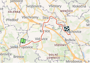
Tocht Te voet van 8,7 km beschikbaar op Centraal-Bohemen, Onbekend, Velké Popovice. Deze tocht wordt voorgesteld door SityTrail - itinéraires balisés pédestres.
Tocht aangemaakt door cz:KČT.
![Tocht Te voet Velké Popovice - [Z] Mnichovice - Velké Popovice - Photo 1](https://media.geolcdn.com/t/2048/auto/df76c639-8db3-4d63-b955-7cb777d2b467.jpeg&format=jpg&maxdim=0 "Tocht Te voet Velké Popovice - [Z] Mnichovice - Velké Popovice - Photo 1")
![Tocht Te voet Velké Popovice - [Z] Mnichovice - Velké Popovice - Photo 2](https://media.geolcdn.com/t/2048/auto/7006ac75-936a-4ab6-8c1c-6746babe1a7c.jpeg&format=jpg&maxdim=0 "Tocht Te voet Velké Popovice - [Z] Mnichovice - Velké Popovice - Photo 2")
![Tocht Te voet Velké Popovice - [Z] Mnichovice - Velké Popovice - Photo 3](https://media.geolcdn.com/t/2048/auto/430ac3fc-b16c-4e62-aa46-e7c878fe355e.jpeg&format=jpg&maxdim=0 "Tocht Te voet Velké Popovice - [Z] Mnichovice - Velké Popovice - Photo 3")
![Tocht Te voet Velké Popovice - [Z] Mnichovice - Velké Popovice - Photo 4](https://media.geolcdn.com/t/2048/auto/1857faed-d8e2-44b7-a248-d4a83869b29f.jpeg&format=jpg&maxdim=0 "Tocht Te voet Velké Popovice - [Z] Mnichovice - Velké Popovice - Photo 4")
![Tocht Te voet Velké Popovice - [Z] Mnichovice - Velké Popovice - Photo 5](https://media.geolcdn.com/t/2048/auto/832f87d0-831a-4859-8a7f-b10649e2a573.jpeg&format=jpg&maxdim=0 "Tocht Te voet Velké Popovice - [Z] Mnichovice - Velké Popovice - Photo 5")
![Tocht Te voet Velké Popovice - [Z] Mnichovice - Velké Popovice - Photo 6](https://media.geolcdn.com/t/2048/auto/c6a97e2a-0ddf-4c7a-b980-a31d8caa707c.jpeg&format=jpg&maxdim=0 "Tocht Te voet Velké Popovice - [Z] Mnichovice - Velké Popovice - Photo 6")
![Tocht Te voet Velké Popovice - [Z] Mnichovice - Velké Popovice - Photo 7](https://media.geolcdn.com/t/2048/auto/62d97ab2-f76c-4f43-a59a-8c69f171485d.jpeg&format=jpg&maxdim=0 "Tocht Te voet Velké Popovice - [Z] Mnichovice - Velké Popovice - Photo 7")
![Tocht Te voet Velké Popovice - [Z] Mnichovice - Velké Popovice - Photo 8](https://media.geolcdn.com/t/2048/auto/3c4d8d2b-5816-4cc2-97d9-d69af15f2f91.jpeg&format=jpg&maxdim=0 "Tocht Te voet Velké Popovice - [Z] Mnichovice - Velké Popovice - Photo 8")
![Tocht Te voet Velké Popovice - [Z] Mnichovice - Velké Popovice - Photo 9](https://media.geolcdn.com/t/2048/auto/29536ee9-6dd0-425e-b9da-b48a31c6bc12.jpeg&format=jpg&maxdim=0 "Tocht Te voet Velké Popovice - [Z] Mnichovice - Velké Popovice - Photo 9")
![Tocht Te voet Velké Popovice - [Z] Mnichovice - Velké Popovice - Photo 10](https://media.geolcdn.com/t/2048/auto/8faaf1b9-a244-46f2-93ce-6ca38e41927c.jpeg&format=jpg&maxdim=0 "Tocht Te voet Velké Popovice - [Z] Mnichovice - Velké Popovice - Photo 10")
![Tocht Te voet Pyšely - [M] Pyšely žst - Pyšely Loreta - Photo](https://media.geolcdn.com/t/375/260/67976ba2-0958-47e5-97b5-e8131ae8a420.jpeg&format=jpg&maxdim=2)
Te voet