


13,3 km | 15,6 km-effort
![Tocht Te voet Střezimíř - [Ž] Střezimíř-Vestec - Photo](https://media.geolcdn.com/t/1900/400/741f7653-64d2-46f3-ad9c-bd79bc7c5f08.jpeg&format=pjpeg&maxdim=2)

Tous les sentiers balisés d’Europe GUIDE+


Gratisgps-wandelapplicatie
 SityTrail
IGN / Geografische instituten
SityTrail World
De wereld gaat voor u open
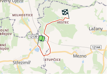
Tocht Te voet van 3,2 km beschikbaar op Centraal-Bohemen, Onbekend, Střezimíř. Deze tocht wordt voorgesteld door SityTrail - itinéraires balisés pédestres.
Tocht aangemaakt door cz:KČT.
![Tocht Te voet Střezimíř - [Ž] Střezimíř-Vestec - Photo 1](https://media.geolcdn.com/t/2048/auto/be3ecb6e-654c-42f1-bcf5-ea8a9b4c6bca.jpeg&format=jpg&maxdim=0 "Tocht Te voet Střezimíř - [Ž] Střezimíř-Vestec - Photo 1")
![Tocht Te voet Střezimíř - [Ž] Střezimíř-Vestec - Photo 2](https://media.geolcdn.com/t/2048/auto/2fcf5bbd-0068-49ca-b15b-277e90fed574.jpeg&format=jpg&maxdim=0 "Tocht Te voet Střezimíř - [Ž] Střezimíř-Vestec - Photo 2")
![Tocht Te voet Střezimíř - [Ž] Střezimíř-Vestec - Photo 3](https://media.geolcdn.com/t/2048/auto/32b6b03d-6a38-4f7e-adfd-267412802d75.jpeg&format=jpg&maxdim=0 "Tocht Te voet Střezimíř - [Ž] Střezimíř-Vestec - Photo 3")
![Tocht Te voet Střezimíř - [Ž] Střezimíř-Vestec - Photo 4](https://media.geolcdn.com/t/2048/auto/bc550865-17c5-4111-9fc5-73d61db8f489.jpeg&format=jpg&maxdim=0 "Tocht Te voet Střezimíř - [Ž] Střezimíř-Vestec - Photo 4")
![Tocht Te voet Střezimíř - [Ž] Střezimíř-Vestec - Photo 5](https://media.geolcdn.com/t/2048/auto/a7f0ed75-18e4-45c5-a82a-ffec02a0d7d8.jpeg&format=jpg&maxdim=0 "Tocht Te voet Střezimíř - [Ž] Střezimíř-Vestec - Photo 5")
![Tocht Te voet Střezimíř - [Ž] Střezimíř-Vestec - Photo 6](https://media.geolcdn.com/t/2048/auto/44206cf0-4f37-48d6-a86c-51cb65db338f.jpeg&format=jpg&maxdim=0 "Tocht Te voet Střezimíř - [Ž] Střezimíř-Vestec - Photo 6")
![Tocht Te voet Střezimíř - [Ž] Střezimíř-Vestec - Photo 7](https://media.geolcdn.com/t/2048/auto/1225aa4f-08c3-4ecb-931a-ef83e0b76ee9.jpeg&format=jpg&maxdim=0 "Tocht Te voet Střezimíř - [Ž] Střezimíř-Vestec - Photo 7")
![Tocht Te voet Střezimíř - [Ž] Střezimíř-Vestec - Photo 8](https://media.geolcdn.com/t/2048/auto/720f4d03-3cfb-4e8c-a7ab-b5cccf46765c.jpeg&format=jpg&maxdim=0 "Tocht Te voet Střezimíř - [Ž] Střezimíř-Vestec - Photo 8")
![Tocht Te voet Střezimíř - [Ž] Střezimíř-Vestec - Photo 9](https://media.geolcdn.com/t/2048/auto/fcacf56e-ab70-46b2-b2c5-5845973030e4.jpeg&format=jpg&maxdim=0 "Tocht Te voet Střezimíř - [Ž] Střezimíř-Vestec - Photo 9")
![Tocht Te voet Střezimíř - [Ž] Střezimíř-Vestec - Photo 10](https://media.geolcdn.com/t/2048/auto/741f7653-64d2-46f3-ad9c-bd79bc7c5f08.jpeg&format=jpg&maxdim=0 "Tocht Te voet Střezimíř - [Ž] Střezimíř-Vestec - Photo 10")
![Tocht Te voet Olbramovice - [Ž] Olbramovice - Maršovice - Photo](https://media.geolcdn.com/t/375/260/fcfa49ac-91dc-4853-bda2-121affd2edcc.jpeg&format=jpg&maxdim=2)
Te voet
![Tocht Te voet Olbramovice - [Ž] Tomice - Postupice - Photo](https://media.geolcdn.com/t/375/260/af13a085-1fa8-46a2-b383-7b15f6a78e93.jpeg&format=jpg&maxdim=2)
Te voet
Te voet
![Tocht Te voet Jankov - [M] Jankov - Šlapánov - Photo](https://media.geolcdn.com/t/375/260/f1e61c24-bcd9-4c3d-8b56-83bf262c1d45.jpeg&format=jpg&maxdim=2)
Te voet
Te voet
![Tocht Te voet Sezimovo Ústí - [M] Sezimovo Ústí - Planá nad Lužnicí - Photo](https://media.geolcdn.com/t/375/260/5b6d0c4e-5d11-4cd9-9c2c-b6cbb176e445.jpeg&format=jpg&maxdim=2)
Te voet
![Tocht Te voet Chotoviny - [Ž] U Obrázku - Sudoměřice - Chotoviny - Photo](https://media.geolcdn.com/t/375/260/f7339841-f981-41ea-8ead-dcdc4c14e1ae.jpeg&format=jpg&maxdim=2)
Te voet
Te voet
![Tocht Te voet Jistebnice - [Č] Padařov - Brtný - Photo](https://media.geolcdn.com/t/375/260/a1483124-2afc-449b-93fd-195f985d667b.jpeg&format=jpg&maxdim=2)
Te voet