


38 km | 46 km-effort
![Tocht Te voet Štěchovice - [Z] Pod Homolí - Třebenice - Photo](https://media.geolcdn.com/t/1900/400/f74490da-eba5-420f-ba19-f5f256693f47.jpeg&format=pjpeg&maxdim=2)

Tous les sentiers balisés d’Europe GUIDE+


Gratisgps-wandelapplicatie
 SityTrail
IGN / Geografische instituten
SityTrail World
De wereld gaat voor u open
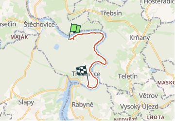
Tocht Te voet van 7 km beschikbaar op Centraal-Bohemen, Onbekend, Štěchovice. Deze tocht wordt voorgesteld door SityTrail - itinéraires balisés pédestres.
Tocht aangemaakt door cz:KČT.
![Tocht Te voet Štěchovice - [Z] Pod Homolí - Třebenice - Photo 1](https://media.geolcdn.com/t/2048/auto/f351c5c6-13a2-4568-b8ce-12ee0369864f.jpeg&format=jpg&maxdim=0 "Tocht Te voet Štěchovice - [Z] Pod Homolí - Třebenice - Photo 1")
![Tocht Te voet Štěchovice - [Z] Pod Homolí - Třebenice - Photo 2](https://media.geolcdn.com/t/2048/auto/82338e24-aedb-442f-8158-e05351ddc631.jpeg&format=jpg&maxdim=0 "Tocht Te voet Štěchovice - [Z] Pod Homolí - Třebenice - Photo 2")
![Tocht Te voet Štěchovice - [Z] Pod Homolí - Třebenice - Photo 3](https://media.geolcdn.com/t/2048/auto/cec0cdea-a1a1-4267-9d82-021ef811f4d9.jpeg&format=jpg&maxdim=0 "Tocht Te voet Štěchovice - [Z] Pod Homolí - Třebenice - Photo 3")
![Tocht Te voet Štěchovice - [Z] Pod Homolí - Třebenice - Photo 4](https://media.geolcdn.com/t/2048/auto/13f6f053-7b21-4e59-ab9e-b4a7571a6915.jpeg&format=jpg&maxdim=0 "Tocht Te voet Štěchovice - [Z] Pod Homolí - Třebenice - Photo 4")
![Tocht Te voet Štěchovice - [Z] Pod Homolí - Třebenice - Photo 5](https://media.geolcdn.com/t/2048/auto/f313f7be-d7a6-42fb-b7d9-1fe1bdd0d7bf.jpeg&format=jpg&maxdim=0 "Tocht Te voet Štěchovice - [Z] Pod Homolí - Třebenice - Photo 5")
![Tocht Te voet Štěchovice - [Z] Pod Homolí - Třebenice - Photo 6](https://media.geolcdn.com/t/2048/auto/afb45f6f-dd17-43e5-abdd-e48e082467a0.jpeg&format=jpg&maxdim=0 "Tocht Te voet Štěchovice - [Z] Pod Homolí - Třebenice - Photo 6")
![Tocht Te voet Štěchovice - [Z] Pod Homolí - Třebenice - Photo 7](https://media.geolcdn.com/t/2048/auto/559784aa-5819-48b4-a86c-c19550ad48a0.jpeg&format=jpg&maxdim=0 "Tocht Te voet Štěchovice - [Z] Pod Homolí - Třebenice - Photo 7")
![Tocht Te voet Štěchovice - [Z] Pod Homolí - Třebenice - Photo 8](https://media.geolcdn.com/t/2048/auto/6210268d-1af4-4da8-aac3-6c7423f75e3c.jpeg&format=jpg&maxdim=0 "Tocht Te voet Štěchovice - [Z] Pod Homolí - Třebenice - Photo 8")
![Tocht Te voet Štěchovice - [Z] Pod Homolí - Třebenice - Photo 9](https://media.geolcdn.com/t/2048/auto/a87c203b-f7c4-4fd9-acf4-ea9622862289.jpeg&format=jpg&maxdim=0 "Tocht Te voet Štěchovice - [Z] Pod Homolí - Třebenice - Photo 9")
![Tocht Te voet Štěchovice - [Z] Pod Homolí - Třebenice - Photo 10](https://media.geolcdn.com/t/2048/auto/f74490da-eba5-420f-ba19-f5f256693f47.jpeg&format=jpg&maxdim=0 "Tocht Te voet Štěchovice - [Z] Pod Homolí - Třebenice - Photo 10")

Auto

Motorboot
![Tocht Te voet Bojanovice - [Z] Štěchovice - Nový Knín - Photo](https://media.geolcdn.com/t/375/260/3abfdc1c-a054-4737-a058-bae860c04258.jpeg&format=jpg&maxdim=2)
Te voet
Te voet
![Tocht Te voet Krňany - [Z] Pikovice - Pod Třebsínem - Photo](https://media.geolcdn.com/t/375/260/9d973daa-efdc-425c-b30b-77795e7c71fa.jpeg&format=jpg&maxdim=2)
Te voet
![Tocht Te voet Kamenný Přívoz - [M] Štěchovice-Žampach - Photo](https://media.geolcdn.com/t/375/260/a821c811-bd4f-4f8f-981b-9700e5481d50.jpeg&format=jpg&maxdim=2)
Te voet
![Tocht Te voet Kamenný Přívoz - [Ž] Jílové-Žampach - Photo](https://media.geolcdn.com/t/375/260/434c63fc-6fe3-4b0a-b856-0b7d89cd0676.jpeg&format=jpg&maxdim=2)
Te voet
![Tocht Te voet Davle - [Ž] Davle - Jílové u P. - Photo](https://media.geolcdn.com/t/375/260/565e6ba4-c226-4a61-be53-789e63a62320.jpeg&format=jpg&maxdim=2)
Te voet
![Tocht Te voet Jílové u Prahy - [M] Luka pod Medníkem - Těptín - Photo](https://media.geolcdn.com/t/375/260/13918b73-d9c0-43e5-94f7-fc0ab83a603d.jpeg&format=jpg&maxdim=2)
Te voet