


27 km | 32 km-effort
![Tocht Te voet Vražkov - [Ž] Vražkov - Říp - Photo](https://media.geolcdn.com/t/1900/400/d4939c62-d69f-4f63-89b2-bb6f19e39c54.jpeg&format=pjpeg&maxdim=2)

Tous les sentiers balisés d’Europe GUIDE+


Gratisgps-wandelapplicatie
 SityTrail
IGN / Geografische instituten
SityTrail World
De wereld gaat voor u open
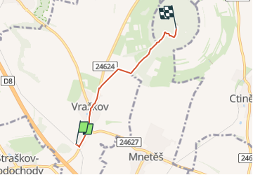
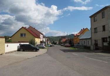
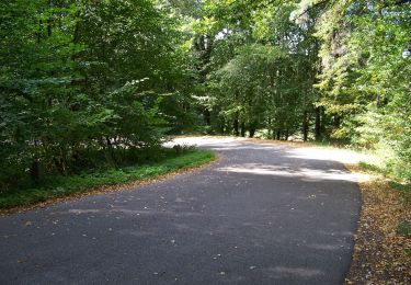
Tocht Te voet van 3,2 km beschikbaar op Noordwest, Ústecký kraj, Vražkov. Deze tocht wordt voorgesteld door SityTrail - itinéraires balisés pédestres.
Tocht aangemaakt door cz:KČT.
![Tocht Te voet Vražkov - [Ž] Vražkov - Říp - Photo 1](https://media.geolcdn.com/t/2048/auto/30d23366-1158-4ad0-be00-0ebb8ba435d1.jpeg&format=jpg&maxdim=0 "Tocht Te voet Vražkov - [Ž] Vražkov - Říp - Photo 1")
![Tocht Te voet Vražkov - [Ž] Vražkov - Říp - Photo 2](https://media.geolcdn.com/t/2048/auto/7a226d8a-9ea2-4732-946e-4026b499a2ac.jpeg&format=jpg&maxdim=0 "Tocht Te voet Vražkov - [Ž] Vražkov - Říp - Photo 2")
![Tocht Te voet Vražkov - [Ž] Vražkov - Říp - Photo 3](https://media.geolcdn.com/t/2048/auto/712ece0e-7929-413a-adcb-b9bab1ebcf3c.jpeg&format=jpg&maxdim=0 "Tocht Te voet Vražkov - [Ž] Vražkov - Říp - Photo 3")
![Tocht Te voet Vražkov - [Ž] Vražkov - Říp - Photo 4](https://media.geolcdn.com/t/2048/auto/d19780d2-7319-42f5-87db-1151e47dd5db.jpeg&format=jpg&maxdim=0 "Tocht Te voet Vražkov - [Ž] Vražkov - Říp - Photo 4")
![Tocht Te voet Vražkov - [Ž] Vražkov - Říp - Photo 5](https://media.geolcdn.com/t/2048/auto/211761f3-ba10-46b4-a6f6-978cf40ae1fb.jpeg&format=jpg&maxdim=0 "Tocht Te voet Vražkov - [Ž] Vražkov - Říp - Photo 5")
![Tocht Te voet Vražkov - [Ž] Vražkov - Říp - Photo 6](https://media.geolcdn.com/t/2048/auto/df5e7eb1-f910-41c4-adf8-5bc60223666b.jpeg&format=jpg&maxdim=0 "Tocht Te voet Vražkov - [Ž] Vražkov - Říp - Photo 6")
![Tocht Te voet Vražkov - [Ž] Vražkov - Říp - Photo 7](https://media.geolcdn.com/t/2048/auto/099477a4-d6d2-4f08-8776-0e853a173ce6.jpeg&format=jpg&maxdim=0 "Tocht Te voet Vražkov - [Ž] Vražkov - Říp - Photo 7")
![Tocht Te voet Vražkov - [Ž] Vražkov - Říp - Photo 8](https://media.geolcdn.com/t/2048/auto/c6357435-7875-4ac1-9691-7d3ee5fbbd69.jpeg&format=jpg&maxdim=0 "Tocht Te voet Vražkov - [Ž] Vražkov - Říp - Photo 8")
![Tocht Te voet Vražkov - [Ž] Vražkov - Říp - Photo 9](https://media.geolcdn.com/t/2048/auto/a0b42fa3-5806-487d-90b0-354237e8cf95.jpeg&format=jpg&maxdim=0 "Tocht Te voet Vražkov - [Ž] Vražkov - Říp - Photo 9")
![Tocht Te voet Vražkov - [Ž] Vražkov - Říp - Photo 10](https://media.geolcdn.com/t/2048/auto/d4939c62-d69f-4f63-89b2-bb6f19e39c54.jpeg&format=jpg&maxdim=0 "Tocht Te voet Vražkov - [Ž] Vražkov - Říp - Photo 10")
![Tocht Te voet Mělník - [Z] Mělník - okružní trasa - Photo](https://media.geolcdn.com/t/375/260/e6c96ca9-333e-4cf1-8b0e-018ae508ba3d.jpeg&format=jpg&maxdim=2)
Te voet
![Tocht Te voet Želízy - [M] Kokořín - Zimořský důl - Photo](https://media.geolcdn.com/t/375/260/04ffd1a5-afe9-4e85-be18-0b7b38d70abe.jpeg&format=jpg&maxdim=2)
Te voet
![Tocht Te voet Litoměřice - [Z] Sebuzín - Litoměřice - Photo](https://media.geolcdn.com/t/375/260/d13b5b00-8ae2-4a20-b537-a715ffb460bd.jpeg&format=jpg&maxdim=2)
Te voet
![Tocht Te voet Litoměřice - [Ž] Litoměřice - Žalhostice - Photo](https://media.geolcdn.com/t/375/260/8bc79a50-05ba-402a-b3dd-c0eb686c9585.jpeg&format=jpg&maxdim=2)
Te voet
Te voet
![Tocht Te voet Velemín - [Z] Lovosice - Lovoš - Photo](https://media.geolcdn.com/t/375/260/56729d64-92f9-4f1a-b306-435d360c3945.jpeg&format=jpg&maxdim=2)
Te voet
![Tocht Te voet Vchynice - [Z] Košťálov - Vchynice - Photo](https://media.geolcdn.com/t/375/260/cbddb818-5cb7-4bbf-a7f5-8e82eee1571b.jpeg&format=jpg&maxdim=2)
Te voet
Te voet
![Tocht Te voet Želízy - [Ž] Želízy - Štětí - Photo](https://media.geolcdn.com/t/375/260/5fe56eac-7584-4af0-9a4b-860224c197e4.jpeg&format=jpg&maxdim=2)
Te voet