


8,2 km | 11,1 km-effort
![Tocht Te voet Jíloviště - [Ž] Jíloviště - Černošice - Photo](https://media.geolcdn.com/t/1900/400/658263c1-3fcf-44eb-9c17-2cb3a74b2689.jpeg&format=pjpeg&maxdim=2)

Tous les sentiers balisés d’Europe GUIDE+


Gratisgps-wandelapplicatie
 SityTrail
IGN / Geografische instituten
SityTrail World
De wereld gaat voor u open
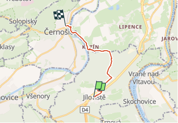
Tocht Te voet van 6,3 km beschikbaar op Centraal-Bohemen, Onbekend, Jíloviště. Deze tocht wordt voorgesteld door SityTrail - itinéraires balisés pédestres.
Tocht aangemaakt door cz:KČT.
![Tocht Te voet Jíloviště - [Ž] Jíloviště - Černošice - Photo 1](https://media.geolcdn.com/t/2048/auto/c6571ba8-d7c7-43df-9c6e-81a05993bb16.jpeg&format=jpg&maxdim=0 "Tocht Te voet Jíloviště - [Ž] Jíloviště - Černošice - Photo 1")
![Tocht Te voet Jíloviště - [Ž] Jíloviště - Černošice - Photo 2](https://media.geolcdn.com/t/2048/auto/11d616f4-c52a-477a-ab4a-ce6ba1d23915.jpeg&format=jpg&maxdim=0 "Tocht Te voet Jíloviště - [Ž] Jíloviště - Černošice - Photo 2")
![Tocht Te voet Jíloviště - [Ž] Jíloviště - Černošice - Photo 3](https://media.geolcdn.com/t/2048/auto/5d0b0d58-2238-42bd-b137-8eb9d7b8e6b0.jpeg&format=jpg&maxdim=0 "Tocht Te voet Jíloviště - [Ž] Jíloviště - Černošice - Photo 3")
![Tocht Te voet Jíloviště - [Ž] Jíloviště - Černošice - Photo 4](https://media.geolcdn.com/t/2048/auto/fdb98ca1-25ff-4eed-bc0c-08854138b987.jpeg&format=jpg&maxdim=0 "Tocht Te voet Jíloviště - [Ž] Jíloviště - Černošice - Photo 4")
![Tocht Te voet Jíloviště - [Ž] Jíloviště - Černošice - Photo 5](https://media.geolcdn.com/t/2048/auto/cf9a336d-686b-4f84-8b9e-910cdcdb1952.jpeg&format=jpg&maxdim=0 "Tocht Te voet Jíloviště - [Ž] Jíloviště - Černošice - Photo 5")
![Tocht Te voet Jíloviště - [Ž] Jíloviště - Černošice - Photo 6](https://media.geolcdn.com/t/2048/auto/d447a15d-03ac-4762-b21c-ec2bea0a3ac7.jpeg&format=jpg&maxdim=0 "Tocht Te voet Jíloviště - [Ž] Jíloviště - Černošice - Photo 6")
![Tocht Te voet Jíloviště - [Ž] Jíloviště - Černošice - Photo 7](https://media.geolcdn.com/t/2048/auto/b865acf0-2a60-4f2f-9f08-20e9f93a1252.jpeg&format=jpg&maxdim=0 "Tocht Te voet Jíloviště - [Ž] Jíloviště - Černošice - Photo 7")
![Tocht Te voet Jíloviště - [Ž] Jíloviště - Černošice - Photo 8](https://media.geolcdn.com/t/2048/auto/ad965365-0ccf-4823-b49c-f48137024316.jpeg&format=jpg&maxdim=0 "Tocht Te voet Jíloviště - [Ž] Jíloviště - Černošice - Photo 8")
![Tocht Te voet Jíloviště - [Ž] Jíloviště - Černošice - Photo 9](https://media.geolcdn.com/t/2048/auto/1fa0c044-3cf2-4d5f-8d40-269e1f4bbda8.jpeg&format=jpg&maxdim=0 "Tocht Te voet Jíloviště - [Ž] Jíloviště - Černošice - Photo 9")
![Tocht Te voet Jíloviště - [Ž] Jíloviště - Černošice - Photo 10](https://media.geolcdn.com/t/2048/auto/658263c1-3fcf-44eb-9c17-2cb3a74b2689.jpeg&format=jpg&maxdim=0 "Tocht Te voet Jíloviště - [Ž] Jíloviště - Černošice - Photo 10")
![Tocht Te voet Měchenice - [M] Měchenice - Všenory - Photo](https://media.geolcdn.com/t/375/260/06630537-e029-451b-a301-b274a78a918c.jpeg&format=jpg&maxdim=2)
Te voet
Te voet
Te voet
![Tocht Te voet - [Z] Zbraslav-Dolní Břežany - Photo](https://media.geolcdn.com/t/375/260/b4e52e59-239c-42d8-8ce8-b4792227119d.jpeg&format=jpg&maxdim=2)
Te voet
![Tocht Te voet Dobřichovice - [Z] Dobřichovice-Třebotov-Černošice - Photo](https://media.geolcdn.com/t/375/260/658263c1-3fcf-44eb-9c17-2cb3a74b2689.jpeg&format=jpg&maxdim=2)
Te voet
![Tocht Te voet Zvole - [Ž] Vrané - Ohrobská - Photo](https://media.geolcdn.com/t/375/260/2b998145-2f51-4216-98cc-0d1c0929ad72.jpeg&format=jpg&maxdim=2)
Te voet
![Tocht Te voet Davle - [Ž] Davle - Jílové u P. - Photo](https://media.geolcdn.com/t/375/260/565e6ba4-c226-4a61-be53-789e63a62320.jpeg&format=jpg&maxdim=2)
Te voet
![Tocht Te voet Černošice - [M] Černošice - Dub sedmi bratří - Photo](https://media.geolcdn.com/t/375/260/b3245b35-2206-4973-a671-0f64caf56378.jpeg&format=jpg&maxdim=2)
Te voet