


11,2 km | 13 km-effort
![Tocht Te voet Unknown - [M] Klánovice-Uhříněves - Photo](https://media.geolcdn.com/t/1900/400/625eae54-70bc-435a-bd59-da7017d51f0c.jpeg&format=pjpeg&maxdim=2)

Tous les sentiers balisés d’Europe GUIDE+


Gratisgps-wandelapplicatie
 SityTrail
IGN / Geografische instituten
SityTrail World
De wereld gaat voor u open
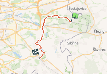
Tocht Te voet van 16,1 km beschikbaar op Praha, Praag. Deze tocht wordt voorgesteld door SityTrail - itinéraires balisés pédestres.
Tocht aangemaakt door cz:KČT.
![Tocht Te voet Unknown - [M] Klánovice-Uhříněves - Photo 1](https://media.geolcdn.com/t/2048/auto/5b7059bf-fe2f-4e20-971e-8e2b6ee4517f.jpeg&format=jpg&maxdim=0 "Tocht Te voet Unknown - [M] Klánovice-Uhříněves - Photo 1")
![Tocht Te voet Unknown - [M] Klánovice-Uhříněves - Photo 2](https://media.geolcdn.com/t/2048/auto/352ba570-365c-4413-845a-cd38e6341012.jpeg&format=jpg&maxdim=0 "Tocht Te voet Unknown - [M] Klánovice-Uhříněves - Photo 2")
![Tocht Te voet Unknown - [M] Klánovice-Uhříněves - Photo 3](https://media.geolcdn.com/t/2048/auto/f8c1ce1a-6065-4db8-b26d-b3fe846f4b43.jpeg&format=jpg&maxdim=0 "Tocht Te voet Unknown - [M] Klánovice-Uhříněves - Photo 3")
![Tocht Te voet Unknown - [M] Klánovice-Uhříněves - Photo 4](https://media.geolcdn.com/t/2048/auto/62678720-d73a-4c76-9a9e-dfd6b8ce3c1c.jpeg&format=jpg&maxdim=0 "Tocht Te voet Unknown - [M] Klánovice-Uhříněves - Photo 4")
![Tocht Te voet Unknown - [M] Klánovice-Uhříněves - Photo 5](https://media.geolcdn.com/t/2048/auto/01e3beec-bc33-4897-8252-931fd1d827a6.jpeg&format=jpg&maxdim=0 "Tocht Te voet Unknown - [M] Klánovice-Uhříněves - Photo 5")
![Tocht Te voet Unknown - [M] Klánovice-Uhříněves - Photo 6](https://media.geolcdn.com/t/2048/auto/523620b0-86ad-4347-8c14-877757b81a9f.jpeg&format=jpg&maxdim=0 "Tocht Te voet Unknown - [M] Klánovice-Uhříněves - Photo 6")
![Tocht Te voet Unknown - [M] Klánovice-Uhříněves - Photo 7](https://media.geolcdn.com/t/2048/auto/cd2adbe2-5722-48f0-9ee9-4b9f8e86857c.jpeg&format=jpg&maxdim=0 "Tocht Te voet Unknown - [M] Klánovice-Uhříněves - Photo 7")
![Tocht Te voet Unknown - [M] Klánovice-Uhříněves - Photo 8](https://media.geolcdn.com/t/2048/auto/c68a7f13-70e3-4b9c-9362-ea8b5afb5084.jpeg&format=jpg&maxdim=0 "Tocht Te voet Unknown - [M] Klánovice-Uhříněves - Photo 8")
![Tocht Te voet Unknown - [M] Klánovice-Uhříněves - Photo 9](https://media.geolcdn.com/t/2048/auto/29d45021-9529-4edf-bafd-ccce8303a215.jpeg&format=jpg&maxdim=0 "Tocht Te voet Unknown - [M] Klánovice-Uhříněves - Photo 9")
![Tocht Te voet Unknown - [M] Klánovice-Uhříněves - Photo 10](https://media.geolcdn.com/t/2048/auto/625eae54-70bc-435a-bd59-da7017d51f0c.jpeg&format=jpg&maxdim=0 "Tocht Te voet Unknown - [M] Klánovice-Uhříněves - Photo 10")
![Tocht Te voet - [Č] Uhříněves-Běchovice - Photo](https://media.geolcdn.com/t/375/260/625eae54-70bc-435a-bd59-da7017d51f0c.jpeg&format=jpg&maxdim=2)
Te voet
Te voet
![Tocht Te voet - [Č] Běchovice-Úvaly - Photo](https://media.geolcdn.com/t/375/260/1e5c4a6d-a086-48d0-985d-e933c545c471.jpeg&format=jpg&maxdim=2)
Te voet
![Tocht Te voet - [Z] Klánovice - okružní trasa - Photo](https://media.geolcdn.com/t/375/260/9c6d29df-bba0-4cdc-ad39-46418b50c165.jpeg&format=jpg&maxdim=2)
Te voet