![](/images/other/stat-length.png)
![Tocht Stappen Caumont-sur-Durance - Rando repas - Caumont - Chateauneuf de Gadagne - le 06 02 2025 - Photo](https://media.geolcdn.com/t/1900/400/b3515347-9be0-4a57-ac51-a2e967be135c.jpg&format=pjpeg&maxdim=2)
Rando repas - Caumont - Chateauneuf de Gadagne - le 06 02 2025
Loli27
Gebruiker
![Lengte](/images/other/stat-length.png)
Lengte
10,6 km
![Max. hoogte](https://static1.geolcdn.com/siteimages/upload/files/1508320355ic_sort_altitude_max_24dp.png)
Max. hoogte
124 m
![Positief hoogteverschil](https://static1.geolcdn.com/siteimages/upload/files/1508320355ic_sort_den_pos_24dp.png)
Positief hoogteverschil
181 m
![Km-Effort](/images/other/stat-length.png)
Km-Effort
13,1 km
![Min. hoogte](https://static1.geolcdn.com/siteimages/upload/files/1508320355ic_sort_altitude_min_24dp.png)
Min. hoogte
45 m
![Negatief hoogteverschil](https://static1.geolcdn.com/siteimages/upload/files/1508320355ic_sort_den_neg_24dp.png)
Negatief hoogteverschil
181 m
![Boucle](https://static1.geolcdn.com/siteimages/upload/files/16400158638029165_repeat_loop_refresh_sync_direction_icon.png)
Boucle
Ja
Datum van aanmaak :
2025-02-06 09:21:43.835
Laatste wijziging :
2025-02-08 17:16:45.43
![Stappen](https://static1.geolcdn.com/sitytour/trail-icons/101.png)
2h58
Moeilijkheid : Moeilijk
![Scan deze QR-code om de tocht te openen in de SityTrail-applicatie](https://capi.geolives.com/qq0zvz2zws4bq2lad0pu/sitytour/trails/4343524/qr.png?size=200)
Gratisgps-wandelapplicatie
Over ons
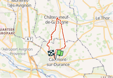
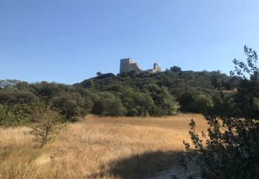
Tocht Stappen van 10,6 km beschikbaar op Provence-Alpes-Côte d'Azur, Vaucluse, Caumont-sur-Durance. Deze tocht wordt voorgesteld door Loli27.
Beschrijving
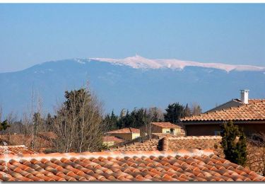
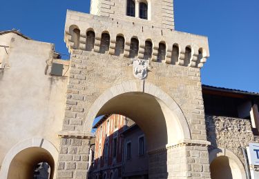
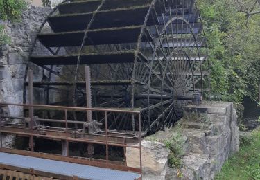
Rando repas resto "Celou" Chateuneuf de Gadagne
jeudi 06 février 2025 guidée par Jean Luc et Cathy. Nous étions 24.
Plaatsbepaling
Land:
France
Regio :
Provence-Alpes-Côte d'Azur
Departement/Provincie :
Vaucluse
Gemeente :
Caumont-sur-Durance
Locatie:
Unknown
Vertrek:(Dec)
Vertrek:(UTM)
656061 ; 4862087 (31T) N.
Opmerkingen
Wandeltochten in de omgeving
![Tocht Fiets Le Thor - Circuit Vélo - Balade sur les rives de la Sorgue - Le Thor - Photo](https://media.geolcdn.com/t/375/260/ext.jpg?maxdim=2&url=https%3A%2F%2Fservices.sitytrail.com%2FGeolivesWS%2FDownloadMedia.ashx%3FTrailID%3D118768%26Media%3D12965_5.jpg)
![Fiets Fiets](https://static1.geolcdn.com/sitytour/trail-icons/200.png)
Circuit Vélo - Balade sur les rives de la Sorgue - Le Thor
Fiets
Medium
(1)
Le Thor,
Provence-Alpes-Côte d'Azur,
Vaucluse,
France
![](/images/other/stat-length.png)
24 km | 25 km-effort
2h 15min
![](https://static1.geolcdn.com/siteimages/upload/files/16400158638029165_repeat_loop_refresh_sync_direction_icon.png)
Ja
![Tocht Hybride fiets Le Thor - Autour de la Sorgues - Photo](https://media.geolcdn.com/t/375/260/00a2aad6-7f0c-4fb7-a38d-e9113690acce.jpg&format=jpg&maxdim=2)
![Hybride fiets Hybride fiets](https://static1.geolcdn.com/sitytour/trail-icons/203.png)
Autour de la Sorgues
Hybride fiets
Moeilijk
Le Thor,
Provence-Alpes-Côte d'Azur,
Vaucluse,
France
![](/images/other/stat-length.png)
45 km | 50 km-effort
3h 27min
![](https://static1.geolcdn.com/siteimages/upload/files/16400158638029165_repeat_loop_refresh_sync_direction_icon.png)
Ja
![Tocht Stappen Le Thor - Autour de Thor château de Thouzon - Photo](https://media.geolcdn.com/t/375/260/75525555-cf65-4cb8-890a-434d58a7d426.jpg&format=jpg&maxdim=2)
![Stappen Stappen](https://static1.geolcdn.com/sitytour/trail-icons/101.png)
Autour de Thor château de Thouzon
Stappen
Gemakkelijk
Le Thor,
Provence-Alpes-Côte d'Azur,
Vaucluse,
France
![](/images/other/stat-length.png)
7,8 km | 9 km-effort
2h 12min
![](https://static1.geolcdn.com/siteimages/upload/files/16400158638029165_repeat_loop_refresh_sync_direction_icon.png)
Ja
![Tocht Stappen Le Thor - LE THOR - THOUZON - Photo](https://media.geolcdn.com/t/375/260/ea78f151-90aa-40e5-9a1b-69fcb96d9be6.jpg&format=jpg&maxdim=2)
![Stappen Stappen](https://static1.geolcdn.com/sitytour/trail-icons/101.png)
LE THOR - THOUZON
Stappen
Le Thor,
Provence-Alpes-Côte d'Azur,
Vaucluse,
France
![](/images/other/stat-length.png)
7,2 km | 8,5 km-effort
2h 1min
![](https://static1.geolcdn.com/siteimages/upload/files/16400158638029165_repeat_loop_refresh_sync_direction_icon.png)
Ja
![Tocht Stappen Caumont-sur-Durance - Les Hauteurs de Caumont - Photo](https://media.geolcdn.com/t/375/260/2a1bd239-2607-4202-a026-2c2affd8ae94.jpg&format=jpg&maxdim=2)
![Stappen Stappen](https://static1.geolcdn.com/sitytour/trail-icons/101.png)
Les Hauteurs de Caumont
Stappen
Medium
Caumont-sur-Durance,
Provence-Alpes-Côte d'Azur,
Vaucluse,
France
![](/images/other/stat-length.png)
5,8 km | 7,8 km-effort
1h 46min
![](https://static1.geolcdn.com/siteimages/upload/files/16400158638029165_repeat_loop_refresh_sync_direction_icon.png)
Ja
![Tocht Stappen Le Thor - autour de Thouzon - Photo](https://media.geolcdn.com/t/375/260/610608c8-59ef-45e3-9912-b6aaa8193d96.jpg&format=jpg&maxdim=2)
![Stappen Stappen](https://static1.geolcdn.com/sitytour/trail-icons/101.png)
autour de Thouzon
Stappen
Heel gemakkelijk
(1)
Le Thor,
Provence-Alpes-Côte d'Azur,
Vaucluse,
France
![](/images/other/stat-length.png)
8,9 km | 10,3 km-effort
2h 40min
![](https://static1.geolcdn.com/siteimages/upload/files/16400158638029165_repeat_loop_refresh_sync_direction_icon.png)
Ja
![Tocht Fiets Châteauneuf-de-Gadagne - Circuit Vélo - Entre vignobles et vergers au pays des Sorgues - Châteauneuf de Gadagne - Photo](https://media.geolcdn.com/t/375/260/ext.jpg?maxdim=2&url=https%3A%2F%2Fservices.sitytrail.com%2FGeolivesWS%2FDownloadMedia.ashx%3FTrailID%3D111830%26Media%3D8519_1.jpg)
![Fiets Fiets](https://static1.geolcdn.com/sitytour/trail-icons/200.png)
Circuit Vélo - Entre vignobles et vergers au pays des Sorgues - Châteauneuf d...
Fiets
Medium
(2)
Châteauneuf-de-Gadagne,
Provence-Alpes-Côte d'Azur,
Vaucluse,
France
![](/images/other/stat-length.png)
14,6 km | 15,6 km-effort
1h 15min
![](https://static1.geolcdn.com/siteimages/upload/files/16400158638029165_repeat_loop_refresh_sync_direction_icon.png)
Ja
![Tocht Wegfiets Noves - Les palus de nove - Photo](https://media.geolcdn.com/t/375/260/ext.jpg?maxdim=2&url=https%3A%2F%2Fstatic1.geolcdn.com%2Fsiteimages%2Fupload%2Ffiles%2F1524743154velo.jpg)
![Wegfiets Wegfiets](https://static1.geolcdn.com/sitytour/trail-icons/201.png)
Les palus de nove
Wegfiets
Gemakkelijk
Noves,
Provence-Alpes-Côte d'Azur,
Bouches-du-Rhône,
France
![](/images/other/stat-length.png)
4,7 km | 5 km-effort
19min
![](https://static1.geolcdn.com/siteimages/upload/files/16400158638029165_repeat_loop_refresh_sync_direction_icon.png)
Neen
![Tocht Fietstoerisme Caumont-sur-Durance - Vélo - Caumont, Noves, Eyragues, St Rémy, Mollégès, Noves, Caumont par nouvelle piste cyclable St Rémy Molléges - Photo](https://media.geolcdn.com/t/375/260/ext.jpg?maxdim=2&url=https%3A%2F%2Fstatic1.geolcdn.com%2Fsiteimages%2Fupload%2Ffiles%2F1524743154velo.jpg)
![Fietstoerisme Fietstoerisme](https://static1.geolcdn.com/sitytour/trail-icons/204.png)
Vélo - Caumont, Noves, Eyragues, St Rémy, Mollégès, Noves, Caumont par nouvel...
Fietstoerisme
Medium
(1)
Caumont-sur-Durance,
Provence-Alpes-Côte d'Azur,
Vaucluse,
France
![](/images/other/stat-length.png)
46 km | 50 km-effort
3h 37min
![](https://static1.geolcdn.com/siteimages/upload/files/16400158638029165_repeat_loop_refresh_sync_direction_icon.png)
Ja