![](/images/other/stat-length.png)
![Tocht Te voet The Municipal District of Castlecomer - Walled Garden Loop - Photo](https://media.geolcdn.com/t/1900/400/4a1a37e0-9442-4b56-96a2-daeab4fd671e.jpeg&format=pjpeg&maxdim=2)
Walled Garden Loop
SityTrail - itinéraires balisés pédestres
Tous les sentiers balisés d’Europe GUIDE+
![Lengte](/images/other/stat-length.png)
Lengte
3,3 km
![Max. hoogte](https://static1.geolcdn.com/siteimages/upload/files/1508320355ic_sort_altitude_max_24dp.png)
Max. hoogte
111 m
![Positief hoogteverschil](https://static1.geolcdn.com/siteimages/upload/files/1508320355ic_sort_den_pos_24dp.png)
Positief hoogteverschil
51 m
![Km-Effort](/images/other/stat-length.png)
Km-Effort
4 km
![Min. hoogte](https://static1.geolcdn.com/siteimages/upload/files/1508320355ic_sort_altitude_min_24dp.png)
Min. hoogte
71 m
![Negatief hoogteverschil](https://static1.geolcdn.com/siteimages/upload/files/1508320355ic_sort_den_neg_24dp.png)
Negatief hoogteverschil
50 m
![Boucle](https://static1.geolcdn.com/siteimages/upload/files/16400158638029165_repeat_loop_refresh_sync_direction_icon.png)
Boucle
Ja
Markering
Datum van aanmaak :
2025-02-06 12:18:27.315
Laatste wijziging :
2025-02-06 12:18:27.315
![Te voet](https://static1.geolcdn.com/sitytour/trail-icons/100.png)
54m
Moeilijkheid : Gemakkelijk
![Scan deze QR-code om de tocht te openen in de SityTrail-applicatie](https://capi.geolives.com/qq0zvz2zws4bq2lad0pu/sitytour/trails/4342820/qr.png?size=200)
Gratisgps-wandelapplicatie
Over ons
Tocht Te voet van 3,3 km beschikbaar op Onbekend, County Kilkenny, The Municipal District of Castlecomer. Deze tocht wordt voorgesteld door SityTrail - itinéraires balisés pédestres.
Beschrijving
Tocht aangemaakt door Trail Kilkenny.
Website: http://www.trailkilkenny.ie/walking-trails/jenkinstown/
Plaatsbepaling
Land:
Ireland
Regio :
Onbekend
Departement/Provincie :
County Kilkenny
Gemeente :
The Municipal District of Castlecomer
Locatie:
Coolcraheen
Vertrek:(Dec)
Vertrek:(UTM)
615525 ; 5843713 (29U) N.
Opmerkingen
Wandeltochten in de omgeving
![Tocht Te voet The Municipal District of Kilkenny City - Nore Valley Walk - Photo](https://media.geolcdn.com/t/375/260/a0795b87-0de1-473a-bc60-47bc8f0672e3.jpeg&format=jpg&maxdim=2)
![Te voet Te voet](https://static1.geolcdn.com/sitytour/trail-icons/100.png)
Nore Valley Walk
Te voet
Gemakkelijk
The Municipal District of Kilkenny City,
Onbekend,
County Kilkenny,
Ireland
![](/images/other/stat-length.png)
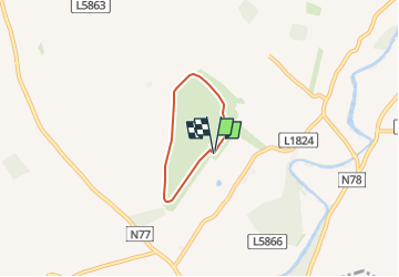
9,6 km | 10,3 km-effort
2h 19min
![](https://static1.geolcdn.com/siteimages/upload/files/16400158638029165_repeat_loop_refresh_sync_direction_icon.png)
Neen
![Tocht Te voet The Municipal District of Castlecomer - Freshford Loop - Photo](https://media.geolcdn.com/t/375/260/50bfc5d3-5171-42cf-830c-51732b3995e3.jpeg&format=jpg&maxdim=2)
![Te voet Te voet](https://static1.geolcdn.com/sitytour/trail-icons/100.png)
Freshford Loop
Te voet
Gemakkelijk
The Municipal District of Castlecomer,
Onbekend,
County Kilkenny,
Ireland
![](/images/other/stat-length.png)
5,8 km | 6,9 km-effort
1h 34min
![](https://static1.geolcdn.com/siteimages/upload/files/16400158638029165_repeat_loop_refresh_sync_direction_icon.png)
Ja
![Tocht Te voet The Municipal District of Callan — Thomastown - Long Walk - Photo](https://media.geolcdn.com/t/375/260/ext.jpg?maxdim=2&url=https%3A%2F%2Fstatic1.geolcdn.com%2Fsiteimages%2Fupload%2Ffiles%2F1545311037marcheuse_200dpi.jpg)
![Te voet Te voet](https://static1.geolcdn.com/sitytour/trail-icons/100.png)
Long Walk
Te voet
Gemakkelijk
The Municipal District of Callan — Thomastown,
Onbekend,
County Kilkenny,
Ireland
![](/images/other/stat-length.png)
3,4 km | 3,9 km-effort
52min
![](https://static1.geolcdn.com/siteimages/upload/files/16400158638029165_repeat_loop_refresh_sync_direction_icon.png)
Ja
![Tocht Stappen The Municipal District of Borris-in-Ossory — Mountmellick - Binninea Loop Cullahill - Photo](https://media.geolcdn.com/t/375/260/ext.jpg?maxdim=2&url=https%3A%2F%2Fstatic1.geolcdn.com%2Fsiteimages%2Fupload%2Ffiles%2F1553511878bg_sport_marche.png)
![Stappen Stappen](https://static1.geolcdn.com/sitytour/trail-icons/101.png)
Binninea Loop Cullahill
Stappen
Medium
The Municipal District of Borris-in-Ossory — Mountmellick,
Onbekend,
County Laois,
Ireland
![](/images/other/stat-length.png)
10,2 km | 13,5 km-effort
Onbekend
![](https://static1.geolcdn.com/siteimages/upload/files/16400158638029165_repeat_loop_refresh_sync_direction_icon.png)
Ja