![](/images/other/stat-length.png)
![Tocht Stappen Allauch - Massif de l'Etoile, pilon du Roi, 05-02-2025 - Photo](https://media.geolcdn.com/t/1900/400/640c2a6b-ed4f-48b5-83ba-0ab9bd65441b.jpg&format=pjpeg&maxdim=2)
Massif de l'Etoile, pilon du Roi, 05-02-2025
Christiancordin
Gebruiker
![Lengte](/images/other/stat-length.png)
Lengte
18 km
![Max. hoogte](https://static1.geolcdn.com/siteimages/upload/files/1508320355ic_sort_altitude_max_24dp.png)
Max. hoogte
726 m
![Positief hoogteverschil](https://static1.geolcdn.com/siteimages/upload/files/1508320355ic_sort_den_pos_24dp.png)
Positief hoogteverschil
715 m
![Km-Effort](/images/other/stat-length.png)
Km-Effort
28 km
![Min. hoogte](https://static1.geolcdn.com/siteimages/upload/files/1508320355ic_sort_altitude_min_24dp.png)
Min. hoogte
187 m
![Negatief hoogteverschil](https://static1.geolcdn.com/siteimages/upload/files/1508320355ic_sort_den_neg_24dp.png)
Negatief hoogteverschil
715 m
![Boucle](https://static1.geolcdn.com/siteimages/upload/files/16400158638029165_repeat_loop_refresh_sync_direction_icon.png)
Boucle
Ja
Datum van aanmaak :
2025-02-05 08:43:30.182
Laatste wijziging :
2025-02-10 18:03:50.453
![Stappen](https://static1.geolcdn.com/sitytour/trail-icons/101.png)
4h50
Moeilijkheid : Medium
![Scan deze QR-code om de tocht te openen in de SityTrail-applicatie](https://capi.geolives.com/qq0zvz2zws4bq2lad0pu/sitytour/trails/4342202/qr.png?size=200)
Gratisgps-wandelapplicatie
Over ons
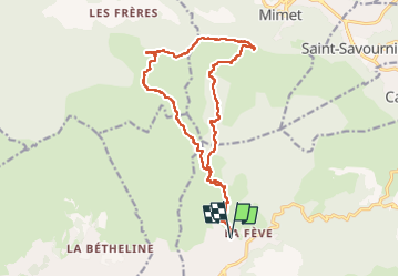
Tocht Stappen van 18 km beschikbaar op Provence-Alpes-Côte d'Azur, Bouches-du-Rhône, Allauch. Deze tocht wordt voorgesteld door Christiancordin.
Beschrijving
Départ du Quartier de Mordeau, vallon du Pilon du Roi, puits de Besson, Pilon du Roi, col Ste Anne, montagne du Bau Trauqua, source, jas de Mimet.
Plaatsbepaling
Land:
France
Regio :
Provence-Alpes-Côte d'Azur
Departement/Provincie :
Bouches-du-Rhône
Gemeente :
Allauch
Locatie:
Unknown
Vertrek:(Dec)
Vertrek:(UTM)
701677 ; 4804195 (31T) N.
Opmerkingen
Wandeltochten in de omgeving
![Tocht Stappen Allauch - SityTrail - le Pilon - Photo](https://media.geolcdn.com/t/375/260/f70c47ce-637e-4170-ac86-2a2a395feaa2.jpg&format=jpg&maxdim=2)
![Stappen Stappen](https://static1.geolcdn.com/sitytour/trail-icons/101.png)
SityTrail - le Pilon
Stappen
Medium
(1)
Allauch,
Provence-Alpes-Côte d'Azur,
Bouches-du-Rhône,
France
![](/images/other/stat-length.png)
13,7 km | 20 km-effort
6h 0min
![](https://static1.geolcdn.com/siteimages/upload/files/16400158638029165_repeat_loop_refresh_sync_direction_icon.png)
Ja
![Tocht Stappen Allauch - Le tour des Grands Ubacs au départ de Pichauris - Photo](https://media.geolcdn.com/t/375/260/21675de2-6304-4cb6-a0f7-b5d15f62bb3e.jpg&format=jpg&maxdim=2)
![Stappen Stappen](https://static1.geolcdn.com/sitytour/trail-icons/101.png)
Le tour des Grands Ubacs au départ de Pichauris
Stappen
Gemakkelijk
(1)
Allauch,
Provence-Alpes-Côte d'Azur,
Bouches-du-Rhône,
France
![](/images/other/stat-length.png)
13,3 km | 20 km-effort
4h 25min
![](https://static1.geolcdn.com/siteimages/upload/files/16400158638029165_repeat_loop_refresh_sync_direction_icon.png)
Ja
![Tocht Stappen Allauch - Domaine de Pichauris - Allauch - Photo](https://media.geolcdn.com/t/375/260/ext.jpg?maxdim=2&url=https%3A%2F%2Fservices.sitytrail.com%2FGeolivesWS%2FDownloadMedia.ashx%3FTrailID%3D103813%26Media%3D6587_1.jpg)
![Stappen Stappen](https://static1.geolcdn.com/sitytour/trail-icons/101.png)
Domaine de Pichauris - Allauch
Stappen
Medium
(1)
Allauch,
Provence-Alpes-Côte d'Azur,
Bouches-du-Rhône,
France
![](/images/other/stat-length.png)
10,5 km | 15 km-effort
2h 30min
![](https://static1.geolcdn.com/siteimages/upload/files/16400158638029165_repeat_loop_refresh_sync_direction_icon.png)
Ja
![Tocht Stappen Allauch - le pic du Taoumé par Pichauris - Photo](https://media.geolcdn.com/t/375/260/6e9ae51a-41c8-431b-88f6-0e231e4db660.jpg&format=jpg&maxdim=2)
![Stappen Stappen](https://static1.geolcdn.com/sitytour/trail-icons/101.png)
le pic du Taoumé par Pichauris
Stappen
Gemakkelijk
Allauch,
Provence-Alpes-Côte d'Azur,
Bouches-du-Rhône,
France
![](/images/other/stat-length.png)
13,3 km | 20 km-effort
4h 32min
![](https://static1.geolcdn.com/siteimages/upload/files/16400158638029165_repeat_loop_refresh_sync_direction_icon.png)
Ja
![Tocht Mountainbike Allauch - les antennes du garlaban à modifier - Photo](https://media.geolcdn.com/t/375/260/b5861fec-07e7-4c16-8ca8-179e78ebdfae.jpg&format=jpg&maxdim=2)
![Mountainbike Mountainbike](https://static1.geolcdn.com/sitytour/trail-icons/202.png)
les antennes du garlaban à modifier
Mountainbike
Medium
Allauch,
Provence-Alpes-Côte d'Azur,
Bouches-du-Rhône,
France
![](/images/other/stat-length.png)
19,3 km | 28 km-effort
2h 8min
![](https://static1.geolcdn.com/siteimages/upload/files/16400158638029165_repeat_loop_refresh_sync_direction_icon.png)
Ja
![Tocht Mountainbike Allauch - les antennes du garlaban - Photo](https://media.geolcdn.com/t/375/260/b5861fec-07e7-4c16-8ca8-179e78ebdfae.jpg&format=jpg&maxdim=2)
![Mountainbike Mountainbike](https://static1.geolcdn.com/sitytour/trail-icons/202.png)
les antennes du garlaban
Mountainbike
Medium
Allauch,
Provence-Alpes-Côte d'Azur,
Bouches-du-Rhône,
France
![](/images/other/stat-length.png)
19,3 km | 28 km-effort
2h 8min
![](https://static1.geolcdn.com/siteimages/upload/files/16400158638029165_repeat_loop_refresh_sync_direction_icon.png)
Ja
![Tocht Mountainbike Allauch - de Pichauris au mont du Marseillais - Photo](https://media.geolcdn.com/t/375/260/ext.jpg?maxdim=2&url=https%3A%2F%2Fservices.sitytrail.com%2FGeolivesWS%2FDownloadMedia.ashx%3FTrailID%3D855696%26Media%3Dfix__20171101163219.jpg)
![Mountainbike Mountainbike](https://static1.geolcdn.com/sitytour/trail-icons/202.png)
de Pichauris au mont du Marseillais
Mountainbike
Medium
Allauch,
Provence-Alpes-Côte d'Azur,
Bouches-du-Rhône,
France
![](/images/other/stat-length.png)
14 km | 19,2 km-effort
2h 34min
![](https://static1.geolcdn.com/siteimages/upload/files/16400158638029165_repeat_loop_refresh_sync_direction_icon.png)
Ja
![Tocht Stappen Allauch - Pic du Taoumé - Photo](https://media.geolcdn.com/t/375/260/ext.jpg?maxdim=2&url=https%3A%2F%2Fservices.sitytrail.com%2FGeolivesWS%2FDownloadMedia.ashx%3FTrailID%3D359528%26Media%3Dfix__20141102145545.jpg)
![Stappen Stappen](https://static1.geolcdn.com/sitytour/trail-icons/101.png)
Pic du Taoumé
Stappen
Gemakkelijk
Allauch,
Provence-Alpes-Côte d'Azur,
Bouches-du-Rhône,
France
![](/images/other/stat-length.png)
9,2 km | 15,2 km-effort
5h 5min
![](https://static1.geolcdn.com/siteimages/upload/files/16400158638029165_repeat_loop_refresh_sync_direction_icon.png)
Ja
![Tocht Stappen Marseille - La Grande Etoile - Photo](https://media.geolcdn.com/t/375/260/ext.jpg?maxdim=2&url=https%3A%2F%2Fservices.sitytrail.com%2FGeolivesWS%2FDownloadMedia.ashx%3FTrailID%3D168949%26Media%3D20130106124039.jpeg)
![Stappen Stappen](https://static1.geolcdn.com/sitytour/trail-icons/101.png)
La Grande Etoile
Stappen
Medium
Marseille,
Provence-Alpes-Côte d'Azur,
Bouches-du-Rhône,
France
![](/images/other/stat-length.png)
15,4 km | 23 km-effort
4h 48min
![](https://static1.geolcdn.com/siteimages/upload/files/16400158638029165_repeat_loop_refresh_sync_direction_icon.png)
Ja