![](/images/other/stat-length.png)
![Tocht Te voet North Norfolk - Bacton Circular - Photo](https://media.geolcdn.com/t/1900/400/ext.pjpeg?maxdim=2&url=https%3A%2F%2Fstatic1.geolcdn.com%2Fsiteimages%2Fupload%2Ffiles%2F1545311037marcheuse_200dpi.jpg)
Bacton Circular
SityTrail - itinéraires balisés pédestres
Tous les sentiers balisés d’Europe GUIDE+
![Lengte](/images/other/stat-length.png)
Lengte
8,4 km
![Max. hoogte](https://static1.geolcdn.com/siteimages/upload/files/1508320355ic_sort_altitude_max_24dp.png)
Max. hoogte
30 m
![Positief hoogteverschil](https://static1.geolcdn.com/siteimages/upload/files/1508320355ic_sort_den_pos_24dp.png)
Positief hoogteverschil
62 m
![Km-Effort](/images/other/stat-length.png)
Km-Effort
9,2 km
![Min. hoogte](https://static1.geolcdn.com/siteimages/upload/files/1508320355ic_sort_altitude_min_24dp.png)
Min. hoogte
4 m
![Negatief hoogteverschil](https://static1.geolcdn.com/siteimages/upload/files/1508320355ic_sort_den_neg_24dp.png)
Negatief hoogteverschil
61 m
![Boucle](https://static1.geolcdn.com/siteimages/upload/files/16400158638029165_repeat_loop_refresh_sync_direction_icon.png)
Boucle
Neen
Markering
Datum van aanmaak :
2025-02-05 16:16:15.034
Laatste wijziging :
2025-02-05 16:16:15.034
![Te voet](https://static1.geolcdn.com/sitytour/trail-icons/100.png)
2h06
Moeilijkheid : Gemakkelijk
![Scan deze QR-code om de tocht te openen in de SityTrail-applicatie](https://capi.geolives.com/qq0zvz2zws4bq2lad0pu/sitytour/trails/4342061/qr.png?size=200)
Gratisgps-wandelapplicatie
Over ons
Tocht Te voet van 8,4 km beschikbaar op Engeland, Norfolk, North Norfolk. Deze tocht wordt voorgesteld door SityTrail - itinéraires balisés pédestres.
Beschrijving
Website: https://www.nationaltrail.co.uk/en_GB/short-routes/bacton-circular-walk-2/
Plaatsbepaling
Land:
United Kingdom
Regio :
Engeland
Departement/Provincie :
Norfolk
Gemeente :
North Norfolk
Locatie:
Unknown
Vertrek:(Dec)
Vertrek:(UTM)
397922 ; 5856330 (31U) N.
Opmerkingen
Wandeltochten in de omgeving
![Tocht Te voet North Norfolk - Sheringham Circular - Photo](https://media.geolcdn.com/t/375/260/a9edcb65-5663-4720-a358-566ab32be620.jpeg&format=jpg&maxdim=2)
![Te voet Te voet](https://static1.geolcdn.com/sitytour/trail-icons/100.png)
Sheringham Circular
Te voet
Gemakkelijk
North Norfolk,
Engeland,
Norfolk,
United Kingdom
![](/images/other/stat-length.png)
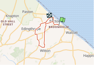
10,9 km | 13,2 km-effort
2h 59min
![](https://static1.geolcdn.com/siteimages/upload/files/16400158638029165_repeat_loop_refresh_sync_direction_icon.png)
Ja
![Tocht Te voet Broadland - Aylsham Circular - Photo](https://media.geolcdn.com/t/375/260/9eb6be60-e6f0-4a51-98a1-01905c7c1575.jpeg&format=jpg&maxdim=2)
![Te voet Te voet](https://static1.geolcdn.com/sitytour/trail-icons/100.png)
Aylsham Circular
Te voet
Gemakkelijk
Broadland,
Engeland,
Norfolk,
United Kingdom
![](/images/other/stat-length.png)
5,7 km | 6,4 km-effort
1h 27min
![](https://static1.geolcdn.com/siteimages/upload/files/16400158638029165_repeat_loop_refresh_sync_direction_icon.png)
Neen
![Tocht Te voet Broadland - Blickling Estate Green Route - Photo](https://media.geolcdn.com/t/375/260/69bf3c45-a9ee-4960-9950-5403b7420992.jpeg&format=jpg&maxdim=2)
![Te voet Te voet](https://static1.geolcdn.com/sitytour/trail-icons/100.png)
Blickling Estate Green Route
Te voet
Gemakkelijk
Broadland,
Engeland,
Norfolk,
United Kingdom
![](/images/other/stat-length.png)
3,8 km | 4,3 km-effort
58min
![](https://static1.geolcdn.com/siteimages/upload/files/16400158638029165_repeat_loop_refresh_sync_direction_icon.png)
Ja