![](/images/other/stat-length.png)
![Tocht Te voet Colchester - Colchester Orbital South A - Photo](https://media.geolcdn.com/t/1900/400/5dca1c1c-dfd7-4b1e-a72a-f4137907f80b.jpeg&format=pjpeg&maxdim=2)
Colchester Orbital South A
SityTrail - itinéraires balisés pédestres
Tous les sentiers balisés d’Europe GUIDE+
![Lengte](/images/other/stat-length.png)
![Max. hoogte](https://static1.geolcdn.com/siteimages/upload/files/1508320355ic_sort_altitude_max_24dp.png)
![Positief hoogteverschil](https://static1.geolcdn.com/siteimages/upload/files/1508320355ic_sort_den_pos_24dp.png)
![Km-Effort](/images/other/stat-length.png)
![Min. hoogte](https://static1.geolcdn.com/siteimages/upload/files/1508320355ic_sort_altitude_min_24dp.png)
![Negatief hoogteverschil](https://static1.geolcdn.com/siteimages/upload/files/1508320355ic_sort_den_neg_24dp.png)
![Boucle](https://static1.geolcdn.com/siteimages/upload/files/16400158638029165_repeat_loop_refresh_sync_direction_icon.png)
![Te voet](https://static1.geolcdn.com/sitytour/trail-icons/100.png)
1h39
Moeilijkheid : Gemakkelijk
![Scan deze QR-code om de tocht te openen in de SityTrail-applicatie](https://capi.geolives.com/qq0zvz2zws4bq2lad0pu/sitytour/trails/4341783/qr.png?size=200)
Gratisgps-wandelapplicatie
Over ons
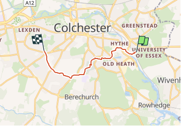
Tocht Te voet van 6,5 km beschikbaar op Engeland, Essex, Colchester. Deze tocht wordt voorgesteld door SityTrail - itinéraires balisés pédestres.
Beschrijving
Approximately 14-15 miles in length, the Colchester Orbital is a circular walk/cycle route around the periphery of the town, taking advantage of and connecting some of its loveliest green spaces and off-road pathway networks. The route follows existing public rights of way, linking with cycle paths wherever possible,
Website: https://www.walkcolchester.org.uk/the-colchester-orbital
Plaatsbepaling
Opmerkingen
Wandeltochten in de omgeving
![Tocht Te voet Colchester - Colchester Orbital West A - Photo](https://media.geolcdn.com/t/375/260/0d441f0f-2c66-4c1f-a1a0-359e23c3e00b.jpeg&format=jpg&maxdim=2)
![Te voet Te voet](https://static1.geolcdn.com/sitytour/trail-icons/100.png)
Te voet
![](/images/other/stat-length.png)
![](https://static1.geolcdn.com/siteimages/upload/files/16400158638029165_repeat_loop_refresh_sync_direction_icon.png)
![Tocht Te voet Colchester - Colchester Orbital West B - Photo](https://media.geolcdn.com/t/375/260/0d441f0f-2c66-4c1f-a1a0-359e23c3e00b.jpeg&format=jpg&maxdim=2)
![Te voet Te voet](https://static1.geolcdn.com/sitytour/trail-icons/100.png)
Te voet
![](/images/other/stat-length.png)
![](https://static1.geolcdn.com/siteimages/upload/files/16400158638029165_repeat_loop_refresh_sync_direction_icon.png)
![Tocht Te voet Colchester - Colchester Orbital East B - Photo](https://media.geolcdn.com/t/375/260/54359070-5ddc-4afa-aa08-947399d698ca.jpeg&format=jpg&maxdim=2)
![Te voet Te voet](https://static1.geolcdn.com/sitytour/trail-icons/100.png)
Te voet
![](/images/other/stat-length.png)
![](https://static1.geolcdn.com/siteimages/upload/files/16400158638029165_repeat_loop_refresh_sync_direction_icon.png)
![Tocht Te voet Colchester - Colchester Orbital East A - Photo](https://media.geolcdn.com/t/375/260/45872d54-7616-4d97-a9c5-762dc39d83f5.jpeg&format=jpg&maxdim=2)
![Te voet Te voet](https://static1.geolcdn.com/sitytour/trail-icons/100.png)
Te voet
![](/images/other/stat-length.png)
![](https://static1.geolcdn.com/siteimages/upload/files/16400158638029165_repeat_loop_refresh_sync_direction_icon.png)