![](/images/other/stat-length.png)
![Tocht Te voet Unknown - Spurlswood Walk - Photo](https://media.geolcdn.com/t/1900/400/1f8c7d52-4353-4429-ac05-96f3db193161.jpeg&format=pjpeg&maxdim=2)
Spurlswood Walk
SityTrail - itinéraires balisés pédestres
Tous les sentiers balisés d’Europe GUIDE+
![Lengte](/images/other/stat-length.png)
Lengte
6,4 km
![Max. hoogte](https://static1.geolcdn.com/siteimages/upload/files/1508320355ic_sort_altitude_max_24dp.png)
Max. hoogte
280 m
![Positief hoogteverschil](https://static1.geolcdn.com/siteimages/upload/files/1508320355ic_sort_den_pos_24dp.png)
Positief hoogteverschil
105 m
![Km-Effort](/images/other/stat-length.png)
Km-Effort
7,8 km
![Min. hoogte](https://static1.geolcdn.com/siteimages/upload/files/1508320355ic_sort_altitude_min_24dp.png)
Min. hoogte
187 m
![Negatief hoogteverschil](https://static1.geolcdn.com/siteimages/upload/files/1508320355ic_sort_den_neg_24dp.png)
Negatief hoogteverschil
105 m
![Boucle](https://static1.geolcdn.com/siteimages/upload/files/16400158638029165_repeat_loop_refresh_sync_direction_icon.png)
Boucle
Ja
Markering
Datum van aanmaak :
2025-02-05 11:08:00.375
Laatste wijziging :
2025-02-05 11:08:00.375
![Te voet](https://static1.geolcdn.com/sitytour/trail-icons/100.png)
1h45
Moeilijkheid : Gemakkelijk
![Scan deze QR-code om de tocht te openen in de SityTrail-applicatie](https://capi.geolives.com/qq0zvz2zws4bq2lad0pu/sitytour/trails/4341267/qr.png?size=200)
Gratisgps-wandelapplicatie
Over ons
Tocht Te voet van 6,4 km beschikbaar op Engeland, County Durham. Deze tocht wordt voorgesteld door SityTrail - itinéraires balisés pédestres.
Beschrijving
Tocht aangemaakt door Forestry England.
North section of route needs checking against waymarking
Plaatsbepaling
Land:
United Kingdom
Regio :
Engeland
Departement/Provincie :
County Durham
Gemeente :
Unknown
Locatie:
Unknown
Vertrek:(Dec)
Vertrek:(UTM)
570942 ; 6057823 (30U) N.
Opmerkingen
Wandeltochten in de omgeving
![Tocht Te voet - Bedburn Valley Walk - Photo](https://media.geolcdn.com/t/375/260/0a41f570-2a9a-41da-9fe2-805b8113c01c.jpeg&format=jpg&maxdim=2)
![Te voet Te voet](https://static1.geolcdn.com/sitytour/trail-icons/100.png)
Bedburn Valley Walk
Te voet
Gemakkelijk
,
Engeland,
County Durham,
United Kingdom
![](/images/other/stat-length.png)
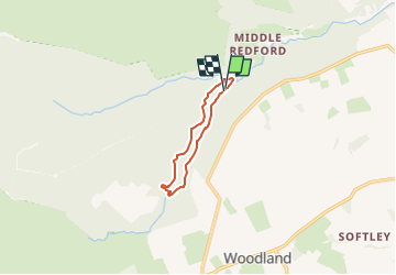
4,8 km | 6,3 km-effort
1h 25min
![](https://static1.geolcdn.com/siteimages/upload/files/16400158638029165_repeat_loop_refresh_sync_direction_icon.png)
Ja
![Tocht Te voet - Three Becks Walk - Photo](https://media.geolcdn.com/t/375/260/340d9e1f-928a-48a2-8af8-1fc0e9529e41.jpeg&format=jpg&maxdim=2)
![Te voet Te voet](https://static1.geolcdn.com/sitytour/trail-icons/100.png)
Three Becks Walk
Te voet
Gemakkelijk
,
Engeland,
County Durham,
United Kingdom
![](/images/other/stat-length.png)
7,8 km | 10,7 km-effort
2h 26min
![](https://static1.geolcdn.com/siteimages/upload/files/16400158638029165_repeat_loop_refresh_sync_direction_icon.png)
Ja