Bath Skyline
SityTrail - itinéraires balisés pédestres
Tous les sentiers balisés d’Europe GUIDE+
Lengte
9,3 km
Max. hoogte
191 m
Positief hoogteverschil
202 m
Km-Effort
12 km
Min. hoogte
55 m
Negatief hoogteverschil
203 m
Boucle
Ja
Markering
Datum van aanmaak :
2025-02-05 11:01:03.676
Laatste wijziging :
2025-02-05 11:01:03.676
2h43
Moeilijkheid : Gemakkelijk
Gratisgps-wandelapplicatie
Over ons
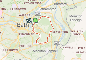
Tocht Te voet van 9,3 km beschikbaar op Engeland, Bath and North East Somerset. Deze tocht wordt voorgesteld door SityTrail - itinéraires balisés pédestres.
Beschrijving
Explore the fascinating area around Bath along the six miles of footpaths that make up the National Trust's Bath Skyline walk.
Website: https://www.nationaltrust.org.uk/bath-skyline/
Plaatsbepaling
Land:
United Kingdom
Regio :
Engeland
Departement/Provincie :
Bath and North East Somerset
Gemeente :
Unknown
Locatie:
Unknown
Vertrek:(Dec)
Vertrek:(UTM)
545517 ; 5692343 (30U) N.
Opmerkingen
Wandeltochten in de omgeving
j9 Bath
Stappen
Moeilijk
,
Engeland,
Bath and North East Somerset,
United Kingdom
12,5 km | 14,6 km-effort
3h 1min
Neen
j8 Bradford on avon
Stappen
Medium
,
Engeland,
Bath and North East Somerset,
United Kingdom
9,9 km | 11,4 km-effort
2h 35min
Neen
j7 Bath Skyline, vergers, cimetière
Stappen
Moeilijk
,
Engeland,
Bath and North East Somerset,
United Kingdom
10,7 km | 14,1 km-effort
3h 11min
Ja