Tocht Te voet Hinckley and Bosworth - Footpath T53 - Photo

Tous les sentiers balisés d’Europe GUIDE+

© OpenStreetMap contributors
Lengte
Lengte
3 km
Max. hoogte
Max. hoogte
112 m
Positief hoogteverschil
18 m
Km-Effort
Km-Effort  
3,3 km
Min. hoogte
Min. hoogte
95 m
Negatief hoogteverschil
18 m
Boucle
Boucle
Neen
Markering
Markering
Datum van aanmaak :
2025-02-05 10:41:57.93
Laatste wijziging :
2025-02-05 10:41:57.93

(0 Bericht)

Te voet
Te voet
44m
Moeilijkheid : Gemakkelijk

Scan deze QR-code om de tocht te openen in de SityTrail-applicatie

Gratisgps-wandelapplicatie

Logo SityTrail SityTrail

IGN / Geografische instituten

SityTrail uit de App Store downloaden SityTrail uit Google Play downloaden

Logo SityTrail SityTrail World

De wereld gaat voor u open

SityTrail uit de App Store downloaden SityTrail uit Google Play downloaden SityTrail op Huawei AppGallery downloaden

Over ons

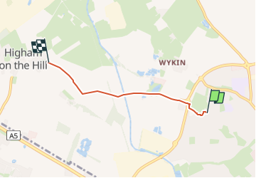
Tocht Te voet van 3 km beschikbaar op Engeland, Leicestershire, Hinckley and Bosworth. Deze tocht wordt voorgesteld door SityTrail - itinéraires balisés pédestres.

Beschrijving

From Hinckley Lane, Higham on the Hill to Outlands Drive, Hinckley.

Hoogteprofiel

Plaatsbepaling

Land:
United Kingdom
Regio :
Engeland
Departement/Provincie :
Leicestershire
Gemeente :
Hinckley and Bosworth
Locatie:
Unknown
Vertrek:(UTM)
608901 ; 5823185 (30U) N.

Wandeltochten in de omgeving

Tocht Te voet Hinckley and Bosworth - Footpath T54 - Photo
Te voet
GUIDE+

Te voet

Gemakkelijk
Hinckley and Bosworth, Engeland, Leicestershire, United Kingdom
6 km | 6,4 km-effort
1h 26min
Neen


Sluiten
Mijn abonnementen