Tocht Te voet Hinckley and Bosworth - Footpath T54 - Photo

Tous les sentiers balisés d’Europe GUIDE+

© OpenStreetMap contributors
Lengte
Lengte
6 km
Max. hoogte
Max. hoogte
100 m
Positief hoogteverschil
27 m
Km-Effort
Km-Effort  
6,4 km
Min. hoogte
Min. hoogte
92 m
Negatief hoogteverschil
27 m
Boucle
Boucle
Neen
Markering
Markering
Datum van aanmaak :
2025-02-05 10:40:45.924
Laatste wijziging :
2025-02-05 10:40:45.924

(0 Bericht)

Te voet
Te voet
1h26
Moeilijkheid : Gemakkelijk

Scan deze QR-code om de tocht te openen in de SityTrail-applicatie

Gratisgps-wandelapplicatie

Logo SityTrail SityTrail

IGN / Geografische instituten

SityTrail uit de App Store downloaden SityTrail uit Google Play downloaden

Logo SityTrail SityTrail World

De wereld gaat voor u open

SityTrail uit de App Store downloaden SityTrail uit Google Play downloaden SityTrail op Huawei AppGallery downloaden

Over ons

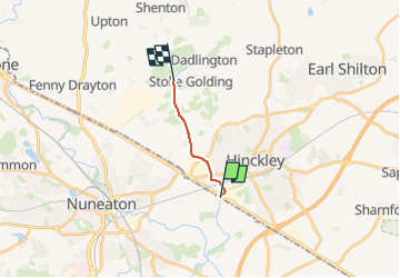
Tocht Te voet van 6 km beschikbaar op Engeland, Leicestershire, Hinckley and Bosworth. Deze tocht wordt voorgesteld door SityTrail - itinéraires balisés pédestres.

Beschrijving

From Stoke Golding Wharf, along western bank of canal to Lime Kiln Bridge at Watling Street, Hinckley, and to the County Boundary with Warwickshire

Hoogteprofiel

Foto's

Plaatsbepaling

Land:
United Kingdom
Regio :
Engeland
Departement/Provincie :
Leicestershire
Gemeente :
Hinckley and Bosworth
Locatie:
Unknown
Vertrek:(UTM)
608883 ; 5820866 (30U) N.

Wandeltochten in de omgeving

Tocht Te voet Hinckley and Bosworth - Footpath T53 - Photo
Te voet
GUIDE+

Te voet

Gemakkelijk
Hinckley and Bosworth, Engeland, Leicestershire, United Kingdom
3 km | 3,3 km-effort
44min
Neen


Sluiten
Mijn abonnementen