Tocht Te voet Rushcliffe - Rushcliffe Country Park 10km Course - Photo

Rushcliffe Country Park 10km Course

Tous les sentiers balisés d’Europe GUIDE+

© OpenStreetMap contributors
Lengte
Lengte
9,9 km
Max. hoogte
Max. hoogte
48 m
Positief hoogteverschil
66 m
Km-Effort
Km-Effort  
10,8 km
Min. hoogte
Min. hoogte
33 m
Negatief hoogteverschil
66 m
Boucle
Boucle
Ja
Markering
Markering
Datum van aanmaak :
2025-02-05 08:59:41.491
Laatste wijziging :
2025-02-05 08:59:41.491

(0 Bericht)

Te voet
Te voet
2h27
Moeilijkheid : Gemakkelijk

Scan deze QR-code om de tocht te openen in de SityTrail-applicatie

Gratisgps-wandelapplicatie

Logo SityTrail SityTrail

IGN / Geografische instituten

SityTrail uit de App Store downloaden SityTrail uit Google Play downloaden

Logo SityTrail SityTrail World

De wereld gaat voor u open

SityTrail uit de App Store downloaden SityTrail uit Google Play downloaden SityTrail op Huawei AppGallery downloaden

Over ons

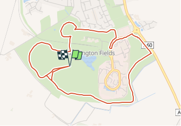
Tocht Te voet van 9,9 km beschikbaar op Engeland, Nottinghamshire, Rushcliffe. Deze tocht wordt voorgesteld door SityTrail - itinéraires balisés pédestres.

Beschrijving

This is a 10km running course - the majority of which is ran two times - have not yet found the 3km milepost (kilometerpost?) or the start/finish points.

Foto's

Plaatsbepaling

Land:
United Kingdom
Regio :
Engeland
Departement/Provincie :
Nottinghamshire
Gemeente :
Rushcliffe
Locatie:
Unknown
Vertrek:(UTM)
624394 ; 5860794 (30U) N.

Wandeltochten in de omgeving

Tocht Te voet Rushcliffe - Yellow - Photo
Te voet
GUIDE+

Te voet

Gemakkelijk
Rushcliffe, Engeland, Nottinghamshire, United Kingdom
4 km | 4,4 km-effort
59min
Ja
Tocht Te voet Rushcliffe - Gotham Heritage Trail - Photo
Te voet
GUIDE+

Te voet

Gemakkelijk
Rushcliffe, Engeland, Nottinghamshire, United Kingdom
4,3 km | 5,3 km-effort
1h 11min
Neen


Sluiten
Mijn abonnementen