


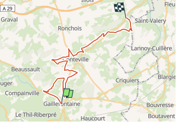

10,9 km | 11,6 km-effort


Gebruiker


Gratisgps-wandelapplicatie
 SityTrail
IGN / Geografische instituten
SityTrail World
De wereld gaat voor u open
Tocht 4x4 van 28 km beschikbaar op Normandië, Seine-Maritime, Gaillefontaine. Deze tocht wordt voorgesteld door club de la bresle.
Paard

Mountainbike

Stappen
Te voet

Fiets

Te voet
Te voet
Te voet
Te voet