Tocht Stappen La Chapelle-en-Valgaudémar - Valgaudemar en famille: jour 5 La Chapelle aux lacs Pétarel - Photo

Valgaudemar en famille: jour 5 La Chapelle aux lacs Pétarel

 MathieuBourgois
MathieuBourgois

Gebruiker

© OpenStreetMap contributors
Lengte
Lengte
7,3 km
Max. hoogte
Max. hoogte
2108 m
Positief hoogteverschil
1046 m
Km-Effort
Km-Effort  
17,9 km
Min. hoogte
Min. hoogte
1093 m
Negatief hoogteverschil
36 m
Boucle
Boucle
Neen
Datum van aanmaak :
2025-01-16 10:48:52.014
Laatste wijziging :
2025-01-16 10:49:40.988

(0 Bericht)

Stappen
Stappen
4h03
Moeilijkheid : Moeilijk

Scan deze QR-code om de tocht te openen in de SityTrail-applicatie

Gratisgps-wandelapplicatie

Logo SityTrail SityTrail

IGN / Geografische instituten

SityTrail uit de App Store downloaden SityTrail uit Google Play downloaden

Logo SityTrail SityTrail World

De wereld gaat voor u open

SityTrail uit de App Store downloaden SityTrail uit Google Play downloaden SityTrail op Huawei AppGallery downloaden

Over ons

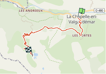
Tocht Stappen van 7,3 km beschikbaar op Provence-Alpes-Côte d'Azur, Hautes-Alpes, La Chapelle-en-Valgaudémar. Deze tocht wordt voorgesteld door MathieuBourgois.

Beschrijving

7.3km
1050D
36D-

Hoogteprofiel

Plaatsbepaling

Land:
France
Regio :
Provence-Alpes-Côte d'Azur
Departement/Provincie :
Hautes-Alpes
Gemeente :
La Chapelle-en-Valgaudémar
Locatie:
Unknown
Vertrek:(UTM)
278100 ; 4966512 (32T) N.

Wandeltochten in de omgeving

Tocht Stappen La Chapelle-en-Valgaudémar - circuit de la cabane de l'aup .08-06-14 - Photo
Stappen
Dervalmarc

Stappen

Heel gemakkelijk
(1)
La Chapelle-en-Valgaudémar, Provence-Alpes-Côte d'Azur, Hautes-Alpes, France
8,8 km | 13,6 km-effort
2h 37min
Ja
Tocht Stappen La Chapelle-en-Valgaudémar - Tour du Vieux Chaillol 2/5 - Du Gîte Le Casset au Refuge de Vallonpierre - Photo
Stappen
tracegps

Stappen

Medium
(1)
La Chapelle-en-Valgaudémar, Provence-Alpes-Côte d'Azur, Hautes-Alpes, France
11,8 km | 24 km-effort
4h 30min
Neen
Tocht Stappen Villar-Loubière - Pic Turbat - Photo
Stappen
GUIDE
Marco05

Stappen

Zeer moeilijk
Villar-Loubière, Provence-Alpes-Côte d'Azur, Hautes-Alpes, France
19,8 km | 46 km-effort
10h 26min
Ja
Tocht Stappen La Chapelle-en-Valgaudémar - Lacs de Pétarel-Col de la Béranne - Photo
Stappen
GUIDE
Marco05

Stappen

Medium
La Chapelle-en-Valgaudémar, Provence-Alpes-Côte d'Azur, Hautes-Alpes, France
11,1 km | 23 km-effort
7h 0min
Ja
Tocht Stappen La Chapelle-en-Valgaudémar - Pas de l'Olan - Photo
Stappen
GUIDE
Marco05

Stappen

Zeer moeilijk
La Chapelle-en-Valgaudémar, Provence-Alpes-Côte d'Azur, Hautes-Alpes, France
12,6 km | 34 km-effort
7h 37min
Ja
Tocht Stappen La Chapelle-en-Valgaudémar - Valgaudemar - La Chapelle (les Portes) forêt - 4.3km 285m 1h35 - 2018 07 05 - public - Photo
Stappen
GUIDE
Orcal37

Stappen

Gemakkelijk
La Chapelle-en-Valgaudémar, Provence-Alpes-Côte d'Azur, Hautes-Alpes, France
4,3 km | 8,1 km-effort
1h 40min
Ja
Tocht Stappen La Chapelle-en-Valgaudémar - Valgaudemar - La Chapelle Vallon de la Navette - 10.9km 420m 3h25 - 2018 06 30 - public - Photo
Stappen
GUIDE
Orcal37

Stappen

Medium
La Chapelle-en-Valgaudémar, Provence-Alpes-Côte d'Azur, Hautes-Alpes, France
10,9 km | 16,4 km-effort
4h 30min
Ja
Tocht Stappen La Chapelle-en-Valgaudémar - Valgaudemar - La Chapelle Vallée de la Séveraisse Refuge du Clot - 15.9km 450m 4h35 - 2018 07 01 - public - Photo
Stappen
GUIDE
Orcal37

Stappen

Medium
La Chapelle-en-Valgaudémar, Provence-Alpes-Côte d'Azur, Hautes-Alpes, France
15,9 km | 22 km-effort
5h 55min
Ja
Tocht Stappen La Chapelle-en-Valgaudémar - le Chapeau  - Photo
Stappen
GUIDE
orsel

Stappen

Moeilijk
La Chapelle-en-Valgaudémar, Provence-Alpes-Côte d'Azur, Hautes-Alpes, France
14,6 km | 31 km-effort
7h 37min
Ja


Sluiten
Mijn abonnementen