Tocht Stappen Léran - tour lac Montbel  - Photo

tour lac Montbel

 Mamilaure
Mamilaure

Gebruiker

© OpenStreetMap contributors
Lengte
Lengte
16,6 km
Max. hoogte
Max. hoogte
422 m
Positief hoogteverschil
199 m
Km-Effort
Km-Effort  
19,2 km
Min. hoogte
Min. hoogte
394 m
Negatief hoogteverschil
201 m
Boucle
Boucle
Ja
Datum van aanmaak :
2025-01-14 08:53:13.233
Laatste wijziging :
2025-01-23 08:37:59.773

(0 Bericht)

Stappen
Stappen
4h19
Moeilijkheid : Medium

Scan deze QR-code om de tocht te openen in de SityTrail-applicatie

Gratisgps-wandelapplicatie

Logo SityTrail SityTrail

IGN / Geografische instituten

SityTrail uit de App Store downloaden SityTrail uit Google Play downloaden

Logo SityTrail SityTrail World

De wereld gaat voor u open

SityTrail uit de App Store downloaden SityTrail uit Google Play downloaden SityTrail op Huawei AppGallery downloaden

Over ons

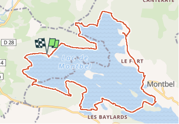
Tocht Stappen van 16,6 km beschikbaar op Occitanië, Ariège, Léran. Deze tocht wordt voorgesteld door Mamilaure.

Beschrijving

Se garer au parking de la base de loisirs de Leran près du camping pour une belle rando
Pose Déjeuner possible à la plage Montbel où il y a des tables
Attention prendre de bonnes chaussures et bâtons car passages boueux peuvent être glissants

Hoogteprofiel

Foto's

Plaatsbepaling

Land:
France
Regio :
Occitanië
Departement/Provincie :
Ariège
Gemeente :
Léran
Locatie:
Unknown
Vertrek:(UTM)
413396 ; 4759511 (31T) N.

Wandeltochten in de omgeving

Tocht Stappen Montbel - Lac de Montbel - Photo
Stappen
tracegps

Stappen

Medium
(2)
Montbel, Occitanië, Ariège, France
15,8 km | 18,4 km-effort
3h 19min
Ja
Tocht Mountainbike Léran - Lac de Montbel - Chalabre - Photo
Mountainbike
tracegps

Mountainbike

Medium
(1)
Léran, Occitanië, Ariège, France
25 km | 30 km-effort
3h 0min
Ja
Tocht Stappen Montbel - 1/2  - Photo
Stappen
gogo1965

Stappen

Gemakkelijk
Montbel, Occitanië, Ariège, France
48 km | 55 km-effort
2h 10min
Neen
Tocht Te voet Montbel - Tour du Lac de Montbel - Photo
Te voet
GUIDE+

Te voet

Gemakkelijk
Montbel, Occitanië, Ariège, France
15,3 km | 17,9 km-effort
4h 4min
Ja
Tocht Stappen Montbel - Barage lac de Monbel - Photo
Stappen
gogo1965

Stappen

Gemakkelijk
Montbel, Occitanië, Ariège, France
5,8 km | 6,9 km-effort
3h 5min
Neen
Tocht Kanoën - kajakken Belloc - Canoë sur le Touyre avec Mica et PPCAH - Photo
Kanoën - kajakken
jopost

Kanoën - kajakken

Medium
Belloc, Occitanië, Ariège, France
6,6 km | 7,7 km-effort
2h 25min
Neen
Tocht Mountainbike Sainte-Colombe-sur-l'Hers - Ste Colombe-sur-l'Hers Léran Camon - Photo
Mountainbike
jopost

Mountainbike

Moeilijk
Sainte-Colombe-sur-l'Hers, Occitanië, Aude, France
16,2 km | 19,6 km-effort
1h 25min
Neen
Tocht Mountainbike Camon - voie verte Camon Ste Colombe sur l'Hers - Photo
Mountainbike
jopost

Mountainbike

Medium
(1)
Camon, Occitanië, Ariège, France
13,3 km | 15,8 km-effort
1h 7min
Neen
Tocht Paard La Bastide-sur-l'Hers - La Bastide-sur-l'Hers - Roquefixade - Photo
Paard
tracegps

Paard

Zeer moeilijk
La Bastide-sur-l'Hers, Occitanië, Ariège, France
22 km | 34 km-effort
2h 30min
Neen


Sluiten
Mijn abonnementen