![](/images/other/stat-length.png)
![Tocht Andere activiteiten Marly - 510/Marly Grand-Pré/Pérolles-San Marco-Motta/S - Photo](https://media.geolcdn.com/t/1900/400/ext.pjpeg?maxdim=2&url=https%3A%2F%2Fstatic1.geolcdn.com%2Fsiteimages%2Fupload%2Ffiles%2F1545311037marcheuse_200dpi.jpg)
510/Marly Grand-Pré/Pérolles-San Marco-Motta/S
nordicmarly
Gebruiker
![Lengte](/images/other/stat-length.png)
Lengte
7,9 km
![Max. hoogte](https://static1.geolcdn.com/siteimages/upload/files/1508320355ic_sort_altitude_max_24dp.png)
Max. hoogte
644 m
![Positief hoogteverschil](https://static1.geolcdn.com/siteimages/upload/files/1508320355ic_sort_den_pos_24dp.png)
Positief hoogteverschil
242 m
![Km-Effort](/images/other/stat-length.png)
Km-Effort
11,1 km
![Min. hoogte](https://static1.geolcdn.com/siteimages/upload/files/1508320355ic_sort_altitude_min_24dp.png)
Min. hoogte
535 m
![Negatief hoogteverschil](https://static1.geolcdn.com/siteimages/upload/files/1508320355ic_sort_den_neg_24dp.png)
Negatief hoogteverschil
241 m
![Boucle](https://static1.geolcdn.com/siteimages/upload/files/16400158638029165_repeat_loop_refresh_sync_direction_icon.png)
Boucle
Ja
Datum van aanmaak :
2014-12-10 00:00:00.0
Laatste wijziging :
2014-12-10 00:00:00.0
![Andere activiteiten](https://static1.geolcdn.com/sitytour/trail-icons/900.png)
--
Moeilijkheid : Onbekend
![Scan deze QR-code om de tocht te openen in de SityTrail-applicatie](https://capi.geolives.com/qq0zvz2zws4bq2lad0pu/sitytour/trails/43177/qr.png?size=200)
Gratisgps-wandelapplicatie
Over ons
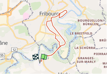
Tocht Andere activiteiten van 7,9 km beschikbaar op Fribourg/Freiburg, District de la Sarine, Marly. Deze tocht wordt voorgesteld door nordicmarly.
Beschrijving
Pont de Pérolles
Boulevard Pérolles
Escliers San Marco
Route-Neuve
Re de la Sarine
Chemin de la Motta
Route de la Neuveville
Route-Neuve
Escaliers San Marco
Rue de Locarno
Route de Arsenaux
Route Gockel
Chemin des Verdiers
Pont de Pérolles
Plaatsbepaling
Land:
Switzerland
Regio :
Fribourg/Freiburg
Departement/Provincie :
District de la Sarine
Gemeente :
Marly
Locatie:
Unknown
Vertrek:(Dec)
Vertrek:(UTM)
358472 ; 5182743 (32T) N.
Opmerkingen
Wandeltochten in de omgeving
![Tocht Te voet Villars-sur-Glâne - Tour des trois rivières - Photo](https://media.geolcdn.com/t/375/260/50fb974f-7178-4c1e-8fa3-33696ba9387d.jpeg&format=jpg&maxdim=2)
![Te voet Te voet](https://static1.geolcdn.com/sitytour/trail-icons/100.png)
Tour des trois rivières
Te voet
Gemakkelijk
Villars-sur-Glâne,
Fribourg/Freiburg,
District de la Sarine,
Switzerland
![](/images/other/stat-length.png)
5,1 km | 7,1 km-effort
1h 36min
![](https://static1.geolcdn.com/siteimages/upload/files/16400158638029165_repeat_loop_refresh_sync_direction_icon.png)
Neen
![Tocht Te voet Hauterive (FR) - Circuit Hauterive - Photo](https://media.geolcdn.com/t/375/260/0d2a055c-cfc9-4111-95d9-78b65bbb9d7b.jpeg&format=jpg&maxdim=2)
![Te voet Te voet](https://static1.geolcdn.com/sitytour/trail-icons/100.png)
Circuit Hauterive
Te voet
Gemakkelijk
Hauterive (FR),
Fribourg/Freiburg,
District de la Sarine,
Switzerland
![](/images/other/stat-length.png)
5 km | 6,7 km-effort
1h 31min
![](https://static1.geolcdn.com/siteimages/upload/files/16400158638029165_repeat_loop_refresh_sync_direction_icon.png)
Neen
![Tocht Te voet Hauterive (FR) - Hauterive - La Tuffière - Photo](https://media.geolcdn.com/t/375/260/0d2a055c-cfc9-4111-95d9-78b65bbb9d7b.jpeg&format=jpg&maxdim=2)
![Te voet Te voet](https://static1.geolcdn.com/sitytour/trail-icons/100.png)
Hauterive - La Tuffière
Te voet
Gemakkelijk
Hauterive (FR),
Fribourg/Freiburg,
District de la Sarine,
Switzerland
![](/images/other/stat-length.png)
5 km | 6,6 km-effort
1h 30min
![](https://static1.geolcdn.com/siteimages/upload/files/16400158638029165_repeat_loop_refresh_sync_direction_icon.png)
Neen
![Tocht Te voet Matran - Matran - Noréaz - Photo](https://media.geolcdn.com/t/375/260/7a2244db-87fb-4c17-aec0-e64a7984f7bf.jpeg&format=jpg&maxdim=2)
![Te voet Te voet](https://static1.geolcdn.com/sitytour/trail-icons/100.png)
Matran - Noréaz
Te voet
Gemakkelijk
Matran,
Fribourg/Freiburg,
District de la Sarine,
Switzerland
![](/images/other/stat-length.png)
5,9 km | 7,2 km-effort
1h 38min
![](https://static1.geolcdn.com/siteimages/upload/files/16400158638029165_repeat_loop_refresh_sync_direction_icon.png)
Neen
![Tocht Te voet Hauterive (FR) - Circuit de La Tuffière - Photo](https://media.geolcdn.com/t/375/260/0d2a055c-cfc9-4111-95d9-78b65bbb9d7b.jpeg&format=jpg&maxdim=2)
![Te voet Te voet](https://static1.geolcdn.com/sitytour/trail-icons/100.png)
Circuit de La Tuffière
Te voet
Gemakkelijk
Hauterive (FR),
Fribourg/Freiburg,
District de la Sarine,
Switzerland
![](/images/other/stat-length.png)
6,2 km | 8,2 km-effort
1h 52min
![](https://static1.geolcdn.com/siteimages/upload/files/16400158638029165_repeat_loop_refresh_sync_direction_icon.png)
Neen
![Tocht Te voet Hauterive (FR) - Grangeneuve - La Tuffière - Photo](https://media.geolcdn.com/t/375/260/a63f5649-2efe-45fa-bfef-a4d56ef9f525.jpeg&format=jpg&maxdim=2)
![Te voet Te voet](https://static1.geolcdn.com/sitytour/trail-icons/100.png)
Grangeneuve - La Tuffière
Te voet
Gemakkelijk
Hauterive (FR),
Fribourg/Freiburg,
District de la Sarine,
Switzerland
![](/images/other/stat-length.png)
5 km | 6,6 km-effort
1h 29min
![](https://static1.geolcdn.com/siteimages/upload/files/16400158638029165_repeat_loop_refresh_sync_direction_icon.png)
Neen
![Tocht Te voet Fribourg - Freiburg - Bourguillon - Schürmatt - Photo](https://media.geolcdn.com/t/375/260/c072d18f-e4ff-49d2-980f-d857947059bb.jpeg&format=jpg&maxdim=2)
![Te voet Te voet](https://static1.geolcdn.com/sitytour/trail-icons/100.png)
Bourguillon - Schürmatt
Te voet
Gemakkelijk
Fribourg - Freiburg,
Fribourg/Freiburg,
District de la Sarine,
Switzerland
![](/images/other/stat-length.png)
3,9 km | 5,5 km-effort
1h 14min
![](https://static1.geolcdn.com/siteimages/upload/files/16400158638029165_repeat_loop_refresh_sync_direction_icon.png)
Neen
![Tocht Te voet Fribourg - Freiburg - Freiburg - Fribourg (Jura) - Photo](https://media.geolcdn.com/t/375/260/bd747e02-b2c4-4e8d-9274-ea5285c3be0a.jpeg&format=jpg&maxdim=2)
![Te voet Te voet](https://static1.geolcdn.com/sitytour/trail-icons/100.png)
Freiburg - Fribourg (Jura)
Te voet
Gemakkelijk
Fribourg - Freiburg,
Fribourg/Freiburg,
District de la Sarine,
Switzerland
![](/images/other/stat-length.png)
3,8 km | 5,5 km-effort
1h 15min
![](https://static1.geolcdn.com/siteimages/upload/files/16400158638029165_repeat_loop_refresh_sync_direction_icon.png)
Neen
![Tocht Te voet Fribourg - Freiburg - Freiburg / Fribourg Balm / La Palme - Maggenberg - Photo](https://media.geolcdn.com/t/375/260/7a71c5bd-8e93-4c9f-9085-6acad23f2d78.jpeg&format=jpg&maxdim=2)
![Te voet Te voet](https://static1.geolcdn.com/sitytour/trail-icons/100.png)
Freiburg / Fribourg Balm / La Palme - Maggenberg
Te voet
Gemakkelijk
Fribourg - Freiburg,
Fribourg/Freiburg,
District de la Sarine,
Switzerland
![](/images/other/stat-length.png)
4,5 km | 7 km-effort
1h 35min
![](https://static1.geolcdn.com/siteimages/upload/files/16400158638029165_repeat_loop_refresh_sync_direction_icon.png)
Neen