Tocht Stappen Villaines-la-Gonais - le brame des cerfs - Photo
 darkpapa
darkpapa

Gebruiker

© OpenStreetMap contributors
Lengte
Lengte
9,1 km
Max. hoogte
Max. hoogte
127 m
Positief hoogteverschil
151 m
Km-Effort
Km-Effort  
11,1 km
Min. hoogte
Min. hoogte
82 m
Negatief hoogteverschil
151 m
Boucle
Boucle
Ja
Datum van aanmaak :
2025-01-10 16:09:40.257
Laatste wijziging :
2025-01-14 19:15:37.478

(0 Bericht)

Stappen
Stappen
2h30
Moeilijkheid : Gemakkelijk

Scan deze QR-code om de tocht te openen in de SityTrail-applicatie

Gratisgps-wandelapplicatie

Logo SityTrail SityTrail

IGN / Geografische instituten

SityTrail uit de App Store downloaden SityTrail uit Google Play downloaden

Logo SityTrail SityTrail World

De wereld gaat voor u open

SityTrail uit de App Store downloaden SityTrail uit Google Play downloaden SityTrail op Huawei AppGallery downloaden

Over ons

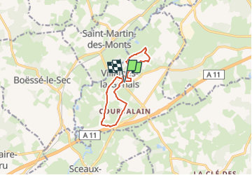
Tocht Stappen van 9,1 km beschikbaar op Pays de la Loire, Sarthe, Villaines-la-Gonais. Deze tocht wordt voorgesteld door darkpapa.

Beschrijving

départ salle polyvalente , quelques zones humide mais contournable , charmant village , élevage de cerfs cote autoroute , si on est matinal on peut croiser des animaux sauvage ;chevreuils sangliers
il existe un autre parcours référencé le brame des cerfs de 4km qui ne passe pas par les cerfs( Perche sarthois )

Hoogteprofiel

Plaatsbepaling

Land:
France
Regio :
Pays de la Loire
Departement/Provincie :
Sarthe
Gemeente :
Villaines-la-Gonais
Locatie:
Unknown
Vertrek:(UTM)
321706 ; 5334039 (31U) N.

Wandeltochten in de omgeving

Tocht Te voet Saint-Aubin-des-Coudrais - St Aubin PR-9 long - Photo
Te voet
darkpapa

Te voet

Medium
Saint-Aubin-des-Coudrais, Pays de la Loire, Sarthe, France
13,6 km | 16,4 km-effort
3h 42min
Ja
Tocht Stappen Saint-Maixent - Saint Maixent - L'eau vive - Photo
Stappen
tracegps

Stappen

Medium
Saint-Maixent, Pays de la Loire, Sarthe, France
8,7 km | 10,2 km-effort
2h 15min
Ja
Tocht Stappen Saint-Maixent - autour de la butte de montbauge - Photo
Stappen
darkpapa

Stappen

Moeilijk
Saint-Maixent, Pays de la Loire, Sarthe, France
11,8 km | 14 km-effort
3h 11min
Ja
Tocht Te voet Saint-Aubin-des-Coudrais - de bois gars a la lande - Photo
Te voet
darkpapa

Te voet

Gemakkelijk
Saint-Aubin-des-Coudrais, Pays de la Loire, Sarthe, France
12,3 km | 14,3 km-effort
3h 14min
Ja
Tocht Stappen Boëssé-le-Sec - Autour de Boesse - Photo
Stappen
darkpapa

Stappen

Gemakkelijk
Boëssé-le-Sec, Pays de la Loire, Sarthe, France
10,3 km | 12,7 km-effort
2h 53min
Ja
Tocht Stappen Saint-Aubin-des-Coudrais - rando 15 km 2024 - Photo
Stappen
darkpapa

Stappen

Moeilijk
Saint-Aubin-des-Coudrais, Pays de la Loire, Sarthe, France
14,5 km | 17,5 km-effort
3h 58min
Ja
Tocht Stappen Saint-Aubin-des-Coudrais - rando 9 km 2024 - Photo
Stappen
darkpapa

Stappen

Medium
Saint-Aubin-des-Coudrais, Pays de la Loire, Sarthe, France
8,2 km | 9,9 km-effort
2h 14min
Ja
Tocht Te voet Tuffé Val de la Chéronne - Saint-Hilaire le lierru - Photo
Te voet
darkpapa

Te voet

Gemakkelijk
Tuffé Val de la Chéronne, Pays de la Loire, Sarthe, France
10,3 km | 11,9 km-effort
2h 42min
Ja
Tocht Stappen Saint-Aubin-des-Coudrais -  la Mare de la lande - Photo
Stappen
darkpapa

Stappen

Gemakkelijk
Saint-Aubin-des-Coudrais, Pays de la Loire, Sarthe, France
8,6 km | 9,9 km-effort
2h 15min
Ja


Sluiten
Mijn abonnementen