![](/images/other/stat-length.png)
![Tocht Noords wandelen Ver-sur-Launette - Chapelle sainte Marguerite - Photo](https://media.geolcdn.com/t/1900/400/ext.pjpeg?maxdim=2&url=https%3A%2F%2Fstatic1.geolcdn.com%2Fsiteimages%2Fupload%2Ffiles%2F1545311037marcheuse_200dpi.jpg)
Chapelle sainte Marguerite
damerenvielle@gmail.com
Gebruiker
![Lengte](/images/other/stat-length.png)
![Max. hoogte](https://static1.geolcdn.com/siteimages/upload/files/1508320355ic_sort_altitude_max_24dp.png)
![Positief hoogteverschil](https://static1.geolcdn.com/siteimages/upload/files/1508320355ic_sort_den_pos_24dp.png)
![Km-Effort](/images/other/stat-length.png)
![Min. hoogte](https://static1.geolcdn.com/siteimages/upload/files/1508320355ic_sort_altitude_min_24dp.png)
![Negatief hoogteverschil](https://static1.geolcdn.com/siteimages/upload/files/1508320355ic_sort_den_neg_24dp.png)
![Boucle](https://static1.geolcdn.com/siteimages/upload/files/16400158638029165_repeat_loop_refresh_sync_direction_icon.png)
![Noords wandelen](https://static1.geolcdn.com/sitytour/trail-icons/102.png)
2h18
Moeilijkheid : Gemakkelijk
![Scan deze QR-code om de tocht te openen in de SityTrail-applicatie](https://capi.geolives.com/qq0zvz2zws4bq2lad0pu/sitytour/trails/4310439/qr.png?size=200)
Gratisgps-wandelapplicatie
Over ons
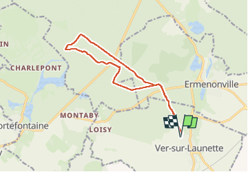
Tocht Noords wandelen van 13,4 km beschikbaar op Hauts-de-France, Oise, Ver-sur-Launette. Deze tocht wordt voorgesteld door damerenvielle@gmail.com.
Beschrijving
Au départ de Ver Sur Launette, en passant par l'aire de pique nique de Boisdhyver, le pavillon du prince, carrefour du carreau, carrefour du peuple, puis proche de la chapelle retour par le carrefour du bosquet rond et sur la route du même nom, la route anglaise et le pavillon du prince.
Plaatsbepaling
Opmerkingen
Wandeltochten in de omgeving
![Tocht Stappen Ermenonville - SM_ERMENONVILLE CHATEAU_NORD_8.1Km - Photo](https://media.geolcdn.com/t/375/260/7d446e19-5e6a-43bb-b3e7-8604a42003f5.jpg&format=jpg&maxdim=2)
![Stappen Stappen](https://static1.geolcdn.com/sitytour/trail-icons/101.png)
Stappen
![](/images/other/stat-length.png)
![](https://static1.geolcdn.com/siteimages/upload/files/16400158638029165_repeat_loop_refresh_sync_direction_icon.png)
![Tocht Stappen Fontaine-Chaalis - Abbaye de Chaalis+fiche+GPX_ 7,8Km_SM - Photo](https://media.geolcdn.com/t/375/260/657f82f2-464a-46f3-a6d5-6815f63cb655.jpg&format=jpg&maxdim=2)
![Stappen Stappen](https://static1.geolcdn.com/sitytour/trail-icons/101.png)
Stappen
![](/images/other/stat-length.png)
![](https://static1.geolcdn.com/siteimages/upload/files/16400158638029165_repeat_loop_refresh_sync_direction_icon.png)
![Tocht Stappen Ver-sur-Launette - SM_VER-sur-LAUNETTE_8.5Km - Photo](https://media.geolcdn.com/t/375/260/e4a0fe41-690f-4014-9611-5ec255c04f3d.jpg&format=jpg&maxdim=2)
![Stappen Stappen](https://static1.geolcdn.com/sitytour/trail-icons/101.png)
Stappen
![](/images/other/stat-length.png)
![](https://static1.geolcdn.com/siteimages/upload/files/16400158638029165_repeat_loop_refresh_sync_direction_icon.png)
![Tocht Stappen Fontaine-Chaalis - Abbaye de Chaalis Supermini Rando - Photo](https://media.geolcdn.com/t/375/260/15af4e3c-b372-40df-abf5-027cf19e5dd0.jpg&format=jpg&maxdim=2)
![Stappen Stappen](https://static1.geolcdn.com/sitytour/trail-icons/101.png)
Stappen
![](/images/other/stat-length.png)
![](https://static1.geolcdn.com/siteimages/upload/files/16400158638029165_repeat_loop_refresh_sync_direction_icon.png)
![Tocht Stappen Ermenonville - Ermenonville Chateau 6,3 Km - Photo](https://media.geolcdn.com/t/375/260/4ced2ae2-3324-4103-b3b1-afffd891ea1f.jpg&format=jpg&maxdim=2)
![Stappen Stappen](https://static1.geolcdn.com/sitytour/trail-icons/101.png)
Stappen
![](/images/other/stat-length.png)
![](https://static1.geolcdn.com/siteimages/upload/files/16400158638029165_repeat_loop_refresh_sync_direction_icon.png)
![Tocht Stappen Montagny-Sainte-Félicité - SM_MONTAGNY_Ste-FELECITE_8.5Km - Photo](https://media.geolcdn.com/t/375/260/7f77d429-995c-4fbd-8931-c05c864ab4aa.jpg&format=jpg&maxdim=2)
![Stappen Stappen](https://static1.geolcdn.com/sitytour/trail-icons/101.png)
Stappen
![](/images/other/stat-length.png)
![](https://static1.geolcdn.com/siteimages/upload/files/16400158638029165_repeat_loop_refresh_sync_direction_icon.png)
![Tocht Stappen Ver-sur-Launette - SM_LOISY_8.5Km - Photo](https://media.geolcdn.com/t/375/260/11537f1c-9100-4fb5-a43a-20a54cad8fb4.jpg&format=jpg&maxdim=2)
![Stappen Stappen](https://static1.geolcdn.com/sitytour/trail-icons/101.png)
Stappen
![](/images/other/stat-length.png)
![](https://static1.geolcdn.com/siteimages/upload/files/16400158638029165_repeat_loop_refresh_sync_direction_icon.png)
![Tocht Stappen Othis - SM_BEAUMARCHAIS_8.2Km - Photo](https://media.geolcdn.com/t/375/260/77e12fa5-e8b4-47fd-984a-c11823705817.jpg&format=jpg&maxdim=2)
![Stappen Stappen](https://static1.geolcdn.com/sitytour/trail-icons/101.png)
Stappen
![](/images/other/stat-length.png)
![](https://static1.geolcdn.com/siteimages/upload/files/16400158638029165_repeat_loop_refresh_sync_direction_icon.png)
![Tocht Stappen Fontaine-Chaalis - MR_ERMENONVILLE-Maison-Blanche_EST_5.8Km - Photo](https://media.geolcdn.com/t/375/260/9923fd81-5d90-403c-9e41-4a668aba5ad7.jpg&format=jpg&maxdim=2)
![Stappen Stappen](https://static1.geolcdn.com/sitytour/trail-icons/101.png)
Stappen
![](/images/other/stat-length.png)
![](https://static1.geolcdn.com/siteimages/upload/files/16400158638029165_repeat_loop_refresh_sync_direction_icon.png)