![](/images/other/stat-length.png)
![Tocht Stappen Orsières - Cabane de l''A Neuve - Photo](https://media.geolcdn.com/t/1900/400/ext.pjpeg?maxdim=2&url=https%3A%2F%2Fservices.sitytrail.com%2FGeolivesWS%2FDownloadMedia.ashx%3FTrailID%3D43029%26Media%3Dimage0.jpg)
Cabane de l''A Neuve
verbier
Gebruiker
![Lengte](/images/other/stat-length.png)
Lengte
5,4 km
![Max. hoogte](https://static1.geolcdn.com/siteimages/upload/files/1508320355ic_sort_altitude_max_24dp.png)
Max. hoogte
2718 m
![Positief hoogteverschil](https://static1.geolcdn.com/siteimages/upload/files/1508320355ic_sort_den_pos_24dp.png)
Positief hoogteverschil
1115 m
![Km-Effort](/images/other/stat-length.png)
Km-Effort
16,6 km
![Min. hoogte](https://static1.geolcdn.com/siteimages/upload/files/1508320355ic_sort_altitude_min_24dp.png)
Min. hoogte
1591 m
![Negatief hoogteverschil](https://static1.geolcdn.com/siteimages/upload/files/1508320355ic_sort_den_neg_24dp.png)
Negatief hoogteverschil
18 m
![Boucle](https://static1.geolcdn.com/siteimages/upload/files/16400158638029165_repeat_loop_refresh_sync_direction_icon.png)
Boucle
Neen
Datum van aanmaak :
2014-12-10 00:00:00.0
Laatste wijziging :
2014-12-10 00:00:00.0
![Stappen](https://static1.geolcdn.com/sitytour/trail-icons/101.png)
2h43
Moeilijkheid : Onbekend
![Scan deze QR-code om de tocht te openen in de SityTrail-applicatie](https://capi.geolives.com/qq0zvz2zws4bq2lad0pu/sitytour/trails/43029/qr.png?size=200)
Gratisgps-wandelapplicatie
Over ons
Tocht Stappen van 5,4 km beschikbaar op Valais/Wallis, Entremont, Orsières. Deze tocht wordt voorgesteld door verbier.
Beschrijving
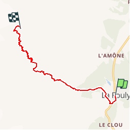
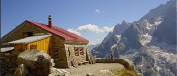
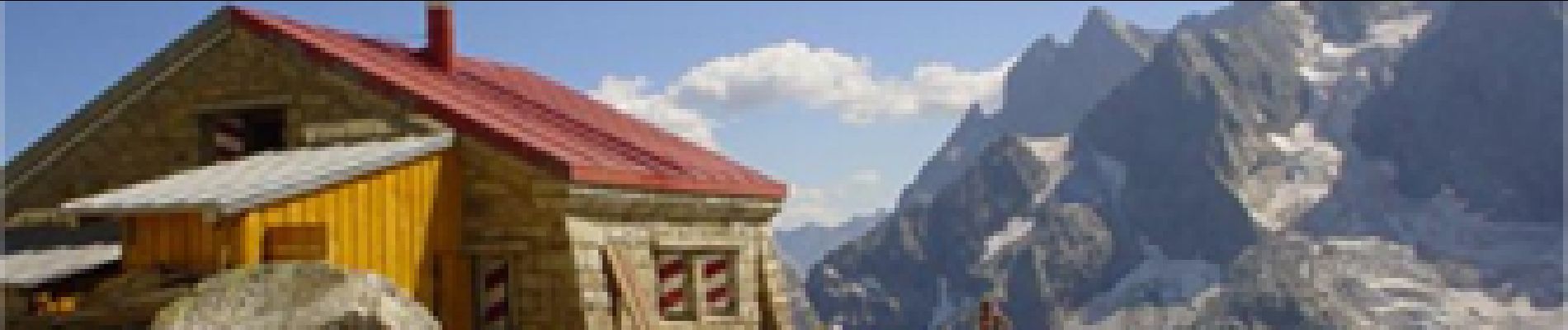
Départ de La Fouly vers le camping, sentier qui monte le long de la reuse de l''Amône jusqu''au lieu dit Pierre Javelle. Continuer le sentier sinueux, avec passage de chaînes, jusqu''à la cabane de l''A Neuve, située à côté du glacier du même nom.
Plaatsbepaling
Land:
Switzerland
Regio :
Valais/Wallis
Departement/Provincie :
Entremont
Gemeente :
Orsières
Locatie:
Unknown
Vertrek:(Dec)
Vertrek:(UTM)
352603 ; 5088379 (32T) N.
Opmerkingen
Wandeltochten in de omgeving
![Tocht Te voet Orsières - Trail Verbier St-Bernard - Traversée - Photo](https://media.geolcdn.com/t/375/260/dafbc912-1c22-4e42-aaf9-5568981fc800.jpeg&format=jpg&maxdim=2)
![Te voet Te voet](https://static1.geolcdn.com/sitytour/trail-icons/100.png)
Trail Verbier St-Bernard - Traversée
Te voet
Zeer moeilijk
Orsières,
Valais/Wallis,
Entremont,
Switzerland
![](/images/other/stat-length.png)
37 km | 70 km-effort
15h 47min
![](https://static1.geolcdn.com/siteimages/upload/files/16400158638029165_repeat_loop_refresh_sync_direction_icon.png)
Neen
![Tocht Te voet Orsières - Sentier des Bergers - Photo](https://media.geolcdn.com/t/375/260/a8cdee56-d9cf-46a0-9048-05577c82dfc2.jpeg&format=jpg&maxdim=2)
![Te voet Te voet](https://static1.geolcdn.com/sitytour/trail-icons/100.png)
Sentier des Bergers
Te voet
Gemakkelijk
Orsières,
Valais/Wallis,
Entremont,
Switzerland
![](/images/other/stat-length.png)
4,8 km | 9,2 km-effort
2h 5min
![](https://static1.geolcdn.com/siteimages/upload/files/16400158638029165_repeat_loop_refresh_sync_direction_icon.png)
Neen
![Tocht Stappen Orsières - La Fouly Ferret - Photo](https://media.geolcdn.com/t/375/260/9ccbcdc3-96f7-4967-963b-9422de80e17a.jpg&format=jpg&maxdim=2)
![Stappen Stappen](https://static1.geolcdn.com/sitytour/trail-icons/101.png)
La Fouly Ferret
Stappen
Medium
Orsières,
Valais/Wallis,
Entremont,
Switzerland
![](/images/other/stat-length.png)
6,4 km | 9,7 km-effort
2h 58min
![](https://static1.geolcdn.com/siteimages/upload/files/16400158638029165_repeat_loop_refresh_sync_direction_icon.png)
Ja
![Tocht Te voet Courmayeur - Itinerario 23 Rifugio Dalmazzi - Photo](https://media.geolcdn.com/t/375/260/2530e1b3-3a61-40c9-a091-23aae0135330.jpeg&format=jpg&maxdim=2)
![Te voet Te voet](https://static1.geolcdn.com/sitytour/trail-icons/100.png)
Itinerario 23 Rifugio Dalmazzi
Te voet
Gemakkelijk
Courmayeur,
Valle d'Aosta,
Onbekend,
Italy
![](/images/other/stat-length.png)
4,1 km | 6,6 km-effort
1h 29min
![](https://static1.geolcdn.com/siteimages/upload/files/16400158638029165_repeat_loop_refresh_sync_direction_icon.png)
Neen
![Tocht Stappen Orsières - La Fouly, Randonée hivernale, Sentier de l''Amône - Photo](https://media.geolcdn.com/t/375/260/ext.jpg?maxdim=2&url=https%3A%2F%2Fstatic1.geolcdn.com%2Fsiteimages%2Fupload%2Ffiles%2F1553511878bg_sport_marche.png)
![Stappen Stappen](https://static1.geolcdn.com/sitytour/trail-icons/101.png)
La Fouly, Randonée hivernale, Sentier de l''Amône
Stappen
Heel gemakkelijk
(1)
Orsières,
Valais/Wallis,
Entremont,
Switzerland
![](/images/other/stat-length.png)
1,9 km | 2,7 km-effort
50min
![](https://static1.geolcdn.com/siteimages/upload/files/16400158638029165_repeat_loop_refresh_sync_direction_icon.png)
Ja
![Tocht Stappen Orsières - ferret La Foully - Photo](https://media.geolcdn.com/t/375/260/63d1d980-6a97-41e6-89ba-75cc5f32987c.jpg&format=jpg&maxdim=2)
![Stappen Stappen](https://static1.geolcdn.com/sitytour/trail-icons/101.png)
ferret La Foully
Stappen
Medium
Orsières,
Valais/Wallis,
Entremont,
Switzerland
![](/images/other/stat-length.png)
4,6 km | 6,1 km-effort
2h 20min
![](https://static1.geolcdn.com/siteimages/upload/files/16400158638029165_repeat_loop_refresh_sync_direction_icon.png)
Neen
![Tocht Stappen Orsières - fully - Photo](https://media.geolcdn.com/t/375/260/2c6e4eef-8fbd-4687-9f38-cba51571dc4d.jpg&format=jpg&maxdim=2)
![Stappen Stappen](https://static1.geolcdn.com/sitytour/trail-icons/101.png)
fully
Stappen
Gemakkelijk
Orsières,
Valais/Wallis,
Entremont,
Switzerland
![](/images/other/stat-length.png)
3,8 km | 4,9 km-effort
1h 19min
![](https://static1.geolcdn.com/siteimages/upload/files/16400158638029165_repeat_loop_refresh_sync_direction_icon.png)
Neen
![Tocht Stappen Orsières - TMB J3 La FOULY - Ref. ELENA - Photo](https://media.geolcdn.com/t/375/260/ext.jpg?maxdim=2&url=https%3A%2F%2Fservices.sitytrail.com%2FGeolivesWS%2FDownloadMedia.ashx%3FTrailID%3D594964%26Media%3Dfix__20160705112101.jpg)
![Stappen Stappen](https://static1.geolcdn.com/sitytour/trail-icons/101.png)
TMB J3 La FOULY - Ref. ELENA
Stappen
Moeilijk
Orsières,
Valais/Wallis,
Entremont,
Switzerland
![](/images/other/stat-length.png)
10,3 km | 23 km-effort
4h 46min
![](https://static1.geolcdn.com/siteimages/upload/files/16400158638029165_repeat_loop_refresh_sync_direction_icon.png)
Neen
![Tocht Stappen Orsières - w_CHpur05_lafouly - Photo](https://media.geolcdn.com/t/375/260/ext.jpg?maxdim=2&url=https%3A%2F%2Fstatic1.geolcdn.com%2Fsiteimages%2Fupload%2Ffiles%2F1553511878bg_sport_marche.png)
![Stappen Stappen](https://static1.geolcdn.com/sitytour/trail-icons/101.png)
w_CHpur05_lafouly
Stappen
Heel gemakkelijk
Orsières,
Valais/Wallis,
Entremont,
Switzerland
![](/images/other/stat-length.png)
15,4 km | 30 km-effort
Onbekend
![](https://static1.geolcdn.com/siteimages/upload/files/16400158638029165_repeat_loop_refresh_sync_direction_icon.png)
Ja